gis Courses
Comprehensive gis training programs for professionals
Comprehensive gis training programs for professionals
Training Course on Data Wrangling and Feature Engineering for Spatial Models provides a comprehensive deep dive into Data Wrangling and Feature Engineering techniques specifically tailored for spatial models.
Training Course on Data Wrangling and Feature Engineering for Spatial Models provides a comprehensive deep dive into Data Wrangling and Feature Engineering techniques specifically tailored for spatial models.
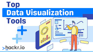
Training Course on Data Visualization Libraries for Web GIS (D3.js, Deck.gl) addresses the growing demand for skilled professionals who can bridge the gap between complex geographical information systems and intuitive web-based experiences.
Training Course on Data Visualization Libraries for Web GIS (D3.js, Deck.gl) addresses the growing demand for skilled professionals who can bridge the gap between complex geographical information systems and intuitive web-based experiences.
Training Course on Cloud-Native GIS Applications on Azure explores the exciting convergence of Geographic Information Systems (GIS) and Cloud-Native architectures on the Microsoft Azure platform.
Training Course on Cloud-Native GIS Applications on Azure explores the exciting convergence of Geographic Information Systems (GIS) and Cloud-Native architectures on the Microsoft Azure platform.
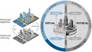
Training Course on Digital Twin for Urban Operations and Planning is designed to equip professionals with the essential knowledge and practical skills to leverage this transformative technology.
Training Course on Digital Twin for Urban Operations and Planning is designed to equip professionals with the essential knowledge and practical skills to leverage this transformative technology.
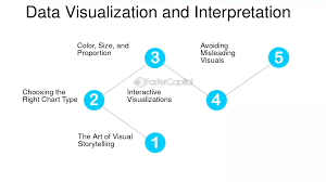
Training Course on Data Visualization for Complex Geospatial Datasets focuses on developing practical skills in geospatial analytics and cartographic design principles to tackle real-world challenges.
Training Course on Data Visualization for Complex Geospatial Datasets focuses on developing practical skills in geospatial analytics and cartographic design principles to tackle real-world challenges.
Training Course on Cartographic Design and Advanced Map Production for Decision Making equips professionals with cutting-edge techniques and geospatial technologies to create compelling visual narratives
Training Course on Cartographic Design and Advanced Map Production for Decision Making equips professionals with cutting-edge techniques and geospatial technologies to create compelling visual narratives
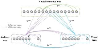
Training Course on Causal Inference in Spatial Data delves into cutting-edge methodologies that integrate spatial econometrics, machine learning for causal inference, and geographical information systems (GIS) to rigorously analyze spatial data
Training Course on Causal Inference in Spatial Data delves into cutting-edge methodologies that integrate spatial econometrics, machine learning for causal inference, and geographical information systems (GIS) to rigorously analyze spatial data
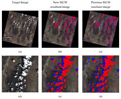
Training Course on Cloud Masking and Quality Control in Remote Sensing is designed to equip participants with the essential knowledge and practical skills in cloud masking and quality control, transforming raw, cloud-contaminated data into analysis-ready information.
Training Course on Cloud Masking and Quality Control in Remote Sensing is designed to equip participants with the essential knowledge and practical skills in cloud masking and quality control, transforming raw, cloud-contaminated data into analysis-ready information.
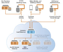
Training Course on Cloud-Native GIS Applications on AWS provides a comprehensive exploration of Cloud-Native GIS Applications on AWS, empowering geospatial professionals and developers to leverage the full potential of Amazon Web Services for scalable, resilient, and performant GIS solutions.
Training Course on Cloud-Native GIS Applications on AWS provides a comprehensive exploration of Cloud-Native GIS Applications on AWS, empowering geospatial professionals and developers to leverage the full potential of Amazon Web Services for scalable, resilient, and performant GIS solutions.
Training Course on Advanced Spatial Data Models and Database Design provides a comprehensive deep dive into the critical concepts and practical applications of Advanced Spatial Data Models and Geospatial Database Design
Training Course on Advanced Spatial Data Models and Database Design provides a comprehensive deep dive into the critical concepts and practical applications of Advanced Spatial Data Models and Geospatial Database Design
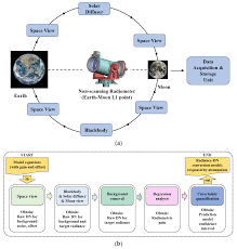
Training Course on Atmospheric Correction and Radiometric Calibration of Imagery addresses this critical need by equipping professionals with the expertise to process and analyze large-scale imagery datasets efficiently, leveraging the power of Apache Spark and Hadoop for distributed computing.
Training Course on Atmospheric Correction and Radiometric Calibration of Imagery addresses this critical need by equipping professionals with the expertise to process and analyze large-scale imagery datasets efficiently, leveraging the power of Apache Spark and Hadoop for distributed computing.
Training Course on Big Geospatial Data + AI for Advanced Analytics delves into the transformative convergence of Big Geospatial Data and Artificial Intelligence (AI), empowering professionals with cutting-edge skills for advanced analytics.
Training Course on Big Geospatial Data + AI for Advanced Analytics delves into the transformative convergence of Big Geospatial Data and Artificial Intelligence (AI), empowering professionals with cutting-edge skills for advanced analytics.