gis Courses
Comprehensive gis training programs for professionals
Comprehensive gis training programs for professionals
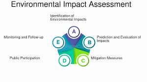
GIS for Environmental Impact Assessment (EIA) Training Course provides professionals with the cutting-edge geospatial tools and methodologies necessary to conduct thorough, data-driven EIAs.
GIS for Environmental Impact Assessment (EIA) Training Course provides professionals with the cutting-edge geospatial tools and methodologies necessary to conduct thorough, data-driven EIAs.
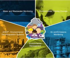
GIS for Environmental Pollution Monitoring Training Course provides environmental professionals with the cutting-edge skills to leverage Geographic Information Systems (GIS) for effective environmental pollution monitoring and management
GIS for Environmental Pollution Monitoring Training Course provides environmental professionals with the cutting-edge skills to leverage Geographic Information Systems (GIS) for effective environmental pollution monitoring and management
Geographic Information Systems for Epidemiology and Disease Surveillance Training Course introduces the powerful synergy between Geographic Information Systems (GIS) and the critical fields of epidemiology and disease surveillance.
Geographic Information Systems for Epidemiology and Disease Surveillance Training Course introduces the powerful synergy between Geographic Information Systems (GIS) and the critical fields of epidemiology and disease surveillance.
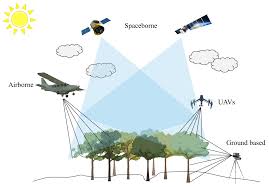
Remote Sensing for Forestry and Vegetation Management Training Course emphasizes hands-on experience with open-source tools and real-world case studies, fostering a deep understanding of data acquisition, processing, and interpretation in forestry and ecological contexts
Remote Sensing for Forestry and Vegetation Management Training Course emphasizes hands-on experience with open-source tools and real-world case studies, fostering a deep understanding of data acquisition, processing, and interpretation in forestry and ecological contexts
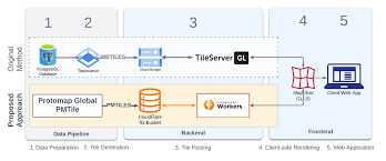
Scalable Web Mapping with Vector Tiles Training Course delves into the cutting-edge realm of scalable web mapping using vector tiles.
Scalable Web Mapping with Vector Tiles Training Course delves into the cutting-edge realm of scalable web mapping using vector tiles.
Serverless GIS Architectures Training Course liberates organizations from the complexities of managing underlying infrastructure, enabling them to focus entirely on geospatial data analysis, application development, and delivering innovative location-based services.
Serverless GIS Architectures Training Course liberates organizations from the complexities of managing underlying infrastructure, enabling them to focus entirely on geospatial data analysis, application development, and delivering innovative location-based services.
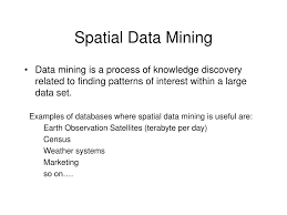
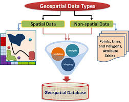
Spatial Data Mining and Pattern Discovery Training Course is designed to equip professionals with the critical skills needed to navigate the challenges and opportunities presented by Big Spatial Data.
Spatial Data Mining and Pattern Discovery Training Course is designed to equip professionals with the critical skills needed to navigate the challenges and opportunities presented by Big Spatial Data.
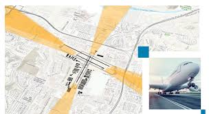
GIS for Aviation and Airport Management Training Course emphasizes hands-on experience with cutting-edge GIS software, empowering participants to leverage geospatial intelligence for improved situational awareness, proactive risk management, and data-driven operational efficiency.
GIS for Aviation and Airport Management Training Course emphasizes hands-on experience with cutting-edge GIS software, empowering participants to leverage geospatial intelligence for improved situational awareness, proactive risk management, and data-driven operational efficiency.
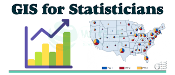
GIS for Census and Demographics Analysis Training Course is meticulously designed to empower professionals with the cutting-edge geospatial technologies and analytical methodologies required to effectively capture, manage, analyze, and visualize population data
GIS for Census and Demographics Analysis Training Course is meticulously designed to empower professionals with the cutting-edge geospatial technologies and analytical methodologies required to effectively capture, manage, analyze, and visualize population data
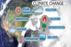
GIS for Climate Change Adaptation and Mitigation Training Course is meticulously designed to equip participants with the essential geospatial skills and cutting-edge knowledge required to effectively address the complex challenges posed by a changing climate, fostering resilient communities and sustainable development.
GIS for Climate Change Adaptation and Mitigation Training Course is meticulously designed to equip participants with the essential geospatial skills and cutting-edge knowledge required to effectively address the complex challenges posed by a changing climate, fostering resilient communities and sustainable development.
Geospatial A/B Testing and Spatial Experiment Design Training Course delves into the theoretical foundations and practical applications of spatial statistics, experimental design, and geospatial analytics
Geospatial A/B Testing and Spatial Experiment Design Training Course delves into the theoretical foundations and practical applications of spatial statistics, experimental design, and geospatial analytics
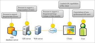
Geospatial Security for Web GIS Application Training Course addresses the urgent need for skilled professionals capable of securing these vital systems.
Geospatial Security for Web GIS Application Training Course addresses the urgent need for skilled professionals capable of securing these vital systems.