Web Mercator and Tiled Web Maps Optimization Training Course
Web Mercator and Tiled Web Maps Optimization Training Course goes beyond theoretical concepts, focusing on practical implementation and performance tuning for real-world scenarios.
Course Overview
Web Mercator and Tiled Web Maps Optimization Training Course
Introduction
In today's digitally driven world, interactive web maps are indispensable for conveying spatial information across diverse sectors, from logistics and urban planning to environmental monitoring and public services. The pervasive adoption of online mapping platforms like Google Maps, OpenStreetMap, and ArcGIS Online has fundamentally reshaped how we visualize and interact with geographic data. At the heart of this revolution lie two foundational technologies: The Web Mercator projection and tiled web maps. While these technologies offer unparalleled accessibility and performance, their optimal utilization hinges on a deep understanding of their underlying principles and effective optimization strategies. This training course delves into the intricacies of Web Mercator and tiled web maps, equipping participants with the essential skills and cutting-edge techniques to enhance map rendering performance, ensure data efficiency, and deliver superior user experiences in their web mapping applications.
Web Mercator and Tiled Web Maps Optimization Training Course goes beyond theoretical concepts, focusing on practical implementation and performance tuning for real-world scenarios. Participants will gain hands-on experience with industry-standard tools and frameworks, learning to identify and mitigate common performance bottlenecks associated with large geospatial datasets and high-traffic web mapping services. By mastering the art of tile caching, vector tile generation, and client-side rendering optimization, attendees will be empowered to build highly responsive, scalable, and visually compelling web maps that meet the demands of modern digital environments. The course emphasizes best practices in web GIS development, ensuring that participants can contribute to creating efficient and impactful spatial solutions.
Course Duration
10 days
Course Objectives
Upon completion of this training course, participants will be able to:
- Comprehend the fundamental principles, advantages, and limitations of the Web Mercator projection (EPSG:3857) in modern web mapping platforms.
- Develop advanced strategies for generating, serving, and caching tiled web maps to maximize performance and minimize server load.
- Implement techniques for smooth map navigation, fast loading times, and responsive interactions in web-based GIS applications.
- Efficiently handle and visualize big geospatial data through effective tiling and data reduction methodologies.
- Apply client-side and server-side rendering optimization techniques for both raster and vector tiles.
- Design and deploy robust tile caching strategies using tools like GeoWebCache and other tile servers.
- Utilize OGC web services (WMS, WMTS) and open-source mapping libraries (OpenLayers, Leaflet) for optimal integration.
- Explore the benefits and implementation of vector tiles for dynamic styling and reduced bandwidth usage.
- Create mobile-friendly web maps that adapt seamlessly across various devices and screen sizes.
- Utilize tools and methodologies for web map performance monitoring and bottleneck identification.
- Implement security best practices for protecting geospatial data and web mapping infrastructure.
- Understand emerging trends in 3D web mapping, real-time GIS, and AI-powered mapping.
- Diagnose and resolve common performance issues in web GIS applications.
Organizational Benefits
- Faster loading times and smoother user interactions lead to increased user engagement and satisfaction.
- Optimized tile generation and caching significantly lower server load and bandwidth consumption.
- Ability to efficiently manage and serve large and growing geospatial datasets.
- Highly performant and interactive maps facilitate quicker and more informed spatial analysis.
- Development of cutting-edge web mapping applications that stand out in the market.
- Empowering teams with expertise in the latest web mapping optimization techniques.
- Streamlined data delivery and visualization processes across departments.
Target Audience
- GIS Developers & Engineers.
- Web Developers.
- Cartographers & Map Designers.
- Geospatial Analysts.
- System Architects.
- Data Scientists.
- Project Managers.
- Anyone working with web-based GIS requiring an in-depth understanding of performance and best practices.
Course Outline
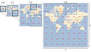
Module 1: Introduction to Web Mercator and Tiled Web Maps
- Understanding the evolution of web mapping and its impact.
- Fundamentals of map projections: Focus on Web Mercator (EPSG:3857) and its global adoption.
- Introduction to tiled web maps: How they work, advantages, and challenges.
- Comparison of raster tiles vs. vector tiles.
- Overview of key web mapping standards and protocols
- Case Study: Analyzing Google Maps' early adoption of Web Mercator and tiled architecture for global scalability.
Module 2: Web Mercator: Properties, Pros, and Cons
- Detailed examination of Web Mercator's mathematical properties and distortions.
- Why Web Mercator became the de facto standard for web mapping.
- Addressing common criticisms and limitations of the projection.
- Impact of Web Mercator on spatial analysis and data accuracy.
- Strategies for handling projection discrepancies with other GIS datasets.
- Case Study: Discussing the challenges faced by cartographers in representing polar regions accurately with Web Mercator and alternative projection approaches.
Module 3: Tile Generation and Management
- Strategies for generating optimal map tiles
- Understanding zoom levels, tile matrix sets, and tile addressing schemes
- Tools and software for tile generation
- Managing tile pyramids for different scales and resolutions.
- Automating tile generation workflows for large datasets.
- Case Study: A municipality optimizing its public-facing parcel map by pre-generating tiles for common zoom levels, drastically reducing server-side rendering.
Module 4: Server-Side Optimization for Tiled Maps
- Configuring and optimizing popular tile servers
- Leveraging server-side caching mechanisms
- Implementing efficient data storage strategies for tiles.
- Load balancing and scaling tile serving infrastructure.
- Monitoring server performance and identifying bottlenecks.
- Case Study: A large national mapping agency significantly improving the delivery speed of its topographic basemaps by implementing a distributed GeoWebCache architecture.
Module 5: Client-Side Rendering and Performance
- Understanding how web browsers render map tiles and vector data.
- Optimizing JavaScript libraries for performance.
- Techniques for reducing client-side processing and memory usage.
- Lazy loading, tile prefetching, and progressive rendering strategies.
- Hardware acceleration and GPU utilization in web map rendering.
- Case Study: A real estate platform reducing initial map load times by implementing lazy loading of map tiles and feature data based on user viewport.
Module 6: Vector Tiles: Generation and Styling
- Introduction to vector tiles: Structure, advantages over raster tiles.
- Tools and workflows for generating vector tiles
- Dynamic styling of vector tiles using Mapbox Style Specification or custom CSS.
- Client-side rendering of vector data for enhanced interactivity.
- Handling large vector datasets efficiently with simplification and generalization.
- Case Study: A transportation company switching from raster to vector tiles for their real-time vehicle tracking map, enabling custom styling and reduced bandwidth usage for mobile clients.
Module 7: Data Optimization for Web Maps
- Techniques for simplifying geographic features to reduce data size.
- Strategies for generalizing detailed datasets for lower zoom levels.
- Attribute data optimization and efficient data serialization formats
- Using spatial indexes for faster data retrieval.
- Implementing data streaming and pagination for large query results.
- Case Study: An environmental monitoring agency optimizing sensor data visualization by simplifying complex geometries and implementing dynamic data aggregation for different zoom levels.
Module 8: Web Map Performance Testing and Monitoring
- Identifying key performance metrics for web maps
- Tools for performance profiling and debugging web mapping applications
- Benchmarking different optimization strategies.
- Continuous performance monitoring in production environments.
- Reporting and analyzing performance data.
- Case Study: An e-commerce delivery service using performance monitoring tools to identify and resolve latency issues in their driver tracking map, leading to improved delivery efficiency.
Module 9: Advanced Tile Caching Strategies
- Cache invalidation and update mechanisms for dynamic data.
- Implementing tile seeding and pre-caching for critical areas.
- Using content delivery networks (CDNs) for distributed tile delivery.
- Offline mapping capabilities with local tile storage.
- Strategies for handling expiring data and real-time updates.
- Case Study: A public utility company implementing a robust CDN strategy for its service outage map, ensuring high availability and rapid response during peak demand.
Module 10: Mobile Web Map Optimization
- Designing responsive web maps for various mobile devices.
- Optimizing image assets and reducing network requests for mobile.
- Gestural interactions and touch-friendly UI design for maps.
- Location services integration and GPS accuracy considerations.
- Performance considerations for limited bandwidth and processing power.
- Case Study: A tourism application optimizing its interactive city guide map for mobile users by reducing tile sizes and leveraging device-specific rendering capabilities, improving user satisfaction on the go.
Module 11: Security in Web Mercator and Tiled Web Maps
- Protecting sensitive geospatial data on web servers.
- Authentication and authorization for map services.
- Preventing common web security vulnerabilities
- Securing API keys and access tokens for third-party mapping services.
- Compliance with data privacy regulations (GDPR, CCPA) for location data.
- Case Study: A governmental agency implementing strict access controls and API key management for its internal and public-facing web maps containing sensitive demographic data.
Module 12: Integrating with Geospatial Databases
- Connecting web mapping applications to spatial databases
- Optimizing spatial queries for fast data retrieval.
- Using database functions for on-the-fly data processing and aggregation.
- Database indexing strategies for geospatial data.
- Replication and synchronization of spatial data for distributed systems.
- Case Study: A logistics company optimizing its route planning web application by connecting directly to a PostGIS database for real-time traffic data and dynamic route calculations.
Module 13: Web Mercator and Tiling in Cloud Environments
- Leveraging cloud platforms (AWS, Azure, Google Cloud) for scalable web mapping.
- Utilizing cloud-based storage for map tiles
- Serverless functions for on-demand tile rendering or data processing.
- Managed GIS services in the cloud
- Cost optimization strategies for cloud-hosted web maps.
- Case Study: A startup building a global environmental monitoring platform using AWS Lambda for on-demand processing of satellite imagery into Web Mercator tiles, achieving massive scalability at a reduced cost.
Module 14: Emerging Trends in Web Mapping Optimization
- Introduction to 3D web mapping and its performance implications.
- Real-time geospatial data visualization and streaming.
- AI and Machine Learning in map optimization
- WebAssembly and WebGPU for high-performance client-side rendering.
- Server-side rendering of vector data for extreme performance.
- Case Study: Exploring how a smart city initiative is using real-time sensor data streamed to a web map, with AI optimizing data delivery and visualization for immediate insights into urban conditions.
Module 15: Best Practices and Future-Proofing
- Developing a comprehensive web map optimization strategy.
- Establishing performance baselines and continuous improvement cycles.
- Staying updated with new technologies and industry standards.
- Building a scalable and maintainable web GIS architecture.
- Case studies of successful large-scale web map deployments and their optimization journeys.
- Case Study: A national land registry migrating its entire geospatial data portal to a modern web mapping architecture, implementing a phased optimization strategy that resulted in a 50% performance improvement and reduced maintenance overhead.
Training Methodology
- Instructor-Led Presentations: Clear and concise explanations of theoretical concepts.
- Hands-on Labs & Exercises: Practical application of concepts using industry-standard tools and frameworks.
- Live Coding Demonstrations: Step-by-step guidance on implementing optimization techniques.
- Case Study Analysis: In-depth discussion of real-world scenarios and problem-solving approaches.
- Group Discussions & Q&A: Fostering collaborative learning and addressing specific participant challenges.
- Code Review & Feedback: Opportunity for participants to receive constructive criticism on their practical implementations.
- Problem-Based Learning: Participants will work on challenges that simulate real-world web map optimization issues.
Register as a group from 3 participants for a Discount
Send us an email: info@datastatresearch.org or call +254724527104
Certification
Upon successful completion of this training, participants will be issued with a globally- recognized certificate.
Tailor-Made Course
We also offer tailor-made courses based on your needs.
Key Notes
a. The participant must be conversant with English.
b. Upon completion of training the participant will be issued with an Authorized Training Certificate
c. Course duration is flexible and the contents can be modified to fit any number of days.
d. The course fee includes facilitation training materials, 2 coffee breaks, buffet lunch and A Certificate upon successful completion of Training.
e. One-year post-training support Consultation and Coaching provided after the course.
f. Payment should be done at least a week before commence of the training, to DATASTAT CONSULTANCY LTD account, as indicated in the invoice so as to enable us prepare better for you.