Vector Data Editing and Quality Control Best Practices Training Course
Vector Data Editing and Quality Control Best Practices Training Course provides GIS professionals and data stewards with the essential knowledge and practical skills required for meticulous vector data editing and the implementation of robust quality control protocols.
Course Overview
Vector Data Editing and Quality Control Best Practices Training Course
Introduction
Vector Data Editing and Quality Control Best Practices Training Course provides GIS professionals and data stewards with the essential knowledge and practical skills required for meticulous vector data editing and the implementation of robust quality control protocols. In today's data-driven world, the accuracy and reliability of geospatial data are paramount for informed decision-making across various sectors, from urban planning and environmental management to disaster response and asset management. Participants will learn to identify, correct, and prevent common data errors, ensuring the integrity and fitness-for-purpose of their vector datasets.
The course emphasizes industry best practices and leverages both open-source and commercial GIS software tools to equip participants with a comprehensive toolkit for geospatial data quality assurance. Through hands-on exercises, real-world case studies, and interactive discussions, attendees will gain confidence in performing advanced editing techniques, applying topological rules, managing metadata effectively, and implementing automated validation workflows. This foundational expertise is critical for any organization seeking to optimize its GIS operations, enhance data trustworthiness, and achieve superior spatial analysis outcomes.
Course Duration
5 days
Course Objectives
- Master Geospatial Data Accuracy and Precision Principles.
- Implement Vector Data Topology Rules and Validation.
- Utilize Advanced GIS Editing Techniques for Feature Correction.
- Develop Comprehensive Data Quality Assurance (DQA) Frameworks.
- Perform Automated Data Validation and Error Detection.
- Understand and Apply Metadata Standards for Geospatial Assets.
- Optimize Spatial Data Integrity and Consistency.
- Conduct Effective Data Cleaning and Pre-processing Workflows.
- Leverage Geodatabase Management Best Practices.
- Explore Open-Source GIS Tools for Quality Control.
- Implement Version Control for Collaborative Data Environments.
- Analyze Geospatial Data Governance and Stewardship.
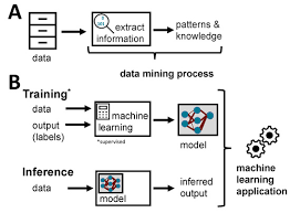
- Apply Machine Learning for Data Quality Enhancement (Introduction).
Organizational Benefits
- Rely on highly accurate and trusted geospatial data for strategic planning and operational decisions.
- Minimize errors, rework, and time spent on data correction through proactive quality control.
- Foster confidence in data products across departments and with external stakeholders.
- Streamline data editing and validation workflows, leading to faster project completion.
- Optimize resource deployment based on reliable spatial insights.
- Ensure adherence to data standards and reduce risks associated with erroneous data.
- Facilitate seamless data sharing and integration within and between organizations.
- Protect and extend the lifespan of valuable geospatial datasets.
Target Audience
- GIS Analysts and Specialists.
- Cartographers and Mappers.
- Database Administrators (DBAs) with GIS Responsibilities
- Urban Planners and Architects.
- Environmental Scientists and Researchers.
- Utility and Infrastructure Managers.
- Remote Sensing Specialists.
- Anyone involved in Geospatial Data Acquisition and Processing.
Course Outline
Module 1: Fundamentals of Vector Data and Quality Concepts
- Understanding Vector Data Models: Points, Lines, Polygons.
- Sources of Vector Data and Common Acquisition Errors.
- Defining Data Quality: Accuracy, Precision, Completeness, Consistency, Timeliness, Lineage.
- Introduction to Geospatial Data Standards
- Case Study: Analyzing errors in a digitized cadastral map dataset and their impact on property assessments.
Module 2: Essential Vector Data Editing Techniques
- Digitization Best Practices: On-screen digitizing, snapping environments.
- Creating and Modifying Geometric Features (vertices, segments, multi-part features).
- Editing Attributes: Data types, domains, subtypes.
- Using Selection and Measurement Tools for Editing.
- Case Study: Digitizing a new road network from aerial imagery, ensuring connectivity and correct attribute population.
Module 3: Advanced Editing and Topological Validation
- Introduction to Geodatabase Topology and its Importance.
- Creating and Validating Topological Rules (e.g., must not overlap, must be covered by, feature containment).
- Error Inspection and Correction Tools: Error Inspector, Fix Topology Errors.
- Working with Shared Edges and Nodes.
- Case Study: Applying topological rules to a parcel dataset to identify and correct gaps and overlaps between property boundaries.
Module 4: Geospatial Data Cleaning and Pre-processing
- Identifying Common Data Anomalies: Dangling nodes, overshoots, undershoots, sliver polygons, duplicates.
- Techniques for Data Generalization and Simplification.
- Resolving Projection and Coordinate System Discrepancies.
- Automated Tools for Data Cleaning (e.g., dissolve, clip, erase).
- Case Study: Cleaning a noisy stream network dataset, removing spurious segments and ensuring hydrologic connectivity.
Module 5: Metadata Management and Data Documentation
- The Importance of Comprehensive Metadata for Data Reusability and Trust.
- Key Metadata Elements: Identification, Spatial Representation, Reference System, Quality, Maintenance.
- Creating and Editing Metadata
- Implementing Metadata Standards
- Case Study: Documenting a newly acquired land use layer with detailed metadata, including source, accuracy, and processing steps.
Module 6: Quality Assurance Workflows and Automation
- Designing and Implementing Data Quality Control Plans.
- Scripting for Automated Data Validation
- Developing Custom Validation Rules and Checks.
- Integrating Quality Control into Data Production Pipelines.
- Case Study: Building a Python script to automatically check for specific attribute value ranges and geometric inconsistencies in a utility network.
Module 7: Versioning, Conflict Resolution, and Data Maintenance
- Introduction to Geodatabase Versioning for Multi-user Environments.
- Managing Concurrent Edits and Resolving Conflicts.
- Strategies for Continuous Data Maintenance and Updates.
- Data Archiving and Backup Best Practices.
- Case Study: Simulating a collaborative editing scenario on a city's road network, demonstrating versioning and conflict resolution techniques.
Module 8: Advanced Topics and Future Trends in Geospatial Data Quality
- Introduction to Data Quality Metrics and Reporting.
- Leveraging Machine Learning for Anomaly Detection in Geospatial Data.
- Blockchain and Data Provenance in GIS (overview).
- Ethical Considerations in Geospatial Data Collection and Quality.
- Case Study: Discussing the application of AI algorithms to identify subtle inconsistencies in large-scale satellite imagery-derived vector features.
Training Methodology
- Instructor-Led Presentations: Clear explanations of core concepts and best practices.
- Hands-on Exercises: Extensive practical sessions using industry-standard GIS software (e.g., ArcGIS Pro, QGIS).
- Real-World Case Studies: Analysis and discussion of practical scenarios demonstrating challenges and solutions in data quality.
- Interactive Demonstrations: Step-by-step walkthroughs of complex editing and validation workflows.
- Group Discussions and Q&A: Facilitating peer learning and problem-solving.
- Practical Assignments: Reinforcing learned skills through guided tasks.
- Participant-Driven Problem Solving: Encouraging attendees to bring their own data challenges for discussion and potential solutions.
- Resource Sharing: Provision of templates, checklists, and documentation guidelines.
Register as a group from 3 participants for a Discount
Send us an email: info@datastatresearch.org or call +254724527104
Certification
Upon successful completion of this training, participants will be issued with a globally- recognized certificate.
Tailor-Made Course
We also offer tailor-made courses based on your needs.
Key Notes
a. The participant must be conversant with English.
b. Upon completion of training the participant will be issued with an Authorized Training Certificate
c. Course duration is flexible and the contents can be modified to fit any number of days.
d. The course fee includes facilitation training materials, 2 coffee breaks, buffet lunch and A Certificate upon successful completion of Training.
e. One-year post-training support Consultation and Coaching provided after the course.
f. Payment should be done at least a week before commence of the training, to DATASTAT CONSULTANCY LTD account, as indicated in the invoice so as to enable us prepare better for you.