Urban Remote Sensing and Impervious Surface Mapping Training Course
Urban Remote Sensing and Impervious Surface Mapping Training Course provides a comprehensive deep dive into Urban Remote Sensing and Impervious Surface Mapping, critical disciplines for sustainable urban development and environmental management
Course Overview
Urban Remote Sensing and Impervious Surface Mapping Training Course
Introduction
Urban Remote Sensing and Impervious Surface Mapping Training Course provides a comprehensive deep dive into Urban Remote Sensing and Impervious Surface Mapping, critical disciplines for sustainable urban development and environmental management. Participants will gain cutting-edge skills in leveraging geospatial technologies and satellite imagery to analyze urban growth, monitor environmental impacts, and inform intelligent urban planning decisions. With rapid global urbanization, understanding and quantifying impervious surfaces such as roads, buildings, and pavements is paramount for effective stormwater management, urban heat island mitigation, and assessing ecosystem health.
The program emphasizes practical, hands-on experience with industry-standard software and open-source tools, empowering participants to extract actionable insights from diverse remote sensing datasets. Through real-world case studies and project-based learning, attendees will master techniques for land cover classification, change detection, and advanced geospatial analytics. This course is designed to equip professionals with the expertise needed to address contemporary urban challenges, fostering data-driven approaches to build more resilient and sustainable cities.
Course Duration
5 day
Course Objectives
Upon completion of this training, participants will be able to:
- Master remote sensing fundamentals for urban applications.
- Acquire, process, and analyze diverse satellite imagery (e.g., Sentinel, Landsat, high-resolution commercial data).
- Perform accurate impervious surface extraction using advanced techniques.
- Implement machine learning and deep learning algorithms for urban mapping.
- Conduct urban sprawl analysis and monitor land use/land cover change.
- Assess urban heat islands and their mitigation strategies using thermal imagery.
- Utilize GIS integration for comprehensive spatial analysis and visualization.
- Apply remote sensing for stormwater management and hydrological modeling.
- Evaluate urban green infrastructure and its impact on ecosystem services.
- Develop skills in time-series analysis for monitoring urban dynamics.
- Understand the role of UAV (drone) data in urban mapping.
- Leverage cloud-based geospatial platforms like Google Earth Engine.
- Generate actionable insights for data-driven urban policy and planning.
Organizational Benefits
- Equip teams with data-driven insights for strategic urban planning, infrastructure development, and environmental management.
- Optimize resource allocation for stormwater control, green space development, and urban resilience initiatives.
- Reduce reliance on traditional, often expensive, field surveys by leveraging efficient remote sensing techniques.
- Implement advanced mapping techniques for more precise and timely urban data collection and analysis.
- Meet regulatory requirements and improve reporting capabilities related to urban development, environmental impact, and sustainability goals.
- Foster a culture of innovation by adopting cutting-edge geospatial technologies and analytical methodologies.
- Develop in-house expertise in a critical and rapidly evolving field, leading to long-term organizational self-sufficiency.
Target Audience
- Urban Planners and City Managers
- Environmental Scientists and Consultants
- GIS Professionals and Analysts
- Civil Engineers and Infrastructure Developers
- Researchers and Academics in Geography/Environmental Studies
- Government Officials in Land Use and Resource Management
- Hydrologists and Water Resource Managers
- Data Scientists interested in Geospatial Data
Course Outline
Module 1: Foundations of Urban Remote Sensing
- Introduction to Remote Sensing principles and electromagnetic spectrum.
- Overview of various satellite sensors and their applicability to urban areas
- Understanding different spatial, spectral, temporal, and radiometric resolutions.
- Basic concepts of urban morphology and how they relate to remote sensing.
- Case Study: Analyzing the evolution of urban footprints using multi-temporal Landsat imagery of a rapidly growing city like Nairobi.
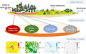
Module 2: Impervious Surface Definition and Significance
- Definition and characteristics of impervious surfaces (IS).
- Environmental impacts of IS: stormwater runoff, urban heat islands, habitat fragmentation.
- Importance of accurate impervious surface mapping for urban planning and environmental management.
- Challenges in IS mapping from remote sensing data (e.g., spectral confusion).
- Case Study: Quantifying the increase in impervious surfaces in a coastal city like Mombasa and its correlation with flash floods.
Module 3: Data Acquisition and Pre-processing for Urban Analysis
- Sources of remote sensing data for urban areas (optical, SAR, LiDAR).
- Data acquisition strategies and mission planning for UAV imagery.
- Radiometric and atmospheric correction techniques for satellite images.
- Geometric correction and image registration for multi-temporal analysis.
- Case Study: Pre-processing Sentinel-2 imagery for urban land cover classification in the greater Tokyo area, addressing cloud cover and atmospheric effects.
Module 4: Traditional Impervious Surface Mapping Techniques
- Pixel-based classification methods: supervised and unsupervised classification.
- Spectral indices for built-up area extraction (e.g., NDBI, IBI).
- Object-Based Image Analysis (OBIA) for impervious surface segmentation.
- Accuracy assessment and validation of classification results (confusion matrix, Kappa coefficient).
- Case Study: Mapping impervious surfaces in Lahore, Pakistan, comparing the accuracy of NDBI-based methods versus supervised classification techniques.
Module 5: Advanced Machine Learning for Urban Mapping
- Introduction to machine learning algorithms in remote sensing
- Feature engineering and selection for improved urban classification.
- Deep learning architectures for semantic segmentation of urban features (e.g., U-Net, FCN).
- Training and validating deep learning models with large urban datasets.
- Case Study: Using a Random Forest classifier to map urban land cover and impervious surfaces in major US cities, such as Los Angeles, demonstrating improved accuracy over traditional methods.
Module 6: Urban Change Detection and Growth Monitoring
- Techniques for detecting urban growth and land use change over time.
- Post-classification comparison, change vector analysis, and image differencing.
- Monitoring urban sprawl and its socio-economic implications.
- Quantifying the rate and direction of urban expansion.
- Case Study: Analyzing urban expansion in Beijing over two decades using time-series Landsat data and change detection algorithms.
Module 7: Specialized Urban Remote Sensing Applications
- Mapping Urban Heat Islands (UHIs) using thermal infrared imagery.
- Remote sensing for stormwater management and hydrological modeling.
- Identifying and assessing urban green spaces and their health.
- Applications in smart city initiatives and urban infrastructure monitoring.
- Case Study: Mapping urban heat island intensity in Phoenix, Arizona, and identifying strategies for mitigation using vegetation indices and thermal band data.
Module 8: Geospatial Platforms and Future Trends
- Introduction to cloud-based geospatial platforms
- Leveraging large-scale datasets and distributed computing for urban analysis.
- Emerging trends in urban remote sensing: AI integration, big data analytics, citizen science.
- Ethical considerations and data privacy in urban remote sensing.
- Case Study: Utilizing Google Earth Engine to monitor impervious surface changes at a regional scale, such as the Yangtze River Delta, demonstrating efficient large-scale analysis.
Training Methodology
- Interactive Lectures: Clear explanations of core concepts with illustrative examples.
- Software Demonstrations: Step-by-step guidance on using industry-standard (e.g., ArcGIS, ENVI) and open-source software (e.g., QGIS, Google Earth Engine Python API).
- Practical Labs: Guided exercises and projects where participants apply learned techniques to real-world datasets.
- Case Study Discussions: Analysis of successful applications and challenges in diverse urban environments.
- Group Activities: Collaborative problem-solving and peer learning sessions.
- Individual Project Work: Opportunity to apply skills to a chosen urban remote sensing challenge.
- Q&A Sessions: Dedicated time for clarification and deeper understanding.
Register as a group from 3 participants for a Discount
Send us an email: [email protected] or call +254724527104
Certification
Upon successful completion of this training, participants will be issued with a globally- recognized certificate.
Tailor-Made Course
We also offer tailor-made courses based on your needs.
Key Notes
a. The participant must be conversant with English.
b. Upon completion of training the participant will be issued with an Authorized Training Certificate
c. Course duration is flexible and the contents can be modified to fit any number of days.
d. The course fee includes facilitation training materials, 2 coffee breaks, buffet lunch and A Certificate upon successful completion of Training.
e. One-year post-training support Consultation and Coaching provided after the course.
f. Payment should be done at least a week before commence of the training, to DATASTAT CONSULTANCY LTD account, as indicated in the invoice so as to enable us prepare better for you.