Training Course on Open-Source Web GIS Development
Training Course on Open-Source Web GIS Development the growing need for skilled professionals who can harness the power of open-source technologies to create innovative geospatial web applications.
Course Overview
Training Course on Open-Source Web GIS Development
Introduction
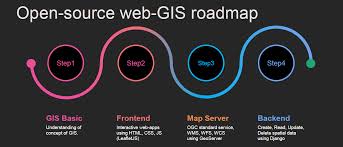
In today's data-driven world, Geographic Information Systems (GIS) are revolutionizing how we understand and interact with spatial data. The demand for dynamic, interactive, and web-based mapping applications is rapidly expanding across diverse sectors. This comprehensive training course focuses on equipping participants with practical skills in Open-Source Web GIS Development, leveraging powerful and flexible libraries like Leaflet and OpenLayers. Participants will gain expertise in building robust and scalable geospatial solutions, enabling them to visualize, analyze, and share critical spatial information effectively.
Training Course on Open-Source Web GIS Development the growing need for skilled professionals who can harness the power of open-source technologies to create innovative geospatial web applications. By mastering Leaflet and OpenLayers, alongside core web development concepts, attendees will be empowered to design and implement custom interactive maps, integrate various spatial data sources, and contribute to the flourishing ecosystem of geo-spatial intelligence. This hands-on training emphasizes practical application, ensuring participants can immediately translate their learning into real-world projects and drive impactful location intelligence within their organizations.
Course Duration
5 days
Course Objectives
By the end of this course, participants will be able to:
- Master foundational Web GIS concepts and principles for modern spatial applications.
- Develop responsive and interactive web maps using Leaflet.js for diverse platforms.
- Implement advanced mapping features with OpenLayers, including complex vector data rendering and custom controls.
- Integrate various geospatial data sources (e.g., GeoJSON, WMS, WFS) into web applications.
- Utilize spatial databases like PostGIS for efficient storage and querying of geographic data.
- Publish and manage geospatial services using GeoServer for scalable data distribution.
- Apply front-end web development skills (HTML5, CSS3, JavaScript ES6+) to enhance User Experience (UX).
- Perform client-side spatial analysis and data visualization techniques for actionable insights.
- Implement real-time data streaming and IoT integration for dynamic map updates.
- Optimize web mapping application performance for large datasets and high traffic.
- Understand cloud-based GIS solutions and deployment strategies for scalability.
- Address web security best practices and data privacy in geospatial applications.
- Build portfolio-ready Web GIS projects demonstrating cutting-edge geospatial technology.
Organizational Benefits
- Reduces reliance on expensive proprietary GIS software licenses by leveraging free and open-source alternatives.
- Empowers teams to develop custom, tailored geospatial solutions addressing unique organizational needs and fostering innovation.
- Enables wider dissemination of spatial information through user-friendly web interfaces, democratizing access to critical data.
- Streamlines workflows for data visualization, analysis, and reporting, leading to more efficient decision-making.
- Provides the capacity to build scalable and adaptable GIS applications that can grow with evolving organizational demands.
- Facilitates seamless data sharing and collaborative mapping projects across departments and with external stakeholders.
- Equips the workforce with in-demand skills in cutting-edge geospatial technologies, enhancing the organization's market position.
- Promotes informed decision-making by providing interactive and dynamic tools for spatial data exploration and analysis.
Target Audience
- GIS Analysts and Specialists.
- Web Developers
- Data Scientists.
- Urban Planners and Architects
- Environmental Scientists and Researchers.
- Public Health Professionals
- Emergency Management and Disaster Response Teams
- Project Managers and Decision-Makers.
Course Outline
Module 1: Introduction to Web GIS and Open-Source Ecosystem
- Fundamentals of GIS and Web GIS
- Overview of Open-Source Geospatial Technologies
- Setting up the Development Environment.
- Basic HTML, CSS, and JavaScript for Web Mapping
- Understanding Spatial Data Formats for the Web
- Case Study: Visualizing global earthquake data from a public GeoJSON API on a basic web map.
Module 2: Mastering Leaflet.js for Interactive Maps
- Leaflet.js Core Concepts.
- Adding Basemaps and Overlay Layers
- Working with Vector Data.
- Interactive Elements
- Leaflet Plugins for Advanced Functionality.
- Case Study: Building an interactive map showing local points of interest with custom markers and pop-ups, integrating a public transit route layer.
Module 3: Deep Dive into OpenLayers for Robust Applications
- OpenLayers Architecture and Core Components
- Advanced Layer Management.
- Styling Features with OpenLayers.
- User Interactions and Controls.
- Working with Projections and Transformations
- Case Study: Developing a regional planning map allowing users to draw proposed development zones and display environmental sensitivity overlays.
Module 4: Spatial Data Management with PostGIS
- Introduction to Relational Databases and PostGIS.
- Setting up PostgreSQL with PostGIS Extension
- Importing and Exporting Spatial Data.
- Spatial SQL Queries.
- Connecting Web Applications to PostGIS
- Case Study: Building a web application to query and display local government data (e.g., property parcels) stored in a PostGIS database.
Module 5: Publishing Geospatial Services with GeoServer
- Understanding OGC Web Services
- Installing and Configuring GeoServer
- Publishing Vector and Raster Data.
- Styling Layers with Styled Layer Descriptors (SLD).
- Integrating GeoServer Services with Leaflet/OpenLayers
- Case Study: Developing a map that displays real-time weather radar (WMS) alongside local flood risk zones (WFS) served by GeoServer.
Module 6: Advanced Client-Side Web GIS Development
- Asynchronous JavaScript and XML (AJAX) for Data Fetching.
- Building Custom Web Components for GIS.
- Responsive Web Design for Mobile GIS.
- Introduction to Front-End Frameworks
- Performance Optimization Techniques
- Case Study: Creating a mobile-friendly public feedback map where users can report issues (e.g., potholes) that are immediately visualized.
Module 7: Spatial Analysis and Data Visualization on the Web
- Client-Side Spatial Analysis Libraries.
- Advanced Data Visualization Techniques.
- Integrating Charts and Graphs with Maps.
- Real-time Data Visualization.
- User Interface (UI) and User Experience (UX) Design for Web GIS.
- Case Study: Developing a dashboard that displays demographic data on a map, with interactive charts updating based on map extent.
Module 8: Deployment, Security, and Future Trends in Web GIS
- Web GIS Application Deployment
- Security Considerations in Web GIS.
- Scalability and Maintenance of Web GIS Applications
- Emerging Trends in Web GIS.
- Project Showcase and Best Practices
- Case Study: Deploying a multi-user web GIS application for collaborative urban planning, ensuring secure access and data versioning.
Training Methodology
This training employs a highly interactive and practical methodology designed for immediate skill acquisition and application.
- Hands-on Labs and Coding Sessions: Over 70% of the course time will be dedicated to practical exercises, coding, and building actual web GIS applications.
- Instructor-Led Demonstrations: Clear and concise demonstrations of concepts and coding techniques.
- Real-World Case Studies: Application of learned skills to solve practical problems across various domains.
- Group Discussions and Collaborative Problem-Solving: Fostering a supportive learning environment and knowledge sharing.
- Project-Based Learning: Participants will work on a culminating project to apply all acquired skills.
- Q&A and Troubleshooting Sessions: Dedicated time for addressing individual challenges and technical queries.
- Access to Online Resources: Course materials, code repositories, and supplementary readings.
Register as a group from 3 participants for a Discount
Send us an email: info@datastatresearch.org or call +254724527104
Certification
Upon successful completion of this training, participants will be issued with a globally- recognized certificate.
Tailor-Made Course
We also offer tailor-made courses based on your needs.
Key Notes
a. The participant must be conversant with English.
b. Upon completion of training the participant will be issued with an Authorized Training Certificate
c. Course duration is flexible and the contents can be modified to fit any number of days.
d. The course fee includes facilitation training materials, 2 coffee breaks, buffet lunch and A Certificate upon successful completion of Training.
e. One-year post-training support Consultation and Coaching provided after the course.
f. Payment should be done at least a week before commence of the training, to DATASTAT CONSULTANCY LTD account, as indicated in the invoice so as to enable us prepare better for you.