Training Course on Object-Based Image Analysis
Training Course on Object-Based Image Analysis provides participants with the theoretical foundations and practical skills to harness the power of OBIA for diverse remote sensing applications, empowering them to conduct advanced spatial analysis and make informed decisions in various industries.
Course Overview
Training Course on Object-Based Image Analysis
Introduction
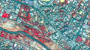
Welcome to a comprehensive training course on Object-Based Image Analysis (OBIA), a cutting-edge geospatial technology revolutionizing how we extract information from high-resolution satellite imagery and aerial photographs. Traditional pixel-based methods often fall short in analyzing complex urban landscapes, intricate ecological systems, or detailed agricultural fields. OBIA, however, transcends these limitations by treating images not as individual pixels, but as meaningful objects or segments, allowing for more sophisticated analysis based on spectral, textural, shape, and contextual properties. Training Course on Object-Based Image Analysis provides participants with the theoretical foundations and practical skills to harness the power of OBIA for diverse remote sensing applications, empowering them to conduct advanced spatial analysis and make informed decisions in various industries.
This intensive program delves into the core principles of image segmentation, feature extraction, and object classification, equipping participants with the expertise to navigate the complexities of geospatial data processing. Through hands-on exercises and real-world case studies, learners will master leading OBIA software, gaining proficiency in workflow automation and algorithm development. Whether you're a seasoned GIS professional or an aspiring remote sensing specialist, this course offers a unique opportunity to elevate your analytical capabilities, unlock deeper insights from imagery, and contribute to data-driven decision-making in a rapidly evolving geospatial intelligence landscape.
Course Duration
5 days
Course Objectives
Upon completion of this course, participants will be able to:
- Comprehend the core concepts, principles, and advantages of Object-Based Image Analysis over traditional pixel-based approaches.
- Apply various segmentation algorithms to delineate meaningful objects from diverse remote sensing data.
- Identify and extract a wide range of spectral, textural, shape, and contextual features for robust object characterization.
- Utilize advanced machine learning and deep learning algorithms for accurate object classification and land cover mapping.
- Design and execute efficient OBIA workflows for specific geospatial applications and analytical tasks.
- Seamlessly integrate OBIA results into Geographic Information Systems (GIS) for further spatial analysis and visualization.
- Apply OBIA techniques for precise object-based change detection in dynamic environments.
- Assess the accuracy and reliability of OBIA classifications using appropriate validation metrics.
- Leverage OBIA for environmental monitoring, including habitat mapping and vegetation analysis.
- Apply OBIA for urban feature extraction, impervious surface mapping, and urban growth monitoring.
- Implement OBIA for precision agriculture, crop health assessment, and yield prediction.
- Employ OBIA for rapid damage assessment and disaster response mapping.
- Understand the latest trends and future directions in GeoAI, deep learning for remote sensing, and cloud-based geospatial analytics.
Organizational Benefits
- Achieve higher classification accuracy for land cover, urban features, and environmental parameters, leading to more reliable insights.
- Automate complex image analysis tasks, reducing manual effort and processing time for large datasets.
- Provide robust, object-level spatial information to support strategic planning, resource management, and policy development.
- Optimize resource allocation and minimize errors by leveraging precise geospatial intelligence, avoiding costly mistakes.
- Stay at the forefront of geospatial technology, offering advanced analytical capabilities and innovative solutions to clients and stakeholders.
- Unlock new possibilities for spatial analysis, enabling the development of novel applications in diverse sectors.
- Gain granular insights into land use, natural resources, and infrastructure for more effective management and conservation efforts.
Target Audience
- GIS Professionals & Analysts
- Remote Sensing Specialists
- Environmental Scientists & Researchers.
- Urban Planners & Developers.
- Agricultural Scientists & Agronomists
- Disaster Management Professionals
- Forestry Professionals.
- Academics & Students
Course Outline
Module 1: Introduction to OBIA and Geospatial Fundamentals
- Overview of Remote Sensing and GIS principles.
- Limitations of traditional pixel-based image analysis.
- Introduction to Object-Based Image Analysis (OBIA): concepts and advantages.
- Understanding image resolution and its impact on OBIA.
- Case Study: Comparing pixel-based vs. OBIA for urban impervious surface mapping.
Module 2: Image Segmentation Techniques
- Principles of image segmentation: creating meaningful objects.
- Various segmentation algorithms: multiresolution segmentation, spectral difference segmentation.
- Optimizing segmentation parameters for different data types and applications.
- Evaluating segmentation quality and fine-tuning results.
- Case Study: Delineating individual tree crowns in a high-resolution forest image.
Module 3: Object Feature Extraction
- Extracting spectral features: mean, standard deviation, band ratios.
- Deriving textural features: GLCM, Haralick features for object characterization.
- Calculating shape features: area, perimeter, compactness, form factor.
- Understanding contextual features: neighborhood relationships, object hierarchy.
- Case Study: Characterizing urban building types based on spectral, shape, and textural properties.
Module 4: Object-Based Classification Methods
- Introduction to supervised and unsupervised classification in OBIA.
- Nearest Neighbor (NN), Support Vector Machine (SVM), and Random Forest classifiers.
- Developing rule sets and decision trees for object classification.
- Integrating expert knowledge and ontology-driven classification.
- Case Study: Classifying land cover types (e.g., forest, water, urban) using multi-spectral imagery and a rule-based approach.
Module 5: Advanced OBIA Workflows and Automation
- Building efficient OBIA workflows for complex projects.
- Scripting and workflow automation using popular OBIA software platforms.
- Implementing iterative refinement and multi-scale analysis.
- Handling big geospatial data with OBIA.
- Case Study: Automating the detection and mapping of informal settlements from time-series satellite imagery.
Module 6: OBIA for Change Detection
- Principles of object-based change detection.
- Techniques for identifying changes in land cover and land use over time.
- Post-classification comparison and object-based image differencing.
- Quantifying and visualizing detected changes.
- Case Study: Monitoring coastal erosion by analyzing shoreline changes using multi-temporal OBIA.
Module 7: OBIA Applications in Environmental & Urban Planning
- Applying OBIA for environmental monitoring: wetlands mapping, deforestation.
- Utilizing OBIA for urban planning: urban sprawl analysis, infrastructure mapping.
- Integrating LiDAR data with OBIA for 3D object extraction.
- Case Study: Assessing forest health and disease outbreaks using OBIA on drone imagery.
- Case Study: Mapping and analyzing urban heat islands from thermal imagery.
Module 8: Emerging Trends and Future of OBIA
- Introduction to GeoAI: Deep Learning and Machine Learning advancements in OBIA.
- Convolutional Neural Networks (CNNs) and U-Net architectures for object detection and segmentation.
- Cloud-based OBIA platforms and big data analytics.
- Ethical considerations and challenges in AI-driven geospatial analysis.
- Case Study: Using deep learning with OBIA to automatically detect and classify vehicles in high-resolution aerial images.
Training Methodology
This course employs a blended learning approach to maximize participant engagement and skill acquisition. The methodology includes:
- Interactive Lectures: Clear and concise theoretical explanations of OBIA concepts.
- Hands-on Software Exercises: Practical sessions using industry-leading OBIA software (e.g., eCognition, ArcGIS Pro with OBIA tools, open-source alternatives).
- Real-world Case Studies: Application of learned techniques to diverse scenarios and datasets, fostering problem-solving skills.
- Group Discussions & Problem-Solving: Collaborative learning and exchange of ideas among participants.
- Practical Demonstrations: Live demonstrations of complex OBIA workflows and advanced techniques.
- Q&A Sessions: Dedicated time for participants to ask questions and clarify doubts with expert instructors.
- Project-Based Learning: Participants will work on a culminating project applying OBIA to a chosen problem.
Register as a group from 3 participants for a Discount
Send us an email: info@datastatresearch.org or call +254724527104
Certification
Upon successful completion of this training, participants will be issued with a globally- recognized certificate.
Tailor-Made Course
We also offer tailor-made courses based on your needs.
Key Notes
a. The participant must be conversant with English.
b. Upon completion of training the participant will be issued with an Authorized Training Certificate
c. Course duration is flexible and the contents can be modified to fit any number of days.
d. The course fee includes facilitation training materials, 2 coffee breaks, buffet lunch and A Certificate upon successful completion of Training.
e. One-year post-training support Consultation and Coaching provided after the course.
f. Payment should be done at least a week before commence of the training, to DATASTAT CONSULTANCY LTD account, as indicated in the invoice so as to enable us prepare better for you.