Training Course on Metaverse and Spatial Computing for GIS Professionals
Training Course on Metaverse and Spatial Computing for GIS Professionals is specifically designed to equip GIS professionals with the advanced skills needed to navigate and contribute to the immersive web.
Course Overview
Training Course on Metaverse and Spatial Computing for GIS Professionals
Introduction
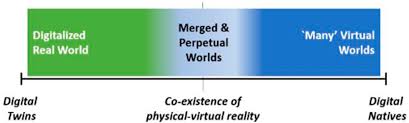
The rapid evolution of the Metaverse and Spatial Computing is poised to revolutionize how we interact with digital information and the physical world. For GIS Professionals, this convergence offers unprecedented opportunities to create immersive, data-rich environments and unlock new dimensions of spatial analysis. This training course delves into the foundational concepts, cutting-edge tools, and practical applications of these transformative technologies, empowering geospatial experts to lead the charge in building the next generation of digital realities. We'll explore how geospatial data, 3D modeling, virtual reality (VR), augmented reality (AR), and digital twins are converging to form intelligent, interactive virtual spaces, offering a powerful paradigm for decision-making, planning, and visualization across diverse industries.
Training Course on Metaverse and Spatial Computing for GIS Professionals is specifically designed to equip GIS professionals with the advanced skills needed to navigate and contribute to the immersive web. Participants will gain hands-on experience with platforms and techniques for geospatial visualization, real-time data integration, and spatial analytics within virtual environments. By understanding the interplay between physical and digital realms, attendees will be able to leverage their existing GIS expertise to design, develop, and manage compelling spatial computing applications, transforming raw data into actionable insights within dynamic, interactive metaverses.
Course Duration
5 days
Course Objectives
By the end of this training course, participants will be able to:
- Define and differentiate between the Metaverse, Spatial Computing, Virtual Reality (VR), Augmented Reality (AR), and Mixed Reality (MR).
- Understand the foundational role of Geospatial Information Systems (GIS) in building and enriching metaverse environments.
- Master techniques for 3D geospatial data acquisition, modeling, and optimization for immersive platforms.
- Apply principles of digital twin creation for real-world assets and environments within a spatial computing context.
- Utilize tools and platforms for real-time spatial data integration and visualization in virtual worlds.
- Develop interactive geospatial applications using scripting and development frameworks relevant to the Metaverse.
- Conduct advanced spatial analytics within immersive 3D environments for enhanced decision-making.
- Explore the ethical, privacy, and security considerations associated with metaverse data and spatial identity.
- Design and implement user experiences (UX) for intuitive interaction within spatial computing applications.
- Evaluate emerging hardware and software trends in VR, AR, and spatial computing for GIS applications.
- Identify and articulate business opportunities and use cases for geospatial intelligence in the Metaverse.
- Collaborate effectively in distributed virtual environments for joint geospatial projects.
- Formulate strategies for integrating AI and blockchain technologies with geospatial data in spatial computing.
Organizational Benefits
- Leverage immersive 3D visualizations and real-time data to make more informed and contextualized decisions.
- Facilitate remote, interactive collaboration on complex geospatial projects, breaking down geographical barriers.
- Simulate real-world scenarios in virtual environments for planning, training, and risk assessment, minimizing physical expenditures and potential hazards.
- Foster a culture of innovation by enabling employees to explore new applications and solutions within the cutting-edge fields of Metaverse and Spatial Computing.
- Position the organization at the forefront of technological advancement, attracting top talent and new business opportunities in the evolving digital landscape.
- Create digital twins of physical assets and infrastructure to monitor, manage, and optimize operations more efficiently.
- Communicate complex spatial information more effectively to diverse stakeholders through immersive and interactive experiences.
Target Audience
- GIS Analysts and Specialists.
- Urban Planners and Architects.
- Environmental Scientists and Conservationists.
- Remote Sensing Professionals.
- Developers and Programmers.
- Data Scientists.
- Emergency Management and Disaster Response Professionals.
- Academics and Researchers.
Course Outline
Module 1: Foundations of Metaverse and Spatial Computing
- Introduction to the Metaverse: Concepts, history, and the vision of a persistent, interconnected virtual world.
- Defining Spatial Computing: Bridging the physical and digital, key components (AR, VR, MR, XR).
- The Role of Geospatial Data in the Metaverse: Why GIS is foundational for creating realistic and functional virtual environments.
- Hardware and Software Landscape: Overview of current VR headsets, AR devices, and relevant development platforms.
- Case Study: Decentraland's Geospatial Economy: Exploring how real-world land parcels are represented and traded as NFTs in a virtual world.
Module 2: 3D Geospatial Data Acquisition and Modeling
- Techniques for 3D Data Capture: Photogrammetry, LiDAR scanning, and traditional surveying for dense point clouds and meshes.
- Processing and Optimizing 3D Geospatial Data: Cleaning, simplifying, and texturing models for efficient rendering in immersive environments.
- Introduction to 3D Modeling Software: Blender, SketchUp, and their integration with GIS data.
- Georeferencing and Coordinate Systems in 3D: Ensuring spatial accuracy and alignment of virtual assets.
- Case Study: Esri's ArcGIS CityEngine for Urban Digital Twins: Creating realistic 3D city models from 2D GIS data and procedural rules.
Module 3: Digital Twins and Real-Time Data Integration
- Concepts of Digital Twins: Creating virtual replicas of physical assets, systems, or environments.
- Integrating Real-Time Sensor Data (IoT): Connecting live data streams to digital twins for dynamic representations.
- From GIS to Digital Twin: Methodologies for building geospatial digital twins for infrastructure, buildings, and natural environments.
- Data Streaming and Visualization: Techniques for efficiently rendering large datasets and real-time updates in immersive platforms.
- Case Study: Siemens' Digital Twin of Singapore's Tuas Port: Optimizing port operations through a comprehensive digital replica with real-time data.
Module 4: Immersive Visualization and User Experience (UX)
- Principles of Immersive Visualization: Best practices for displaying geospatial information in VR/AR for clarity and engagement.
- Designing Spatial User Interfaces (SUIs): Interaction paradigms for navigation, selection, and data manipulation in 3D environments.
- Haptics and Spatial Audio: Enhancing immersion through tactile feedback and realistic soundscapes.
- Avatar Design and Representation: Creating digital identities for users within collaborative metaverse spaces.
- Case Study: Virtual Tours of Historical Sites with Photogrammetry and VR: Recreating ancient ruins or historical cities for immersive exploration.
Module 5: Developing Spatial Computing Applications with GIS
- Introduction to Game Engines for Geospatial Applications: Unity 3D and Unreal Engine as development platforms.
- Scripting for Interactive Experiences: C# (Unity) or Blueprint/C++ (Unreal) for geospatial interactions.
- Integrating GIS SDKs/APIs: Leveraging ArcGIS Maps SDK for Unity/Unreal or other geospatial libraries.
- Building Multi-User Environments: Enabling collaborative experiences within geospatial metaverse applications.
- Case Study: NVIDIA Omniverse for Industrial Digital Twins: Collaborative platform for designing and simulating complex industrial facilities.
Module 6: Advanced Spatial Analytics in Immersive Environments
- Performing Spatial Queries in 3D: Analyzing relationships between objects in a volumetric space.
- Network Analysis in Virtual Worlds: Pathfinding, service areas, and flow analysis in simulated environments.
- Visibility and Line-of-Sight Analysis: Understanding spatial intervisibility in 3D urban or natural landscapes.
- Environmental Simulation and Modeling: Integrating climate models, propagation models, and other simulations into immersive environments.
- Case Study: Urban Planning Simulation in VR: Using spatial computing to visualize the impact of new developments on urban environments and conduct analyses.
Module 7: Emerging Trends: AI, Blockchain, and Interoperability
- AI in Spatial Computing: Computer vision for scene understanding, generative AI for content creation, and intelligent agents for dynamic environments.
- Blockchain and Decentralized Geospatial Data: Ownership, security, and smart contracts for spatial assets.
- NFTs and Digital Land: Understanding the economic models and implications of digital real estate.
- Interoperability and Standards: OGC, glTF, USDZ, and the push for seamless data exchange across metaverse platforms.
- Case Study: Google's Project Starline: Leveraging advanced AI and spatial computing for hyper-realistic 3D video conferencing.
Module 8: Real-World Applications and Future Outlook
- Metaverse for Urban Planning and Smart Cities: Engaging citizens, simulating infrastructure changes, and managing urban assets.
- Spatial Computing in Environmental Monitoring and Disaster Response: Real-time situational awareness, predictive modeling, and training simulations.
- Virtual Tourism and Cultural Heritage: Recreating historical sites and natural wonders for global access.
- Future of Geospatial Professions: New roles, skill sets, and career opportunities in the evolving spatial computing landscape.
- Case Study: Microsoft Mesh for Enterprise Collaboration: Enabling remote teams to collaborate in shared 3D spaces with spatial data overlays.
Training Methodology
This training course will employ a blended learning approach, combining theoretical knowledge with extensive practical application. The methodology will include:
- Interactive Lectures and Presentations: Core concepts and principles will be introduced through engaging lectures with visual aids.
- Hands-on Software Workshops: Participants will gain practical experience with industry-standard software (e.g., Unity, Unreal Engine, ArcGIS Pro, Blender) through guided exercises.
- Live Demonstrations: Expert instructors will showcase real-world applications and advanced techniques.
- Case Study Analysis: In-depth examination of successful implementations of Metaverse and Spatial Computing in GIS, fostering critical thinking and problem-solving.
- Group Discussions and Collaborative Projects: Encouraging peer-to-peer learning, knowledge sharing, and teamwork on practical scenarios.
- Individual Capstone Project: Participants will apply learned skills to develop a small-scale spatial computing application or prototype.
- Q&A Sessions: Dedicated time for participants to clarify doubts and engage with instructors.
Register as a group from 3 participants for a Discount
Send us an email: info@datastatresearch.org or call +254724527104
Certification
Upon successful completion of this training, participants will be issued with a globally- recognized certificate.
Tailor-Made Course
We also offer tailor-made courses based on your needs.
Key Notes
a. The participant must be conversant with English.
b. Upon completion of training the participant will be issued with an Authorized Training Certificate
c. Course duration is flexible and the contents can be modified to fit any number of days.
d. The course fee includes facilitation training materials, 2 coffee breaks, buffet lunch and A Certificate upon successful completion of Training.
e. One-year post-training support Consultation and Coaching provided after the course.
f. Payment should be done at least a week before commence of the training, to DATASTAT CONSULTANCY LTD account, as indicated in the invoice so as to enable us prepare better for you.