Training Course on Mastering Geodesy, Projections, and Coordinate Systems
Training Course on Mastering Geodesy, Projections, and Coordinate Systems is meticulously designed to equip geospatial professionals, engineers, and scientists with
Course Overview
Training Course on Mastering Geodesy, Projections, and Coordinate Systems
Introduction
Training Course on Mastering Geodesy, Projections, and Coordinate Systems is meticulously designed to equip geospatial professionals, engineers, and scientists with a profound understanding of geodesy, map projections, and coordinate systems. In an increasingly data-driven world, precise spatial data infrastructure and accurate georeferencing are paramount for effective decision-making across diverse industries. This program dives deep into the theoretical underpinnings and practical applications, empowering participants to confidently manage, transform, and analyze geospatial data with unparalleled accuracy and efficiency.
The course emphasizes practical, hands-on learning, leveraging industry-standard software and real-world case studies to solidify concepts. Participants will gain expertise in selecting appropriate reference systems, performing seamless datum transformations, and mitigating spatial distortion inherent in mapping. By mastering these fundamental geospatial principles, attendees will enhance their ability to contribute to critical projects ranging from urban planning and environmental monitoring to precision agriculture and autonomous navigation, ensuring robust and reliable spatial solutions.
Course Duration
5 days
Course Objectives
- Comprehend the fundamental principles of geodesy, including the Earth's shape, gravity field, and geoid models.
- Differentiate between various geodetic datums (e.g., WGS84, NAD83) and their implications for spatial accuracy.
- Master the theory and application of different map projections (e.g., UTM, Lambert Conformal Conic, Mercator) and their distortions.
- Effectively perform coordinate transformations and datum conversions between various coordinate reference systems (CRS).
- Understand the concept of scale factor and angular distortion in projected coordinates.
- Utilize geospatial software for defining, reprojecting, and analyzing spatial data.
- Identify and resolve common georeferencing issues and data misalignment problems.
- Apply best practices for spatial data management and quality control.
- Gain proficiency in interpreting metadata related to coordinate systems and projections.
- Understand the role of Global Navigation Satellite Systems (GNSS) in establishing precise coordinates.
- Explore the impact of tectonic motion on coordinate values and datum realizations.
- Develop critical thinking skills for selecting the most appropriate CRS for specific geospatial projects.
- Prepare for advanced topics in spatial analysis and geospatial modeling.
Organizational Benefits
- Reduce errors and improve the reliability of spatial data, leading to more informed decisions.
- Facilitate seamless data exchange and integration across different systems and stakeholders.
- Minimize rework and avoid costly mistakes associated with incorrect georeferencing.
- Streamline geospatial workflows and optimize data processing.
- Reduce legal and operational risks associated with inaccurate spatial information.
- Develop a highly skilled workforce capable of tackling complex geospatial challenges.
- Ensure adherence to industry standards and regulatory requirements for spatial data.
- Foster an environment that supports advanced spatial analysis and technological adoption.
Target Audience
- GIS Analysts and Specialists
- Surveyors and Cartographers.
- Civil and Environmental Engineers
- Urban Planners and Developers development.
- Geospatial Technologists and Developers
- Researchers and Academics
- Data Scientists.
- Anyone using GPS/GNSS data.
Course Outline
Module 1: Fundamentals of Geodesy and Earth Models
- Defining Geodesy: The science of measuring and representing the Earth's shape, orientation, and gravity field.
- The Earth's Shape: Sphere, Ellipsoid, and Geoid – understanding their differences and applications.
- Reference Ellipsoids and Geodetic Datums: Global vs. local datums
- Gravity Field and Geoid Undulations: Importance for vertical datums and height systems.
- Introduction to GNSS and its role in modern geodesy.
- Case Study: Analyzing discrepancies in elevation data from different sources (GPS vs. traditional leveling) due to varying vertical datums and geoid models.
Module 2: Geographic Coordinate Systems (GCS)
- Latitude and Longitude: Principles and units of measurement
- Prime Meridian and Equator: Defining the origin of a GCS.
- Angular vs. Linear Units: Understanding the inherent challenges of measuring distances in a GCS.
- Horizontal Datums and their parameters: Origin, orientation, and reference ellipsoid.
- Representing points in 3D space.
- Case Study: Comparing coordinate values for the same location using WGS84 and a local datum, highlighting the impact of datum shifts on positional accuracy.
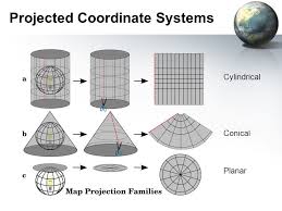
Module 3: Understanding Map Projections
- The Need for Projections: Transforming the 3D Earth to a 2D plane.
- Types of Developable Surfaces: Cylindrical, Conic, and Azimuthal projections.
- Projection Properties: Conformal (shape), Equal-Area, Equidistant, True-Direction.
- Distortion Analysis: Visualizing and quantifying distortions in various projections.
- Selecting the Right Projection: Factors influencing projection choice
- Case Study: Examining the distortions in area and shape when comparing a world map projected using Mercator vs. a global equal-area projection like Mollweide, demonstrating their suitability for different thematic maps.
Module 4: Common Map Projections and Their Applications
- Universal Transverse Mercator (UTM): Zones, central meridian, false easting/northing.
- State Plane Coordinate Systems (SPCS): Design and application in various regions.
- Lambert Conformal Conic: Ideal for mid-latitude regions with east-west extent.
- Albers Equal-Area Conic: Preserving area for thematic mapping.
- Other common projections
- Case Study: A land development project spanning multiple UTM zones, requiring careful management of coordinates and understanding the need for consistent projection across datasets.
Module 5: Coordinate Transformations and Reprojection
- Geographic to Projected Transformations: The mathematical basis.
- Datum Transformations: Different methods
- On-the-Fly vs. Permanent Reprojection: When and how to apply each.
- Understanding Transformation Parameters and their accuracy.
- Practical exercises using GIS software for reprojection.
- Case Study: Integrating legacy survey data (NAD27) with modern GPS data (WGS84) for a construction project, demonstrating the process and importance of accurate datum transformation.
Module 6: Vertical Datums and Height Systems
- Orthometric Heights vs. Ellipsoidal Heights: Understanding the difference.
- Geoid Models and their role in converting ellipsoidal heights to orthometric heights.
- Tidal Datums and their significance for coastal mapping.
- International Terrestrial Reference Frame (ITRF) and its evolution.
- Vertical Datum Transformations and their challenges.
- Case Study: A flood mapping project requiring precise vertical accuracy, highlighting the necessity of using the correct geoid model and vertical datum for accurate inundation modeling.
Module 7: Practical Applications and Troubleshooting
- Identifying and correcting common coordinate system errors
- Working with heterogeneous spatial data from multiple sources.
- Best practices for spatial data documentation and metadata creation.
- Quality control and validation of georeferenced data.
- Advanced tools and techniques for spatial data harmonization.
- Case Study: Diagnosing and resolving a significant spatial misalignment in a large-scale infrastructure project due to incorrect datum application in some datasets.
Module 8: Emerging Trends and Future of Geodesy
- Real-time Kinematic (RTK) and Post-Processed Kinematic (PPK) GNSS.
- Leveraging Cloud-based Geospatial Platforms for data management and analysis.
- 3D Geodesy and its applications in smart cities and BIM.
- Machine Learning and AI in Georeferencing and spatial data processing.
- The role of geodesy in autonomous vehicles and precision agriculture.
- Case Study: Discussing the challenges and benefits of using real-time precise positioning for autonomous drone surveys in difficult terrains, emphasizing the critical role of accurate coordinate systems.
Training Methodology
This course employs a blended learning approach combining:
- Interactive Lectures: Engaging presentations to explain core concepts.
- Hands-on Software Exercises: Practical sessions using industry-standard GIS software (e.g., ArcGIS Pro, QGIS, Global Mapper) for real-world application.
- Demonstrations: Live walkthroughs of complex procedures and problem-solving techniques.
- Case Studies: In-depth analysis of real-world scenarios to illustrate practical challenges and solutions.
- Group Discussions: Facilitating knowledge sharing and collaborative problem-solving.
- Quizzes and Assessments: To reinforce learning and gauge understanding.
- Practical Assignments: To apply learned skills to individual projects.
- Q&A Sessions: Dedicated time for addressing participant queries and clarifying concepts.
Register as a group from 3 participants for a Discount
Send us an email: info@datastatresearch.org or call +254724527104
Certification
Upon successful completion of this training, participants will be issued with a globally- recognized certificate.
Tailor-Made Course
We also offer tailor-made courses based on your needs.
Key Notes
a. The participant must be conversant with English.
b. Upon completion of training the participant will be issued with an Authorized Training Certificate
c. Course duration is flexible and the contents can be modified to fit any number of days.
d. The course fee includes facilitation training materials, 2 coffee breaks, buffet lunch and A Certificate upon successful completion of Training.
e. One-year post-training support Consultation and Coaching provided after the course.
f. Payment should be done at least a week before commence of the training, to DATASTAT CONSULTANCY LTD account, as indicated in the invoice so as to enable us prepare better for you.