Training Course on GIS for Precision Agriculture and Smart Farming
Training Course on GIS for Precision Agriculture and Smart Farming is designed for professionals seeking to elevate their expertise beyond fundamental GIS concepts.
Course Overview
Training Course on GIS for Precision Agriculture and Smart Farming
Introduction
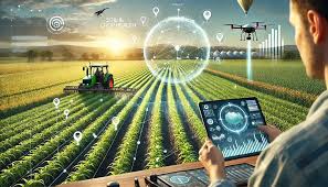
The agricultural landscape is undergoing a profound transformation driven by technological innovation. Geographic Information Systems (GIS) stand at the forefront of this revolution, empowering farmers and agribusinesses with unprecedented capabilities for data-driven decision-making. This advanced training course delves into the sophisticated applications of GIS, remote sensing, and geospatial analytics to optimize agricultural practices, enhance resource efficiency, and champion sustainable farming in the era of smart agriculture. Participants will gain mastery over cutting-edge tools and techniques for precision crop management, yield optimization, and environmental stewardship.
Training Course on GIS for Precision Agriculture and Smart Farming is designed for professionals seeking to elevate their expertise beyond fundamental GIS concepts. We will explore advanced spatial modeling, the integration of IoT data, AI-driven insights, and drone technology for real-time farm monitoring and intelligent interventions. Through practical case studies and hands-on exercises, attendees will develop the skills to implement robust precision agriculture solutions, fostering increased profitability, reduced environmental impact, and enhanced food security through truly smart farming systems.
Course Duration
10 days
Course Objectives
Upon completion of this course, participants will be able to:
- Master Advanced Geospatial Analytics for agricultural data interpretation and problem-solving.
- Integrate Multi-Source Agricultural Data for holistic farm intelligence.
- Develop AI-Powered Predictive Models for crop yield forecasting and disease detection.
- Implement Variable Rate Technology (VRT) solutions for optimized input application
- Utilize Drone and UAV Data Processing for high-resolution imagery and precise field mapping.
- Design and Manage IoT Sensor Networks for real-time environmental and crop monitoring.
- Apply Machine Learning Algorithms for automated anomaly detection and precision irrigation scheduling.
- Conduct Advanced Soil Health Mapping and nutrient management using spatial interpolation techniques.
- Analyze Climate Change Impacts on agriculture and develop adaptation strategies using GIS.
- Formulate Data-Driven Farm Management Plans for enhanced profitability and sustainability.
- Leverage Cloud-Based GIS Platforms for collaborative and scalable precision agriculture initiatives.
- Perform Spatial-Temporal Analysis to understand dynamic agricultural processes and trends.
- Design and Evaluate Smart Irrigation Systems based on precise water demand mapping.
Organizational Benefits
- Optimizing resource use and crop management leads to higher yields and reduced operational costs.
- Minimizing waste of water, fertilizers, and pesticides.
- Data-driven insights enable more accurate forecasting and strategic planning.
- Promoting sustainable practices through targeted interventions and minimized chemical application.
- Proactive identification and mitigation of issues like pest outbreaks and drought.
- Leveraging cutting-edge AgTech innovations for market leadership.
- Meeting environmental standards and promoting sustainable agriculture.
- Fostering a culture of continuous improvement and technological adoption.
- Better yield prediction and planning for efficient logistics.
- Early detection of stress and diseases, leading to timely interventions.
Target Audience
- Agricultural Researchers and Agronomists
- GIS and Remote Sensing Professionals
- Farm Managers and Agribusiness Professionals
- Precision Agriculture Consultants
- Data Scientists and Analysts in the Agricultural Sector
- Government Officials and Policymakers
- Environmental Scientists and Conservationists
- Technology Developers and Entrepreneurs
Course Outline
Module 1: Advanced GIS Foundations for Smart Farming
- Deep dive into geospatial data models for agriculture.
- Advanced coordinate systems, projections, and transformations for precision.
- Geodatabase design and management for large-scale agricultural datasets.
- Spatial SQL for complex data queries and manipulation.
- Case Study: Designing a comprehensive farm geodatabase for a multi-crop enterprise to track soil, yield, and input data.
Module 2: Remote Sensing for High-Resolution Agricultural Insights
- Principles of hyperspectral and multispectral imagery in agriculture.
- Advanced image pre-processing techniques
- Spectral indices beyond NDVI (e.g., NDRE, EVI) for nuanced crop health assessment.
- LiDAR data processing for terrain modeling and plant height analysis.
- Case Study: Utilizing hyperspectral imagery to identify specific nutrient deficiencies in vineyards and plan targeted fertilization.
Module 3: Drone and UAV Applications in Precision Agriculture
- UAV flight planning and data acquisition for large agricultural areas.
- Photogrammetry and SfM (Structure from Motion) for generating high-resolution orthomosaics and 3D models.
- Thermal and multispectral drone imagery analysis for water stress and disease detection.
- Legal and ethical considerations for commercial drone operations in agriculture.
- Case Study: Implementing a drone-based scouting program for early detection of pest infestations in a cornfield, reducing pesticide use.
Module 4: IoT and Sensor Integration for Real-Time Monitoring
- Architectures and protocols for agricultural IoT networks (LoRaWAN, Zigbee, cellular).
- Deployment and calibration of various smart sensors (soil moisture, temperature, pH, nutrient).
- Real-time data streaming and dashboard visualization for immediate farm insights.
- Edge computing and data processing at the sensor level for efficiency.
- Case Study: Developing an IoT-enabled smart irrigation system for an orchard, dynamically adjusting water delivery based on real-time soil moisture.
Module 5: Advanced Spatial Statistics and Geostatistics
- Exploratory spatial data analysis (ESDA) for identifying spatial patterns.
- Variography and kriging for interpolating soil and yield data.
- Regression analysis with spatial components for understanding agricultural drivers.
- Cluster analysis and hot spot analysis for identifying problem areas.
- Case Study: Using kriging to create highly accurate fertilizer prescription maps based on limited soil sample data.
Module 6: Machine Learning and AI in Precision Agriculture
- Introduction to supervised and unsupervised learning algorithms for agricultural data.
- Predictive modeling for crop yield, disease outbreaks, and market trends.
- Image classification and object detection using deep learning for crop counting and weed identification.
- Reinforcement learning for optimizing autonomous farm machinery.
- Case Study: Building an AI model to predict potato blight incidence based on historical weather, soil, and disease data.
Module 7: Variable Rate Technology (VRT) and Automated Application
- Principles of VRT for seeding, fertilization, and pest control.
- Creating prescription maps using GIS and spatial analysis.
- Integration with farm machinery and implement control systems.
- Optimizing VRT strategies for economic and environmental benefits.
- Case Study: Implementing a variable rate nitrogen application program in wheat fields, achieving significant cost savings and reduced runoff.
Module 8: Precision Irrigation and Water Management
- Mapping water availability and demand using GIS and remote sensing.
- Designing and optimizing drip, sprinkler, and pivot irrigation systems.
- Modeling water stress and optimizing irrigation schedules.
- Integration with weather data and evapotranspiration models.
- Case Study: Developing a precision irrigation plan for a rice paddy, minimizing water waste while maximizing yield.
Module 9: Soil Health and Nutrient Management through GIS
- Advanced soil mapping techniques (EC, organic matter, cation exchange capacity).
- Spatial analysis of soil nutrient levels and nutrient budgeting.
- Strategies for optimizing fertilizer application and minimizing nutrient loss.
- GIS for monitoring soil erosion and implementing conservation practices.
- Case Study: Creating a detailed soil amendment strategy for a degraded pasture, using GIS to guide lime and organic matter application.
Module 10: Crop Yield Mapping and Analysis
- Collecting and processing yield monitor data.
- Creating and interpreting yield maps to identify high and low productivity zones.
- Correlation analysis between yield data and various environmental factors.
- Using yield maps for future decision-making and performance benchmarking.
- Case Study: Analyzing five years of corn yield data to understand field variability and optimize hybrid selection for different zones.
Module 11: Pest and Disease Surveillance and Management
- Spatial modeling of pest and disease spread using GIS.
- Integrating remote sensing and drone data for early detection of outbreaks.
- Designing targeted pesticide application zones based on risk maps.
- Forecasting pest and disease pressure using environmental data.
- Case Study: Developing a real-time GIS dashboard for monitoring fall armyworm infestation in a large-scale maize farm, enabling rapid response.
Module 12: Livestock and Pasture Management with GIS
- Mapping grazing patterns and pasture health.
- Optimizing livestock distribution and rotational grazing.
- Monitoring water points and fencing infrastructure.
- Integrating GPS tracking data for animal welfare and management.
- Case Study: Using GIS to optimize pasture rotation for a cattle ranch, improving forage utilization and soil health.
Module 13: Climate Change Adaptation and Resilience
- Assessing climate change impacts on agricultural suitability and productivity.
- Modeling drought risk and designing resilient farming systems.
- GIS for identifying suitable areas for new crop varieties under changing climates.
- Carbon sequestration monitoring and carbon farming initiatives.
- Case Study: Identifying climate-resilient crop alternatives for a region experiencing increased drought frequency using climate models and GIS.
Module 14: Economic Analysis and Farm Planning
- Cost-benefit analysis of precision agriculture technologies.
- Optimizing farm layouts and field boundaries for efficiency.
- GIS for land valuation, acquisition, and farm expansion planning.
- Developing enterprise budgets and financial models incorporating spatial data.
- Case Study: Conducting an economic feasibility study for adopting precision seeding technology on a large-scale soybean farm.
Module 15: Future Trends and Emerging Technologies in Smart Farming
- Blockchain for agricultural traceability and supply chain transparency.
- Digital Twins for comprehensive virtual farm simulation and optimization.
- Robotics and autonomous vehicles in agriculture and their GIS integration.
- Advanced data visualization and augmented reality in farm management.
- Case Study: Exploring the potential of a "Digital Twin" for a????, integrating all aspects of farm operations for real-time management and predictive maintenance.
Training Methodology
This advanced training course will employ a highly interactive and practical methodology, blending theoretical concepts with hands-on application. The approach includes:
- Expert-Led Lectures and Discussions
- Hands-on Software Exercises
- Real-World Case Studies and Problem-Solving
- Data-Driven Simulations
- Group Projects and Collaborative Workshops.
- Field Data Collection Techniques.
- Q&A Sessions and Interactive Troubleshooting.
- Access to Online Resources
Register as a group from 3 participants for a Discount
Send us an email: info@datastatresearch.org or call +254724527104
Certification
Upon successful completion of this training, participants will be issued with a globally- recognized certificate.
Tailor-Made Course
We also offer tailor-made courses based on your needs.
Key Notes
a. The participant must be conversant with English.
b. Upon completion of training the participant will be issued with an Authorized Training Certificate
c. Course duration is flexible and the contents can be modified to fit any number of days.
d. The course fee includes facilitation training materials, 2 coffee breaks, buffet lunch and A Certificate upon successful completion of Training.
e. One-year post-training support Consultation and Coaching provided after the course.
f. Payment should be done at least a week before commence of the training, to DATASTAT CONSULTANCY LTD account, as indicated in the invoice so as to enable us prepare better for you.
Training Course on GIS for Precision Agriculture and Smart Farming
Introduction
The agricultural landscape is undergoing a profound transformation driven by technological innovation. Geographic Information Systems (GIS) stand at the forefront of this revolution, empowering farmers and agribusinesses with unprecedented capabilities for data-driven decision-making. This advanced training course delves into the sophisticated applications of GIS, remote sensing, and geospatial analytics to optimize agricultural practices, enhance resource efficiency, and champion sustainable farming in the era of smart agriculture. Participants will gain mastery over cutting-edge tools and techniques for precision crop management, yield optimization, and environmental stewardship.
Training Course on GIS for Precision Agriculture and Smart Farming is designed for professionals seeking to elevate their expertise beyond fundamental GIS concepts. We will explore advanced spatial modeling, the integration of IoT data, AI-driven insights, and drone technology for real-time farm monitoring and intelligent interventions. Through practical case studies and hands-on exercises, attendees will develop the skills to implement robust precision agriculture solutions, fostering increased profitability, reduced environmental impact, and enhanced food security through truly smart farming systems.
Course Duration
10 days
Course Objectives
Upon completion of this course, participants will be able to:
- Master Advanced Geospatial Analytics for agricultural data interpretation and problem-solving.
- Integrate Multi-Source Agricultural Data for holistic farm intelligence.
- Develop AI-Powered Predictive Models for crop yield forecasting and disease detection.
- Implement Variable Rate Technology (VRT) solutions for optimized input application
- Utilize Drone and UAV Data Processing for high-resolution imagery and precise field mapping.
- Design and Manage IoT Sensor Networks for real-time environmental and crop monitoring.
- Apply Machine Learning Algorithms for automated anomaly detection and precision irrigation scheduling.
- Conduct Advanced Soil Health Mapping and nutrient management using spatial interpolation techniques.
- Analyze Climate Change Impacts on agriculture and develop adaptation strategies using GIS.
- Formulate Data-Driven Farm Management Plans for enhanced profitability and sustainability.
- Leverage Cloud-Based GIS Platforms for collaborative and scalable precision agriculture initiatives.
- Perform Spatial-Temporal Analysis to understand dynamic agricultural processes and trends.
- Design and Evaluate Smart Irrigation Systems based on precise water demand mapping.
Organizational Benefits
- Optimizing resource use and crop management leads to higher yields and reduced operational costs.
- Minimizing waste of water, fertilizers, and pesticides.
- Data-driven insights enable more accurate forecasting and strategic planning.
- Promoting sustainable practices through targeted interventions and minimized chemical application.
- Proactive identification and mitigation of issues like pest outbreaks and drought.
- Leveraging cutting-edge AgTech innovations for market leadership.
- Meeting environmental standards and promoting sustainable agriculture.
- Fostering a culture of continuous improvement and technological adoption.
- Better yield prediction and planning for efficient logistics.
- Early detection of stress and diseases, leading to timely interventions.
Target Audience
- Agricultural Researchers and Agronomists
- GIS and Remote Sensing Professionals
- Farm Managers and Agribusiness Professionals
- Precision Agriculture Consultants
- Data Scientists and Analysts in the Agricultural Sector
- Government Officials and Policymakers
- Environmental Scientists and Conservationists
- Technology Developers and Entrepreneurs
Course Outline
Module 1: Advanced GIS Foundations for Smart Farming
- Deep dive into geospatial data models for agriculture.
- Advanced coordinate systems, projections, and transformations for precision.
- Geodatabase design and management for large-scale agricultural datasets.
- Spatial SQL for complex data queries and manipulation.
- Case Study: Designing a comprehensive farm geodatabase for a multi-crop enterprise to track soil, yield, and input data.
Module 2: Remote Sensing for High-Resolution Agricultural Insights
- Principles of hyperspectral and multispectral imagery in agriculture.
- Advanced image pre-processing techniques
- Spectral indices beyond NDVI (e.g., NDRE, EVI) for nuanced crop health assessment.
- LiDAR data processing for terrain modeling and plant height analysis.
- Case Study: Utilizing hyperspectral imagery to identify specific nutrient deficiencies in vineyards and plan targeted fertilization.
Module 3: Drone and UAV Applications in Precision Agriculture
- UAV flight planning and data acquisition for large agricultural areas.
- Photogrammetry and SfM (Structure from Motion) for generating high-resolution orthomosaics and 3D models.
- Thermal and multispectral drone imagery analysis for water stress and disease detection.
- Legal and ethical considerations for commercial drone operations in agriculture.
- Case Study: Implementing a drone-based scouting program for early detection of pest infestations in a cornfield, reducing pesticide use.
Module 4: IoT and Sensor Integration for Real-Time Monitoring
- Architectures and protocols for agricultural IoT networks (LoRaWAN, Zigbee, cellular).
- Deployment and calibration of various smart sensors (soil moisture, temperature, pH, nutrient).
- Real-time data streaming and dashboard visualization for immediate farm insights.
- Edge computing and data processing at the sensor level for efficiency.
- Case Study: Developing an IoT-enabled smart irrigation system for an orchard, dynamically adjusting water delivery based on real-time soil moisture.
Module 5: Advanced Spatial Statistics and Geostatistics
- Exploratory spatial data analysis (ESDA) for identifying spatial patterns.
- Variography and kriging for interpolating soil and yield data.
- Regression analysis with spatial components for understanding agricultural drivers.
- Cluster analysis and hot spot analysis for identifying problem areas.
- Case Study: Using kriging to create highly accurate fertilizer prescription maps based on limited soil sample data.
Module 6: Machine Learning and AI in Precision Agriculture
- Introduction to supervised and unsupervised learning algorithms for agricultural data.
- Predictive modeling for crop yield, disease outbreaks, and market trends.
- Image classification and object detection using deep learning for crop counting and weed identification.
- Reinforcement learning for optimizing autonomous farm machinery.
- Case Study: Building an AI model to predict potato blight incidence based on historical weather, soil, and disease data.
Module 7: Variable Rate Technology (VRT) and Automated Application
- Principles of VRT for seeding, fertilization, and pest control.
- Creating prescription maps using GIS and spatial analysis.
- Integration with farm machinery and implement control systems.
- Optimizing VRT strategies for economic and environmental benefits.
- Case Study: Implementing a variable rate nitrogen application program in wheat fields, achieving significant cost savings and reduced runoff.
Module 8: Precision Irrigation and Water Management
- Mapping water availability and demand using GIS and remote sensing.
- Designing and optimizing drip, sprinkler, and pivot irrigation systems.
- Modeling water stress and optimizing irrigation schedules.
- Integration with weather data and evapotranspiration models.
- Case Study: Developing a precision irrigation plan for a rice paddy, minimizing water waste while maximizing yield.
Module 9: Soil Health and Nutrient Management through GIS
- Advanced soil mapping techniques (EC, organic matter, cation exchange capacity).
- Spatial analysis of soil nutrient levels and nutrient budgeting.
- Strategies for optimizing fertilizer application and minimizing nutrient loss.
- GIS for monitoring soil erosion and implementing conservation practices.
- Case Study: Creating a detailed soil amendment strategy for a degraded pasture, using GIS to guide lime and organic matter application.
Module 10: Crop Yield Mapping and Analysis
- Collecting and processing yield monitor data.
- Creating and interpreting yield maps to identify high and low productivity zones.
- Correlation analysis between yield data and various environmental factors.
- Using yield maps for future decision-making and performance benchmarking.
- Case Study: Analyzing five years of corn yield data to understand field variability and optimize hybrid selection for different zones.
Module 11: Pest and Disease Surveillance and Management
- Spatial modeling of pest and disease spread using GIS.
- Integrating remote sensing and drone data for early detection of outbreaks.
- Designing targeted pesticide application zones based on risk maps.
- Forecasting pest and disease pressure using environmental data.
- Case Study: Developing a real-time GIS dashboard for monitoring fall armyworm infestation in a large-scale maize farm, enabling rapid response.
Module 12: Livestock and Pasture Management with GIS
- Mapping grazing patterns and pasture health.
- Optimizing livestock distribution and rotational grazing.
- Monitoring water points and fencing infrastructure.
- Integrating GPS tracking data for animal welfare and management.
- Case Study: Using GIS to optimize pasture rotation for a cattle ranch, improving forage utilization and soil health.
Module 13: Climate Change Adaptation and Resilience
- Assessing climate change impacts on agricultural suitability and productivity.
- Modeling drought risk and designing resilient farming systems.
- GIS for identifying suitable areas for new crop varieties under changing climates.
- Carbon sequestration monitoring and carbon farming initiatives.
- Case Study: Identifying climate-resilient crop alternatives for a region experiencing increased drought frequency using climate models and GIS.
Module 14: Economic Analysis and Farm Planning
- Cost-benefit analysis of precision agriculture technologies.
- Optimizing farm layouts and field boundaries for efficiency.
- GIS for land valuation, acquisition, and farm expansion planning.
- Developing enterprise budgets and financial models incorporating spatial data.
- Case Study: Conducting an economic feasibility study for adopting precision seeding technology on a large-scale soybean farm.
Module 15: Future Trends and Emerging Technologies in Smart Farming
- Blockchain for agricultural traceability and supply chain transparency.
- Digital Twins for comprehensive virtual farm simulation and optimization.
- Robotics and autonomous vehicles in agriculture and their GIS integration.
- Advanced data visualization and augmented reality in farm management.
- Case Study: Exploring the potential of a "Digital Twin" for a????, integrating all aspects of farm operations for real-time management and predictive maintenance.
Training Methodology
This advanced training course will employ a highly interactive and practical methodology, blending theoretical concepts with hands-on application. The approach includes:
- Expert-Led Lectures and Discussions
- Hands-on Software Exercises
- Real-World Case Studies and Problem-Solving
- Data-Driven Simulations
- Group Projects and Collaborative Workshops.
- Field Data Collection Techniques.
- Q&A Sessions and Interactive Troubleshooting.
- Access to Online Resources
Register as a group from 3 participants for a Discount
Send us an email: info@datastatresearch.org or call +254724527104
Certification
Upon successful completion of this training, participants will be issued with a globally- recognized certificate.
Tailor-Made Course
We also offer tailor-made courses based on your needs.
Key Notes
a. The participant must be conversant with English.
b. Upon completion of training the participant will be issued with an Authorized Training Certificate
c. Course duration is flexible and the contents can be modified to fit any number of days.
d. The course fee includes facilitation training materials, 2 coffee breaks, buffet lunch and A Certificate upon successful completion of Training.
e. One-year post-training support Consultation and Coaching provided after the course.
f. Payment should be done at least a week before commence of the training, to DATASTAT CONSULTANCY LTD account, as indicated in the invoice so as to enable us prepare better for you.