Training Course on GIS and Remote Sensing in Disaster Risk Management and Climate change
Training Course on GIS and Remote Sensing in Disaster Risk Management is designed to equip professionals with the skills to effectively use these technologies in disaster preparedness response, and recovery efforts. This course emphasizes practical applications of GIS and Remote Sensing in disaster risk management
Course Overview
Training Course on GIS and Remote Sensing in Disaster Risk Management & Climate change
Introduction
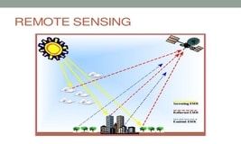
Geographic Information Systems (GIS) and Remote Sensing technologies have revolutionized disaster risk management, providing powerful tools for mapping, monitoring, and mitigating risks associated with natural and human-induced disasters. These technologies enable decision-makers to analyze and visualize data, identify vulnerable areas, and develop strategies to reduce the impact of disasters. The Training Course on GIS and Remote Sensing in Disaster Risk Management is designed to equip professionals with the skills to effectively use these technologies in disaster preparedness, response, and recovery efforts.
This course emphasizes practical applications of GIS and Remote Sensing in disaster risk management. Participants will learn how to use these technologies to create hazard maps, conduct risk assessments, and design early warning systems. Additionally, they will explore the use of satellite imagery and geospatial data to monitor disaster-prone areas and plan post-disaster recovery efforts. The course provides hands-on training using real-world case studies to ensure participants can apply the skills directly to their work.
Course Duration
5 Days
Course Objectives
- Understand the fundamental concepts of GIS and Remote Sensing in disaster risk management.
- Learn to collect, analyze, and interpret geospatial data for disaster preparedness and response.
- Develop skills to create hazard maps and conduct risk assessments.
- Explore the use of satellite imagery in monitoring and managing disaster-prone areas.
- Understand how to design and implement early warning systems using GIS and Remote Sensing.
- Gain knowledge on integrating geospatial data into disaster recovery planning.
- Learn about the role of GIS in emergency response coordination.
- Analyze case studies to understand real-world applications of GIS and Remote Sensing in disaster risk management.
- Master the use of GIS software tools for spatial analysis and disaster management.
- Improve decision-making and resource allocation in disaster risk reduction initiatives.
Organizational Benefits
- Enhanced Risk Assessment: Organizations can assess disaster risks more accurately using geospatial data.
- Improved Preparedness: Equip teams with tools to develop comprehensive disaster preparedness plans.
- Effective Response Planning: Use GIS and Remote Sensing to optimize resource allocation during disasters.
- Accurate Hazard Mapping: Generate detailed hazard maps to identify vulnerable areas.
- Data-Driven Decision-Making: Leverage geospatial data for informed disaster management strategies.
- Streamlined Recovery Efforts: Plan efficient post-disaster recovery activities using spatial analysis.
- Increased Resilience: Strengthen organizational resilience against disasters through advanced technologies.
- Stakeholder Confidence: Demonstrate a proactive approach to disaster risk management, gaining trust from stakeholders.
- Cost Savings: Minimize economic losses by implementing effective disaster risk reduction measures.
- Capacity Building: Build internal expertise in GIS and Remote Sensing for long-term disaster management needs.
Target Participants
- Disaster risk management professionals.
- GIS and Remote Sensing specialists.
- Emergency response coordinators.
- Urban planners and development professionals.
- Environmental scientists and conservationists.
- Government officials in disaster preparedness and response.
- NGO staff working in disaster management.
- Academics and researchers in disaster studies.
- Private sector professionals in infrastructure and risk analysis.
- Students and individuals aspiring to build a career in disaster management.
Course Outline
Module 1: Introduction to GIS and Remote Sensing for Disaster and Climate Applications
Fundamentals of GIS and remote sensing (RS)
Types of spatial data and satellite imagery
Role of geospatial technologies in climate and disaster resilience
Platforms and tools (ArcGIS, QGIS, Google Earth Engine, etc.)
Case Study: Use of GIS in Cyclone Idai emergency response
Module 2: Climate Change Monitoring through Satellite Imagery
Remote sensing indicators of climate change (temperature, vegetation, snow cover)
Monitoring land use/land cover changes (LULC)
Mapping glacial retreat and sea level rise
Time series analysis for climate trends
Case Study: Monitoring deforestation in the Amazon using MODIS and Landsat
Module 3: Hazard Mapping and Risk Assessment using GIS
Understanding hazards: floods, droughts, landslides, storms
Creating hazard zonation maps
Vulnerability and exposure mapping
Risk prioritization using spatial multi-criteria analysis (SMCA)
Case Study: Flood risk mapping of the Nairobi River Basin
Module 4: Remote Sensing for Drought and Flood Monitoring
Satellite-based drought indices (NDVI, VCI, SPI)
Hydrological modeling and flood forecasting
Use of SAR imagery in flood mapping
Real-time monitoring platforms (e.g., NASA, Copernicus)
Case Study: Drought monitoring in the Horn of Africa using CHIRPS
Module 5: Early Warning Systems and Decision Support Tools
Integrating GIS in early warning systems (EWS)
Spatial databases for disaster preparedness
Real-time data visualization dashboards
Decision support systems for emergency planning
Case Study: GIS-enabled EWS in Bangladesh’s flood-prone regions
Module 6: GIS for Climate Resilient Infrastructure and Urban Planning
Spatial planning for resilient cities
Mapping critical infrastructure risk zones
Land suitability analysis under climate stress
Incorporating climate projections into urban planning
Case Study: Climate-resilient city planning in Kigali, Rwanda
Module 7: Community-Based GIS and Participatory Risk Mapping
Participatory GIS (PGIS) tools and techniques
Involving local communities in spatial risk analysis
Mapping indigenous knowledge and coping strategies
Mobile data collection (ODK, KoboToolbox)
Case Study: Community-led hazard mapping in the Philippines
Module 8: Data Integration, Reporting & Climate Action Planning
Combining spatial and non-spatial data for reporting
Generating thematic maps and geospatial reports
Climate vulnerability indices (CVI) using GIS
Supporting NDCs and SDGs through geospatial analysis
Case Study: GIS-supported climate action planning in Kenya's ASAL regions
Training Methodology
- Interactive Lectures: Comprehensive presentations by experts on GIS and Remote Sensing applications.
- Hands-On Exercises: Practical sessions using GIS software tools to analyze real-world disaster scenarios.
- Case Study Analysis: Detailed exploration of successful applications of GIS and Remote Sensing in disaster risk management.
- Group Discussions: Collaborative problem-solving to address disaster management challenges.
- Field Simulations: Real-life exercises to implement disaster response strategies using geospatial data.
- Peer Review Sessions: Exchange of ideas and feedback to improve project proposals and analysis.
By completing this Training Course on GIS and Remote Sensing in Disaster Risk Management, participants will acquire the knowledge and skills to transform disaster risk management strategies, enhancing their ability to save lives and protect communities.
Register as a group from 3 participants for a Discount
Send us an email: info@datastatresearch.org or call +254724527104
Certification
Upon successful completion of this training, participants will be issued with a globally- recognized certificate.
Tailor-Made Course
We also offer tailor-made courses based on your needs.
Key Notes
a. The participant must be conversant with English.
b. Upon completion of training the participant will be issued with an Authorized Training Certificate
c. Course duration is flexible and the contents can be modified to fit any number of days.
d. The course fee includes facilitation training materials, 2 coffee breaks, buffet lunch and A Certificate upon successful completion of Training.
e. One-year post-training support Consultation and Coaching provided after the course.
f. Payment should be done at least a week before commence of the training, to DATASTAT CONSULTANCY LTD account, as indicated in the invoice so as to enable us prepare better for you.