Training Course on Geospatial Data Governance and Policy
Training Course on Geospatial Data Governance and Policy is meticulously designed to equip professionals with the critical knowledge and practical skills needed to establish, implement, and maintain effective geospatial data governance, ensuring data quality, security, and ethical use across organizations.
Course Overview
Training Course on Geospatial Data Governance and Policy
Introduction
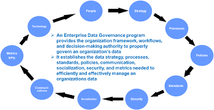
In today's data-driven world, Geospatial Data has become an invaluable asset, powering everything from urban planning and environmental conservation to disaster response and business intelligence. However, the true potential of this rich information can only be unlocked with robust Data Governance and clear Policy Frameworks. Training Course on Geospatial Data Governance and Policy is meticulously designed to equip professionals with the critical knowledge and practical skills needed to establish, implement, and maintain effective geospatial data governance, ensuring data quality, security, and ethical use across organizations. Participants will delve into the complexities of Spatial Data Infrastructure (SDI), Metadata Standards, and Legal Compliance, transforming raw geographic data into trustworthy, actionable insights.
The proliferation of diverse geospatial data sources, coupled with evolving regulatory landscapes and increasing demands for Location Intelligence, necessitates a strategic approach to Geospatial Data Management. This course addresses the urgent need for skilled professionals who can navigate the challenges of data integration, interoperability, and long-term data stewardship. Through a blend of theoretical foundations and hands-on exercises, attendees will learn to develop and enforce Data Policies, implement Quality Assurance protocols, and manage Data Lifecycles, ultimately maximizing the value of their geospatial investments and fostering a culture of Data Integrity within their organizations.
Course Duration
10 days
Course Objectives
- Design and implement comprehensive governance models for spatial data, integrating FAIR data principles (Findable, Accessible, Interoperable, Reusable).
- Develop and apply best practices for Geospatial Data Quality Assurance, including validation, cleansing, and metadata enrichment.
- Understand and adhere to international and national data protection laws (e.g., GDPR, CCPA) as they pertain to Location-Based Services and Privacy by Design.
- Define roles, responsibilities, and accountability for Geospatial Data Stewards throughout the data lifecycle.
- Create clear, actionable policies for data acquisition, storage, sharing, access, and archival.
- Apply ISO 19115/19119 standards for creating discoverable and interoperable geospatial metadata.
- Design and enhance organizational SDIs for efficient data sharing and collaborative environments.
- Implement strategies for safeguarding sensitive geospatial information and mitigating Cybersecurity risks.
- Foster the use of common data models and standards to enhance data exchange and integration.
- Understand governance implications and best practices for managing geospatial data in Cloud GIS environments.
- Empower organizations to use high-quality, governed geospatial data for strategic planning and Predictive Analytics.
- Establish systems for tracking changes, maintaining data history, and ensuring transparency in data transformations.
- Promote understanding and appreciation for data governance principles across all levels of the organization.
Organizational Benefits
- Access to high-quality, reliable geospatial data leads to more informed and strategic decisions.
- Proactive adherence to data privacy regulations and security standards minimizes legal and financial penalties.
- Streamlined data workflows, reduced data duplication, and enhanced data accessibility boost productivity.
- A strong governance framework builds confidence in the accuracy and reliability of geospatial information.
- Better understanding of data assets and their value enables more efficient allocation of resources.
- Standardized data and clear policies promote seamless data sharing and collaboration across departments and with external partners.
- Organizations with mature geospatial data governance can leverage location intelligence for innovation and market differentiation.
- Established governance ensures the long-term usability, accessibility, and value of geospatial data investments.
Target Audience
- GIS Managers and Coordinators.
- Data Scientists and Analysts.
- IT Professionals and Database Administrators.
- Policy Makers and Regulators.
- Urban Planners and Environmental Managers.
- Project Managers.
- Data Stewards and Custodians.
- Researchers and Academicians.
Course Outline
Module 1: Introduction to Geospatial Data Governance
- Defining Geospatial Data Governance: Principles, importance, and scope.
- The Evolving Landscape of Geospatial Data: Trends in big data, IoT, and AI.
- Key Components of a Geospatial Data Governance Framework: People, processes, and technology.
- Challenges in Geospatial Data Management: Data silos, quality issues, and regulatory complexities.
- Case Study: The impact of poor data governance on a municipal smart city initiative, leading to inaccurate public services.
Module 2: Foundational Concepts of Geospatial Data
- Understanding Spatial Data Types: Vector, raster, and point cloud data.
- Coordinate Reference Systems and Projections: Ensuring spatial accuracy and consistency.
- Geospatial Data Formats and Standards: Shapefiles, GeoJSON, KML, GML, and their implications for interoperability.
- Data Acquisition Methods: Remote sensing, GPS, surveying, and crowd-sourcing.
- Case Study: A global humanitarian organization struggled with integrating spatial data from various field teams due to inconsistent CRSs and formats, highlighting the need for standardization.
Module 3: Geospatial Data Lifecycle Management
- Data Planning and Acquisition: Strategic data needs assessment and responsible sourcing.
- Data Processing and Transformation: Cleaning, validating, and enriching raw geospatial data.
- Data Storage and Archiving: Best practices for secure and accessible data repositories.
- Data Dissemination and Use: Controlled access, sharing mechanisms, and licensing.
- Data Retirement and Disposal: Ensuring secure and compliant data deletion.
- Case Study: A national mapping agency implemented a new data lifecycle management plan to improve public access to authoritative geospatial data while ensuring long-term preservation.
Module 4: Metadata Standards and Management
- The Importance of Geospatial Metadata: Discoverability, usability, and data quality.
- Key Metadata Standards: ISO 19115 (Geographic Information — Metadata), ISO 19119 (Geographic Information — Services).
- Creating and Maintaining High-Quality Metadata: Tools and workflows.
- Metadata Catalogs and Geoportals: Facilitating data discovery and access.
- Automated Metadata Generation and Validation.
- Case Study: A scientific research institution improved data discoverability and reuse by enforcing strict ISO-compliant metadata standards across all new spatial datasets.
Module 5: Geospatial Data Quality Assurance
- Defining Data Quality Dimensions: Accuracy, completeness, consistency, timeliness, validity.
- Geospatial Data Validation Techniques: Geometric, topological, and attribute validation.
- Error Detection and Correction: Strategies for identifying and resolving data inaccuracies.
- Data Quality Metrics and Reporting: Measuring and monitoring data quality over time.
- Implementing Data Quality Control Processes: Integrating QC into the data workflow.
- Case Study: A utility company significantly reduced operational errors and costs by implementing a rigorous geospatial data quality assurance program for its infrastructure network data.
Module 6: Legal and Ethical Considerations in Geospatial Data
- Data Privacy Laws (GDPR, CCPA) and Geospatial Data: Anonymization, pseudonymization, and consent.
- Intellectual Property Rights and Licensing: Data ownership, copyright, and usage agreements.
- Data Sharing Agreements and Memoranda of Understanding (MoUs).
- Ethical Use of Location Data: Bias, surveillance, and fairness.
- Data Security and Breach Notification Requirements.
- Case Study: A company faced legal challenges due to improper handling and sharing of consumer location data, highlighting the critical need for legal compliance.
Module 7: Developing Geospatial Data Policies
- Policy Development Frameworks: Principles, scope, and objectives.
- Key Policy Areas: Data access, security, sharing, retention, and acceptable use.
- Stakeholder Engagement in Policy Formulation: Achieving buy-in and compliance.
- Communicating and Enforcing Data Policies: Training and awareness programs.
- Policy Review and Update Mechanisms: Ensuring policies remain relevant.
- Case Study: A national government agency successfully implemented a new open data policy for geospatial information, leading to increased transparency and public engagement.
Module 8: Geospatial Data Security and Risk Management
- Threat Landscape for Geospatial Data: Cyberattacks, data breaches, and insider threats.
- Access Control and Authentication: Implementing granular permissions for spatial data.
- Data Encryption and Anonymization Techniques.
- Incident Response and Disaster Recovery Planning for Geospatial Systems.
- Risk Assessment and Mitigation Strategies for Location-Based Data.
- Case Study: A defense organization prevented a major data breach of sensitive geospatial intelligence by implementing multi-factor authentication and robust network segmentation.
Module 9: Geospatial Data Stewardship and Roles
- Defining Data Stewardship: Responsibilities, skills, and accountability.
- Roles and Responsibilities in a Data Governance Council for Geospatial Data.
- Establishing a Data Governance Operating Model for Spatial Data.
- Training and Empowerment of Data Stewards.
- Performance Measurement for Data Governance Initiatives.
- Case Study: A large corporation established a dedicated team of geospatial data stewards, resulting in significant improvements in data quality and consistency across departments.
Module 10: Spatial Data Infrastructure (SDI) Governance
- Components of a Modern SDI: Data, standards, technology, policies, and people.
- Governing National and Regional SDIs: Inter-agency cooperation and funding models.
- Open Data Initiatives and SDI: Promoting public access to geospatial data.
- Leveraging Cloud Computing for SDI Development.
- Measuring the Success and Impact of SDI Initiatives.
- Case Study: A regional government successfully built a collaborative SDI, enabling seamless data exchange between local authorities and emergency services.
Module 11: Geospatial Data Interoperability and Standardization
- The Importance of Interoperability: Facilitating data exchange and integration.
- Open Geospatial Consortium (OGC) Standards: WMS, WFS, WPS, and their applications.
- Data Harmonization and Transformation for Interoperability.
- Semantic Interoperability and Ontologies in Geospatial Data.
- Challenges and Solutions for Cross-Platform Data Exchange.
- Case Study: A multi-national engineering firm improved project efficiency by adopting OGC standards for sharing CAD and GIS data across different software platforms.
Module 12: Emerging Trends in Geospatial Data Governance
- Big Geospatial Data Governance: Managing massive datasets from IoT, satellites, and sensors.
- Artificial Intelligence (AI) and Machine Learning (ML) in Data Governance.
- Blockchain for Data Provenance and Trust in Geospatial Data.
- Digital Twins and Geospatial Data Governance.
- The Future of Location Intelligence and its Governance Implications.
- Case Study: A logistics company explored using blockchain to verify the authenticity and origin of supply chain geospatial data, enhancing trust and transparency.
Module 13: Implementing and Monitoring Governance Initiatives
- Developing a Geospatial Data Governance Roadmap.
- Tools and Technologies for Data Governance Implementation.
- Key Performance Indicators (KPIs) for Measuring Governance Success.
- Continuous Improvement and Adaptation of Governance Frameworks.
- Auditing and Compliance Checks for Geospatial Data Policies.
- Case Study: A large environmental agency successfully launched its data governance program by piloting it on a critical dataset and demonstrating measurable improvements.
Module 14: Communication and Change Management
- Building a Culture of Data Literacy and Governance Awareness.
- Effective Communication Strategies for Data Policy Rollout.
- Managing Resistance to Change in Data Practices.
- Training and Capacity Building for All Stakeholders.
- Promoting Data Governance Champions within the Organization.
- Case Study: A public health department overcame initial resistance to new data sharing policies through comprehensive training and highlighting the benefits for public service delivery.
Module 15: Capstone Project & Future Outlook
- Group Project: Developing a Mini Geospatial Data Governance Plan for a simulated organization.
- Presentation and Peer Feedback on Governance Plans.
- Review of Global Best Practices and Case Studies.
- Identifying Personal and Organizational Actionable Steps.
- Q&A and Discussion on Future Challenges and Opportunities in Geospatial Data Governance.
- Case Study: Participants analyze a real-world scenario of a city struggling with uncoordinated geospatial data and propose a comprehensive governance strategy.
Training Methodology
Our training employs a highly interactive and practical methodology, combining:
- Expert-led Lectures: Engaging presentations delivering core concepts and theoretical foundations.
- Interactive Discussions: Fostering peer-to-peer learning and knowledge exchange.
- Hands-on Exercises and Workshops: Practical application of tools and techniques for data quality, metadata creation, and policy development.
- Real-world Case Studies: In-depth analysis of successful and challenging geospatial data governance implementations.
- Group Activities and Collaborative Problem-Solving: Encouraging teamwork and diverse perspectives.
- Software Demonstrations: Utilizing industry-standard GIS and data management platforms.
- Q&A Sessions: Addressing specific participant challenges and questions.
- Capstone Project: A culminating activity where participants apply learned concepts to a practical scenario.
Register as a group from 3 participants for a Discount
Send us an email: info@datastatresearch.org or call +254724527104
Certification
Upon successful completion of this training, participants will be issued with a globally- recognized certificate.
Tailor-Made Course
We also offer tailor-made courses based on your needs.
Key Notes
a. The participant must be conversant with English.
b. Upon completion of training the participant will be issued with an Authorized Training Certificate
c. Course duration is flexible and the contents can be modified to fit any number of days.
d. The course fee includes facilitation training materials, 2 coffee breaks, buffet lunch and A Certificate upon successful completion of Training.
e. One-year post-training support Consultation and Coaching provided after the course.
f. Payment should be done at least a week before commence of the training, to DATASTAT CONSULTANCY LTD account, as indicated in the invoice so as to enable us prepare better for you.