Training Course on Geospatial data augmentation for Deep Learning
Training Course on Geospatial data augmentation for Deep Learning offers a comprehensive exploration of advanced geospatial data preprocessing, feature engineering, and augmentation strategies tailored for deep learning applications.
Course Overview
Training Course on Geospatial data augmentation for Deep Learning
Introduction
The proliferation of geospatial data from diverse sources like satellites, drones, and ground sensors has ushered in an era of unprecedented opportunities for understanding our planet. However, leveraging this voluminous and often heterogeneous data for advanced analytical tasks, particularly with deep learning (DL) models, presents significant challenges. A primary hurdle is the inherent scarcity of richly annotated training datasets, which are crucial for the robust performance of DL architectures. Geospatial data augmentation emerges as a critical technique to overcome this limitation, enabling the creation of diverse synthetic training samples from existing data and thereby improving model generalization and robustness. This course delves into the theoretical foundations and practical applications of these cutting-edge techniques.
Training Course on Geospatial data augmentation for Deep Learning offers a comprehensive exploration of advanced geospatial data preprocessing, feature engineering, and augmentation strategies tailored for deep learning applications. Participants will gain hands-on experience with state-of-the-art tools and methodologies for generating synthetic geospatial data, balancing datasets, and enhancing model performance across various GeoAI tasks such as land cover classification, object detection, and change detection. By mastering these techniques, professionals can unlock the full potential of geospatial big data, drive innovation in their respective fields, and contribute to data-driven decision-making in critical sectors like environmental monitoring, urban planning, and disaster management.
Course Duration
10 days
Course Objectives
Upon completion of this course, participants will be able to:
- Understand the fundamental concepts of deep learning and its application to geospatial data.
- Identify the challenges of data scarcity and imbalance in geospatial deep learning.
- Master various geospatial data augmentation techniques
- Apply advanced preprocessing and feature engineering methods for diverse geospatial datasets.
- Utilize open-source libraries and frameworks (e.g., TensorFlow, PyTorch, GDAL, Geopandas) for geospatial data manipulation.
- Implement augmentation pipelines to improve model generalization and reduce overfitting.
- Evaluate the impact of different augmentation strategies on deep learning model performance.
- Develop robust deep learning models for geospatial image classification and segmentation.
- Perform object detection and change detection using augmented geospatial imagery.
- Address class imbalance issues effectively through targeted data augmentation.
- Leverage cloud-based geospatial platforms for scalable data augmentation workflows.
- Design and execute end-to-end GeoAI projects incorporating data augmentation.
- Stay updated with trending research and best practices in geospatial data augmentation for deep learning.
Organizational Benefits
- Develop more accurate and robust deep learning models by overcoming data limitations, leading to better insights and predictions.
- Minimize the need for extensive, costly, and time-consuming manual data collection and annotation efforts by effectively leveraging existing datasets.
- Enable data-driven decisions in critical areas like urban planning, disaster response, environmental conservation, and resource management.
- Foster innovation and gain a competitive edge by deploying cutting-edge GeoAI solutions.
- Improve efficiency in various operations by automating complex geospatial analysis tasks.
- Empower teams with specialized skills in advanced geospatial AI, enhancing internal capabilities and productivity.
- Enhance predictive capabilities for natural disasters, infrastructure failures, and other geospatial risks.
Target Audience
- Geospatial Analysts and Scientists
- Data Scientists and Machine Learning Engineers data.
- Remote Sensing Specialists
- GIS Professionals
- Urban Planners and Environmental Researchers
- Academics and Students.
- Software Developers
- Professionals in Agriculture, Forestry, and Disaster Management.
Course Outline
Module 1: Introduction to Deep Learning for Geospatial Data
- Understanding the convergence of GIS, Remote Sensing, and AI
- Overview of Deep Learning architectures.
- Challenges and opportunities in Geospatial Deep Learning
- Introduction to popular Deep Learning frameworks.
- Ethical considerations and biases in GeoAI
- Case Study: Analyzing historical satellite imagery trends using traditional GIS vs. deep learning approaches for identifying urban sprawl and its environmental impact, highlighting the efficiency gains of DL.
Module 2: Geospatial Data Fundamentals and Preprocessing
- Types of geospatial data
- Geospatial data formats and standards
- Core preprocessing techniques:
- Handling missing data and outliers
- Feature engineering for spatial contexts
- Case Study: Preprocessing Sentinel-2 imagery for land cover classification by applying atmospheric correction, masking clouds, and normalizing reflectance values across different bands.
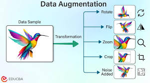
Module 3: Introduction to Data Augmentation
- What is data augmentation
- Why data augmentation for geospatial data
- Categories of data augmentation techniques.
- Common pitfalls and best practices.
- Measuring the impact of augmentation.
- Case Study: Augmenting a small dataset of drone images for defect detection on solar panels by applying basic rotations, flips, and brightness adjustments to increase training sample diversity.
Module 4: Geometric Data Augmentation Techniques
- Rotations, flips, and translations.
- Scaling and cropping.
- Elastic deformations.
- Random erasing and cutout
- Implementation with image processing libraries
- Case Study: Augmenting satellite imagery for road network extraction by applying random rotations and shifts to train a model robust to different road orientations and positions.
Module 5: Photometric Data Augmentation Techniques
- Brightness and contrast adjustments.
- Color jittering and saturation changes
- Adding noise (Gaussian, Salt & Pepper)
- Blurring and sharpening.
- Combining geometric and photometric augmentations
- Case Study: Improving a deep learning model's ability to classify crop types under different weather conditions by augmenting drone imagery with varying brightness, contrast, and color shifts.
Module 6: Advanced Augmentation: Generative Models (GANs)
- Introduction to Generative Adversarial Networks (GANs).
- GANs for synthetic geospatial image generation
- Conditional GANs (cGANs) for specific scenarios:
- Evaluating GAN-generated synthetic data
- Challenges and limitations of GANs in geospatial contexts.
- Case Study: Generating synthetic urban scenes using GANs to augment datasets for training models to detect specific building types, overcoming privacy concerns or data acquisition limitations.
Module 7: Advanced Augmentation: Variational Autoencoders (VAEs) and Diffusion Models
- Understanding Variational Autoencoders (VAEs).
- VAEs for geospatial data reconstruction and generation.
- Introduction to Diffusion Models.
- Applying Diffusion Models for geospatial data augmentation.
- Comparison of GANs, VAEs, and Diffusion Models for augmentation
- Case Study: Using VAEs to generate augmented climate model outputs, creating more diverse scenarios for training predictive models for extreme weather events.
Module 8: Augmentation for Specific Geospatial Data Types
- Hyperspectral and Multispectral Data Augmentation
- Lidar Point Cloud Augmentation.
- Time-Series Geospatial Data Augmentation
- Vector Data Augmentation
- Multimodal Geospatial Data Augmentation
- Case Study: Augmenting a lidar point cloud dataset to improve a deep learning model's ability to classify individual trees in a forest, simulating variations in scanning angles and tree structures.
Module 9: Data Augmentation for Class Imbalance
- Understanding class imbalance in geospatial datasets
- Strategies for addressing imbalance with augmentation
- SMOTE and its variants for spatial data.
- Adversarial training for robust classifiers.
- Evaluation metrics for imbalanced datasets.
- Case Study: Balancing a dataset for landslide detection where landslide instances are rare, by synthetically generating additional landslide examples using augmentation techniques to improve model sensitivity
Module 10: Augmentation Pipelines and Frameworks
- Building custom data augmentation pipelines.
- Using built-in augmentation features in TensorFlow/Keras and PyTorch.
- Automated data augmentation
- Efficient data loading and augmentation for large datasets.
- Deployment considerations for augmented models.
- Case Study: Setting up an automated augmentation pipeline for training a CNN to classify land cover on a continental scale, streamlining the data preparation process for massive datasets.
Module 11: Geospatial Object Detection with Augmented Data
- Introduction to object detection in geospatial imagery
- Common object detection architectures.
- Augmentation strategies specific to object detection
- Training and evaluating object detection models
- Applications of object detection in geospatial contexts.
- Case Study: Detecting illegal mining sites from satellite imagery, using augmented data to improve the model's ability to identify small, irregularly shaped objects under various environmental conditions.
Module 12: Geospatial Semantic Segmentation with Augmented Data
- Understanding semantic segmentation
- Architectures for semantic segmentation
- Augmentation techniques for segmentation masks.
- Training and evaluating semantic segmentation models
- Applications in land cover mapping and change detection.
- Case Study: Mapping urban green spaces with high precision using augmented aerial imagery, allowing for better identification of vegetation types and distribution at a pixel level.
Module 13: Geospatial Change Detection and Time Series Augmentation
- Principles of change detection.
- Deep learning approaches for change detection
- Augmenting multi-temporal geospatial datasets
- Handling temporal variations and seasonal changes
- Applications in disaster assessment, deforestation, and urban growth monitoring.
- Case Study: Monitoring deforestation in the Amazon rainforest using bi-temporal satellite images, employing time-series augmentation to account for seasonal variations and improve the detection of illegal logging activities.
Module 14: Cloud-Based Geospatial Deep Learning and Augmentation
- Leveraging cloud platforms for scalable GeoAI
- Distributed training of deep learning models
- Cloud-based data augmentation services:
- Managing computational resources for GeoAI workflows:
- Best practices for deploying GeoAI models in the cloud
- Case Study: Training a large-scale deep learning model for global land cover mapping using Google Earth Engine's computational power and its integrated data augmentation capabilities.
Module 15: Advanced Topics and Future Trends
- Explainable AI (XAI) in Geospatial Deep Learning: Interpreting model decisions.
- Federated Learning for distributed geospatial data.
- Self-supervised and semi-supervised learning for geospatial data
- Novel augmentation techniques and research directions
- Emerging applications of GeoAI
- Case Study: Exploring the use of self-supervised learning with augmented unlabeled satellite imagery to pre-train a model for flood extent mapping, reducing the need for extensive manual labeling.
Training Methodology
This training course will adopt a highly interactive and hands-on approach, blending theoretical concepts with practical application. The methodology will include:
- Lectures and Presentations: Clear and concise explanations of core concepts, algorithms, and methodologies, supported by visually engaging slides and real-world examples.
- Live Coding Demonstrations: Step-by-step demonstrations of implementing data augmentation techniques and deep learning models using Python with libraries like TensorFlow, PyTorch, OpenCV, GDAL, and Geopandas.
- Hands-on Labs and Exercises: Practical sessions where participants apply learned concepts to real geospatial datasets, developing and testing their own augmentation pipelines and deep learning models.
- Case Studies and Group Discussions: Analysis of real-world GeoAI problems and solutions, fostering collaborative problem-solving and critical thinking.
- Q&A Sessions: Dedicated time for participants to ask questions and clarify doubts with instructors.
- Project-Based Learning: Participants will work on a final project, applying the full spectrum of data augmentation and deep learning techniques to a geospatial problem of their choice.
- Access to Cloud-Based Platforms: Guided exercises on platforms like Google Earth Engine, AWS, or Azure for scalable data processing and model training.
Register as a group from 3 participants for a Discount
Send us an email: info@datastatresearch.org or call +254724527104
Certification
Upon successful completion of this training, participants will be issued with a globally- recognized certificate.
Tailor-Made Course
We also offer tailor-made courses based on your needs.
Key Notes
a. The participant must be conversant with English.
b. Upon completion of training the participant will be issued with an Authorized Training Certificate
c. Course duration is flexible and the contents can be modified to fit any number of days.
d. The course fee includes facilitation training materials, 2 coffee breaks, buffet lunch and A Certificate upon successful completion of Training.
e. One-year post-training support Consultation and Coaching provided after the course.
f. Payment should be done at least a week before commence of the training, to DATASTAT CONSULTANCY LTD account, as indicated in the invoice so as to enable us prepare better for you.