Training Course on Geographic Information Systems (GIS) for Telecommunications Network Planning
Training Course on Geographic Information Systems (GIS) for Telecommunications Network Planning is meticulously designed to provide a comprehensive understanding of how geospatial data, network modeling, and spatial analysis can address complex challenges in the telecommunications sector.
Course Overview
Training Course on Geographic Information Systems (GIS) for Telecommunications Network Planning
Introduction
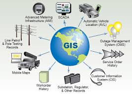
Geographic Information Systems (GIS) have emerged as indispensable tools for modern telecommunications, transforming how network planning, deployment, and management are executed. This training course delves into the synergistic relationship between GIS technology and telecom network infrastructure, equipping professionals with the essential skills to leverage spatial data analytics for optimized network performance, enhanced customer satisfaction, and significant cost savings. By integrating location intelligence, telecom operators can move beyond traditional planning methods, embracing a data-driven approach for 5G rollout, fiber optic deployment, and smart city infrastructure.
Training Course on Geographic Information Systems (GIS) for Telecommunications Network Planning is meticulously designed to provide a comprehensive understanding of how geospatial data, network modeling, and spatial analysis can address complex challenges in the telecommunications sector. Participants will gain practical expertise in utilizing leading GIS software to visualize, analyze, and manage extensive telecom assets, from cell towers and fiber cables to customer locations and service coverage areas. The course emphasizes real-world applications and hands-on exercises, ensuring that participants can immediately apply their newfound knowledge to improve operational efficiency, streamline network expansion, and make informed strategic decisions within their organizations.
Course Duration
10 days
Course Objectives
Upon completion of this training, participants will be able to:
- Grasp the core concepts of GIS, including spatial data types, coordinate systems, and map projections relevant to telecommunications.
- Learn techniques for collecting, managing, and integrating diverse geospatial data sources for telecom planning.
- Apply advanced GIS analytical tools for network optimization, site selection, and demand forecasting.
- Utilize GIS for FTTH network design, fiber route planning, and splice management.
- Employ GIS for cell tower placement, signal propagation analysis, and coverage optimization.
- Implement GIS for comprehensive asset management, inventory tracking, and maintenance scheduling.
- Leverage GIS for real-time network monitoring, outage management, and service quality assessment.
- Understand the integration of GIS with Operational Support Systems (OSS) and Business Support Systems (BSS).
- Explore the application of GIS in creating and enhancing location-based services for customers.
- Use GIS to identify and mitigate risks, enhancing network resilience and disaster recovery planning.
- Understand how GIS aids in meeting telecom regulatory requirements and reporting.
- Gain proficiency in using popular open-source GIS software alongside commercial solutions.
- Produce high-quality thematic maps, dashboards, and reports for effective decision-making and communication.
Organizational Benefits
- Achieve optimal network designs that reduce infrastructure costs and improve service delivery.
- Streamline the planning and deployment phases for new technologies like 5G and Fiber to the Home (FTTH), leading to faster market entry.
- Automate asset management, fault detection, and maintenance scheduling, reducing operational overheads.
- Make data-driven decisions on resource deployment, minimizing idle assets and maximizing return on investment.
- Improve service quality, reduce outage durations, and enable precise location-based services, leading to higher customer satisfaction and retention.
- Identify new market opportunities, analyze demographic trends, and prioritize expansion areas effectively.
- Proactively identify and mitigate network vulnerabilities, ensuring business continuity during disruptions.
- Empower management with comprehensive geospatial insights for strategic planning and competitive advantage.
- Minimize costly errors in planning and deployment, reduce fieldwork, and optimize resource utilization.
Target Audience
- Network Engineers
- GIS Analysts/Specialists.
- Project Managers.
- Telecom Planners.
- IT Professionals in Telecom.
- Field Technicians
- Data Scientists/Analysts.
- Consultants.
Course Outline
Module 1: Introduction to GIS and Telecommunications
- Overview of GIS
- Role of GIS in Telecom.
- Key GIS Software & Platforms
- Geospatial Data in Telecom
- Benefits of Location Intelligence
- Case Study: "Mapping Existing Infrastructure for Network Modernization": An established telecom company uses GIS to map all existing copper and fiber infrastructure, identifying areas for upgrade and redundancy, leading to a 15% reduction in initial survey costs.
Module 2: Geospatial Data Acquisition and Management
- Data Sources.
- Data Collection Techniques
- Data Formats & Standards.
- Data Cleaning and Validation.
- Metadata Management.
- Case Study: "Rapid Data Collection for 5G Small Cell Deployment": A new telecom entrant uses drones and mobile GIS apps to rapidly collect high-resolution data on street furniture and building facades, accelerating small cell site identification by 30%.
Module 3: Coordinate Systems and Projections for Telecom
- Geographic vs. Projected Coordinate Systems.
- Common Projections in Telecom.
- Transformations and Reprojection.
- Impact of Projection on Analysis.
- Best Practices for Georeferencing.
- Case Study: "Ensuring Positional Accuracy for Fiber Splicing": A telecom operator implements strict georeferencing protocols for all fiber splice locations, reducing field errors during maintenance by 20% due to precise spatial alignment.
Module 4: Spatial Analysis Fundamentals for Network Planning
- Basic Geoprocessing Operations.
- Spatial Queries.
- Proximity Analysis.
- Overlay Analysis
- Network Dataset Creation
- Case Study: "Optimizing Cable Trenching Routes": A company uses buffering and intersection analysis to plan cable trenching routes, avoiding obstacles like rivers and high-traffic areas, resulting in a 10% saving on civil works.
Module 5: Fiber Optic Network Planning with GIS
- FTTH Network Architecture.
- Fiber Route Optimization
- Splice Point and Cabinet Placement
- Bill of Materials (BOM) Generation.
- As-Built Documentation.
- Case Study: "Accelerated FTTH Rollout in a Suburban Area": A regional ISP uses GIS to design and optimize its FTTH network, reducing design time by 40% and deployment time by 25% due to precise planning and material estimation.
Module 6: Wireless Network Planning with GIS
- Cell Tower Site Selection.
- Signal Propagation Modeling.
- Interference Analysis.
- Coverage Gap Analysis
- Small Cell and DAS Planning.
- Case Study: "Enhancing 5G Coverage in a City District": A mobile operator uses GIS-based propagation models and 3D city models to optimize 5G small cell placement, achieving 95% targeted coverage with fewer sites
Module 7: Telecom Asset Management and Inventory
- GIS as an Asset Register
- Attribute Management
- Integration with Enterprise Systems.
- Maintenance Scheduling & Tracking.
- Lifecycle Management.
- Case Study: "Centralized Asset Management for a National Telecom Provider": A large telecom company implements an enterprise GIS to manage millions of assets across the country, leading to a 10% reduction in maintenance costs and improved asset utilization.
Module 8: Network Operations and Maintenance with GIS
- Real-time Network Monitoring.
- Outage Management.
- Field Force Automation.
- Damage Assessment & Repair.
- Performance Analytics.
- Case Study: "Rapid Response to Cable Faults": A telecom operator uses GIS to pinpoint underground cable faults, dispatching repair crews efficiently and reducing average repair time by 30%.
Module 9: Customer Experience and Location-Based Services (LBS)
- Customer Location Mapping.
- Service Availability Checks.
- Churn Prediction.
- Targeted Marketing.
- Developing LBS Applications
- Case Study: "Improving Customer Service through Location Awareness": An internet service provider uses GIS to quickly identify affected customers during an outage, providing proactive updates and improving customer satisfaction scores by 15%.
Module 10: Regulatory Compliance and Reporting
- Mapping Service Obligations.
- Infrastructure Sharing Compliance.
- Environmental Impact Assessment
- Emergency Services Integration.
- Auditing and Reporting.
- Case Study: "Streamlining Regulatory Reporting for Universal Service Obligations": A telecom provider uses GIS to demonstrate its compliance with universal service obligations, automating report generation and reducing manual effort by 50%.
Module 11: Integration of GIS with Telecom OSS/BSS
- Understanding OSS and BSS.
- Data Exchange Architectures.
- Benefits of Integration.
- Common Integration Challenges
- Future Trends: Cloud-based integration and real-time data synchronization.
- Case Study: "Seamless Workflow from Sales to Service Delivery": A telecom company integrates its CRM (BSS) with its GIS-based network inventory (OSS), enabling sales teams to instantly check service availability and streamline new customer connections.
Module 12: Advanced GIS for Strategic Planning
- Market Analysis & Segmentation.
- Competitor Analysis.
- Demographic Analysis.
- Capacity Planning.
- ROI Analysis.
- Case Study: "Strategic Broadband Expansion in Rural Areas": A government-backed initiative uses GIS to identify unserved and underserved rural communities, prioritizing broadband infrastructure investment based on population density and socio-economic factors.
Module 13: Introduction to Web GIS and Mobile GIS
- Concepts of Web GIS.
- Mobile GIS Applications.
- Cloud-based GIS Platforms.
- Data Sharing and Collaboration.
- Security Considerations.
- Case Study: "Empowering Field Technicians with Real-time Data": A telecom firm deploys a mobile GIS application for its field technicians, allowing them to access network maps, update asset information, and report issues in real-time, improving response times.
Module 14: Data Visualization and Cartography for Telecom
- Principles of Effective Map Design.
- Thematic Mapping
- Creating Dashboards.
- 3D Visualization.
- Reporting and Presentation.
- Case Study: "Visualizing Network Health for Executive Decisions": A telecom executive team uses a GIS-powered dashboard to monitor real-time network health, identify performance trends, and quickly assess the impact of network upgrades.
Module 15: Future Trends in GIS for Telecommunications
- AI and Machine Learning in GIS
- Big Data Analytics
- Digital Twins.
- Edge Computing and IoT Integration.
- Augmented Reality (AR) in Field Operations
- Case Study: "Predictive Maintenance with AI-Powered GIS": A leading telecom company leverages AI with GIS data to predict potential network failures based on historical patterns and environmental factors, implementing proactive maintenance and reducing unplanned outages by 20%.
Training Methodology
- Instructor-Led Presentations: Clear and concise explanations of core GIS and telecom concepts.
- Hands-on Software Exercises: Extensive practical sessions using industry-standard GIS software (e.g., ArcGIS Pro, QGIS) with real-world telecom datasets.
- Case Studies and Practical Scenarios: In-depth analysis and discussion of real-world challenges and solutions in telecom network planning using GIS.
- Group Discussions and Collaborative Projects: Fostering peer-to-peer learning and problem-solving.
- Demonstrations: Live demonstrations of complex GIS functionalities and workflows.
- Q&A Sessions: Opportunities for participants to clarify doubts and explore specific interests.
- Practical Assignments: Take-home assignments to reinforce learning and application of skills.
Register as a group from 3 participants for a Discount
Send us an email: info@datastatresearch.org or call +254724527104
Certification
Upon successful completion of this training, participants will be issued with a globally- recognized certificate.
Tailor-Made Course
We also offer tailor-made courses based on your needs.
Key Notes
a. The participant must be conversant with English.
b. Upon completion of training the participant will be issued with an Authorized Training Certificate
c. Course duration is flexible and the contents can be modified to fit any number of days.
d. The course fee includes facilitation training materials, 2 coffee breaks, buffet lunch and A Certificate upon successful completion of Training.
e. One-year post-training support Consultation and Coaching provided after the course.
f. Payment should be done at least a week before commence of the training, to DATASTAT CONSULTANCY LTD account, as indicated in the invoice so as to enable us prepare better for you.