Training Course on Enterprise GIS Architecture Design and Implementation
Training Course on Enterprise GIS Architecture Design and Implementation is meticulously designed to empower GIS professionals, IT architects, and spatial data managers with the cutting-edge knowledge and practical skills required to design, implement, and manage robust Enterprise GIS architectures.
Course Overview
Training Course on Enterprise GIS Architecture Design and Implementation
Introduction
Training Course on Enterprise GIS Architecture Design and Implementation is meticulously designed to empower GIS professionals, IT architects, and spatial data managers with the cutting-edge knowledge and practical skills required to design, implement, and manage robust Enterprise GIS architectures. In today's data-driven world, a well-planned and scalable geospatial infrastructure is paramount for organizations to unlock the full potential of their spatial data, optimize operations, and gain a competitive advantage through location intelligence. Participants will delve into best practices, industry standards, and modern technologies to build efficient, secure, and resilient GIS systems that seamlessly integrate with existing enterprise IT landscapes.
The course emphasizes a holistic approach to Enterprise GIS deployment, moving beyond mere software usage to encompass strategic planning, system integration, data governance, and performance optimization. Through a blend of theoretical instruction, hands-on exercises, and real-world case studies, attendees will master the intricacies of cloud GIS, distributed geodatabases, web services, and GIS security. This program is crucial for organizations aiming to maximize their return on investment (ROI) in geospatial technology, streamline decision-making processes, and foster a truly data-centric culture that leverages the power of "where."
Course Duration
5 days
Course Objectives
- Strategize and plan an optimal Enterprise GIS architecture aligned with organizational goals and future growth, incorporating digital transformation initiatives.
- Design scalable and resilient GIS infrastructure, including cloud-native GIS deployments (AWS, Azure, Google Cloud) and hybrid cloud solutions.
- Implement robust geodatabase management strategies, focusing on big data, real-time data streams, and spatial data warehousing.
- Master the principles of GIS web service publication and consumption, leveraging REST APIs, OGC standards, and microservices architecture.
- Develop effective GIS data governance frameworks, ensuring data quality, security, and compliance with regulations.
- Understand and apply GIS security best practices, including identity and access management (IAM), network security, and data encryption.
- Optimize GIS system performance through efficient server configurations, caching mechanisms, and spatial indexing.
- Design and implement mobile GIS and field data collection solutions for enhanced operational efficiency.
- Integrate Enterprise GIS with existing business intelligence (BI), ERP, and other organizational systems using API integration and ETL processes.
- Explore advanced GIS analytics capabilities, including spatial machine learning, AI-powered geospatial analysis, and predictive modeling.
- Troubleshoot common Enterprise GIS implementation challenges and develop effective mitigation strategies.
- Evaluate and select appropriate GIS software platforms (Esri ArcGIS Enterprise, QGIS Server, GeoServer) and open-source GIS technologies for specific architectural needs.
- Develop a comprehensive GIS deployment roadmap and establish key performance indicators (KPIs) for ongoing monitoring and improvement.
Organizational Benefits
- Provides a unified, accurate, and real-time view of spatial data for informed strategic and operational decisions.
- Streamlines workflows, automates tasks, and reduces redundancies across departments.
- Cost Reduction: Optimizes infrastructure, minimizes data duplication, and enables efficient resource allocation.
- Fosters a collaborative environment by centralizing spatial data and making it accessible across the enterprise.
- Ensures the GIS infrastructure can grow with organizational needs and adapt to technological advancements.
- Implements robust security measures and governance frameworks to protect sensitive spatial information.
- Enables location-based services and insights to improve responsiveness and engagement with stakeholders.
- Facilitates the adoption of emerging geospatial technologies like AI and real-time analytics, driving innovation.
Target Audience
- GIS Managers and Coordinators
- GIS Architects and Developers
- IT Architects and System Administrators.
- Database Administrators (DBAs
- Data Scientists and Analysts
- Project Managers
- Consultants
- Anyone with foundational GIS knowledge
Course Modules
Module 1: Foundations of Enterprise GIS Architecture
- Defining Enterprise GIS: Understanding the components, benefits, and challenges of enterprise-wide geospatial systems.
- Architectural Paradigms: Exploring centralized, decentralized, and distributed GIS architectures.
- Key Architectural Components: Databases, servers, web services, clients, and their interconnections.
- Strategic Planning for GIS: Aligning GIS strategy with organizational business objectives and digital transformation goals.
- Case Study: City of Boston's Enterprise GIS Modernization: How Boston transitioned from departmental silos to a unified enterprise GIS, improving public services and data accessibility.
Module 2: Geospatial Data Management and Geodatabase Design
- Enterprise Geodatabases: Deep dive into data models, topologies, and versioning for multi-user environments.
- Big Data and Spatial Databases: Managing large volumes of spatial data using distributed databases (e.g., PostgreSQL/PostGIS, Oracle Spatial, SQL Server Spatial).
- Data Quality and Integrity: Implementing validation rules, domains, and sub-types for robust data.
- Data Governance and Metadata Management: Establishing policies for data ownership, access, and documentation.
- Case Study: National Land Registry's Spatial Data Harmonization: How a national agency standardized and integrated diverse land parcel data into a single enterprise geodatabase for enhanced property management.
Module 3: Server-Side GIS: ArcGIS Enterprise & Open Source Alternatives
- ArcGIS Enterprise Components: Understanding Portal for ArcGIS, ArcGIS Server, Data Store, and ArcGIS Web Adaptor.
- Deployment Patterns: Single-machine, multi-machine, and highly available deployments for ArcGIS Enterprise.
- Open Source GIS Servers: Introduction to GeoServer and MapServer for cost-effective spatial data serving.
- Performance Tuning and Scalability: Optimizing server configurations, caching, and load balancing.
- Case Study: Utility Company's Scalable Network Management System: A large utility deployed a highly available ArcGIS Enterprise infrastructure to manage and analyze its vast network assets in real-time.
Module 4: Web GIS Development and Web Services
- Principles of Web GIS: Architecture of web mapping applications and client-server interactions.
- GIS Web Services: Publishing map services, feature services, geoprocessing services, and image services.
- OGC Standards: Implementing WMS, WFS, WCS, and WPS for interoperability.
- Client-Side Development Frameworks: Introduction to ArcGIS API for JavaScript, Leaflet, and OpenLayers.
- Case Study: Environmental Agency's Public Data Portal: An environmental agency developed a public-facing web GIS portal using open-source tools and OGC services to share environmental monitoring data.
Module 5: Cloud GIS Architectures and Deployment
- Cloud Computing Fundamentals for GIS: IaaS, PaaS, SaaS models and their relevance to GIS.
- Cloud Providers for GIS: Leveraging AWS, Azure, and Google Cloud for hosting GIS infrastructure.
- Designing Cloud-Native GIS: Containerization (Docker, Kubernetes) and serverless architectures for GIS.
- Cost Optimization in the Cloud: Strategies for managing cloud expenses for GIS deployments.
- Case Study: Startup's Global Logistics Optimization Platform: A logistics startup built its entire spatial analysis platform on AWS, leveraging cloud scalability and cost-efficiency for global operations.
Module 6: GIS Security and Authentication
- GIS Security Best Practices: Principles of layered security, least privilege, and threat modeling.
- Authentication and Authorization: Implementing enterprise logins, SAML, OAuth2, and role-based access control (RBAC).
- Network Security for GIS: Firewalls, VPNs, and secure communication protocols (HTTPS).
- Data Encryption and Privacy: Protecting sensitive spatial data at rest and in transit.
- Case Study: Government Agency's Secure Spatial Data Sharing: A government agency implemented stringent security protocols and multi-factor authentication for its sensitive geospatial intelligence platform.
Module 7: GIS Integration and Advanced Analytics
- Integrating GIS with Enterprise Systems: Connecting GIS with ERP, CRM, and BI systems using APIs and ETL.
- Real-time GIS and IoT Integration: Processing and visualizing streaming spatial data from sensors and IoT devices.
- Spatial Machine Learning: Applying machine learning algorithms to spatial datasets for pattern recognition and prediction.
- Geospatial AI Applications: Exploring AI in image analysis, feature extraction, and automated mapping.
- Case Study: Smart City Initiative's Integrated Urban Dashboard: A smart city project integrated GIS with IoT sensor data, traffic management systems, and public safety platforms to create a real-time urban operational dashboard.
Module 8: Project Management and Future Trends in Enterprise GIS
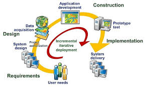
- GIS Project Lifecycle: Planning, design, implementation, testing, and deployment of Enterprise GIS.
- Change Management for GIS Adoption: Strategies for successful organizational adoption of new GIS systems.
- Monitoring and Maintenance: Tools and techniques for ensuring the health and performance of Enterprise GIS.
- Emerging Trends: Digital twins, metaverse, geospatial big data analytics, edge computing, and blockchain in GIS.
- Case Study: Large Retailer's Location Analytics Platform Evolution: A major retail chain continuously evolved its Enterprise GIS, integrating new technologies like AI and real-time footfall analysis to optimize store locations and marketing campaigns.
Training Methodology
- Instructor-Led Presentations
- Interactive Discussions.
- Hands-on Labs and Exercises
- Real-world Case Studies.
- Group Activities and Workshops
- Q&A Sessions.
- Post-Training Resources.
Register as a group from 3 participants for a Discount
Send us an email: info@datastatresearch.org or call +254724527104
Certification
Upon successful completion of this training, participants will be issued with a globally- recognized certificate.
Tailor-Made Course
We also offer tailor-made courses based on your needs.
Key Notes
a. The participant must be conversant with English.
b. Upon completion of training the participant will be issued with an Authorized Training Certificate
c. Course duration is flexible and the contents can be modified to fit any number of days.
d. The course fee includes facilitation training materials, 2 coffee breaks, buffet lunch and A Certificate upon successful completion of Training.
e. One-year post-training support Consultation and Coaching provided after the course.
f. Payment should be done at least a week before commence of the training, to DATASTAT CONSULTANCY LTD account, as indicated in the invoice so as to enable us prepare better for you.