Training Course on Digital Twin Technology and Geospatial Integration
Training Course on Digital Twin Technology and Geospatial Integration delves into the convergence of real-time digital replicas with the power of geospatial intelligence, offering unprecedented insights into complex physical assets and systems.
Course Overview
Training Course on Digital Twin Technology and Geospatial Integration
Introduction
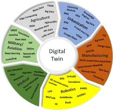
In an era defined by digital transformation and the urgent need for data-driven decision-making, Digital Twin Technology stands out as a revolutionary paradigm. Training Course on Digital Twin Technology and Geospatial Integration delves into the convergence of real-time digital replicas with the power of geospatial intelligence, offering unprecedented insights into complex physical assets and systems. Participants will explore how IoT sensors, AI/ML, and advanced GIS capabilities create a living, breathing virtual environment that mirrors reality, enabling predictive analytics, optimized operations, and sustainable infrastructure management across diverse sectors.
The integration of Digital Twin Technology with Geospatial Information Systems (GIS) unlocks a powerful synergy, providing a holistic and spatially aware understanding of our built and natural environments. This training is meticulously designed to equip professionals with the cutting-edge skills to build, manage, and leverage geospatial digital twins for enhanced urban planning, smart city development, precision agriculture, asset lifecycle management, and environmental monitoring. Through practical case studies and hands-on exercises, attendees will master the methodologies to fuse vast datasets, visualize complex interactions, and simulate future scenarios, driving significant ROI and fostering innovation in their respective fields.
Course Duration
10 days
Course Objectives
- Comprehend the core concepts, architecture, and lifecycle of digital twin models.
- Skillfully merge diverse geospatial datasets (LiDAR, satellite imagery, BIM, CAD) into digital twin environments.
- Design and deploy IoT sensor networks for continuous real-time data acquisition for digital twins.
- Apply Artificial Intelligence and Machine Learning algorithms for predictive maintenance, anomaly detection, and scenario simulation within digital twins.
- Create immersive 3D city models and 4D temporal visualizations for enhanced spatial understanding.
- Utilize digital twins for comprehensive asset performance monitoring, preventive maintenance, and operational efficiency.
- Apply geospatial digital twins for urban development, traffic management, and infrastructure resilience.
- Explore and work with leading cloud platforms and Digital Twin as a Service (DTaaS) solutions.
- Address challenges in data integration, standardization, and cybersecurity for robust digital twin implementations.
- Conduct advanced spatial analysis and run "what-if" simulations to inform strategic decision-making.
- Employ digital twins for environmental monitoring, resource optimization, and climate change adaptation.
- Develop compelling business cases and assess the return on investment for digital twin initiatives.
- Identify and apply digital twin and geospatial integration across manufacturing, construction, utilities, and public safety sectors.
Organizational Benefits
- Streamline processes, reduce downtime, and optimize resource allocation through real-time monitoring and predictive insights.
- Minimize maintenance costs, prevent costly failures, and improve asset lifespan by proactively addressing issues identified through digital twins.
- Gain a holistic, data-driven understanding of complex systems, enabling more informed and strategic choices.
- Simulate various scenarios and identify potential vulnerabilities, leading to more robust infrastructure and disaster preparedness.
- Foster a culture of technological adoption and unlock new possibilities for product development, service delivery, and urban planning.
- Support environmental stewardship and resource optimization by monitoring and simulating ecological impacts.
- Position the organization at the forefront of technological advancement, attracting talent and clients who value innovation.
Target Audience
- GIS Professionals & Specialists
- Urban Planners & City Managers
- Engineers
- IT & Data Scientists
- Project Managers & Consultants
- Asset Owners & Operators.
- Environmental Scientists & Resource Managers.
- Researchers & Academics.
Course Outline
Module 1: Introduction to Digital Twin Technology
- Defining Digital Twins: Virtual replicas, real-time synchronization, and bidirectional data flow.
- Evolution of Digital Twins: From CAD/BIM to dynamic, connected models.
- Key Components: Physical asset, virtual model, data, connectivity, analytics.
- Benefits across Industries: Manufacturing, AEC, Smart Cities, Utilities.
- Case Study: Siemens' use of digital twins for optimizing turbine performance.
Module 2: Fundamentals of Geospatial Information Systems (GIS)
- GIS Concepts: Spatial data types, coordinate systems, projections, data models.
- Geospatial Data Sources: Satellite imagery, LiDAR, aerial photography, open data.
- GIS Software Overview: ArcGIS, QGIS, open-source alternatives.
- Basic Spatial Analysis: Buffering, overlay, network analysis.
- Case Study: Using GIS to map and analyze urban infrastructure for development.
Module 3: The Synergy: Digital Twin & Geospatial Integration
- Why Integrate? Adding spatial context, enhancing visualization, improving decision-making.
- Architectural Frameworks: Connecting disparate data sources (BIM, IoT, GIS).
- Data Fusion Techniques: Sensor data fusion, point cloud integration.
- Challenges and Opportunities: Interoperability, data volume, real-time processing.
- Case Study: Singapore's Smart Nation initiative leveraging integrated geospatial digital twins for urban management.
Module 4: Reality Capture Technologies for Digital Twins
- Lidar Scanning: Principles, applications, and data processing for 3D models.
- Photogrammetry: Creating 3D models from 2D images.
- UAV/Drone-based Data Acquisition: High-resolution aerial mapping.
- Sensor Technologies: GNSS, IMUs, environmental sensors.
- Case Study: Capturing existing building conditions for a digital twin using LiDAR and drones in a commercial renovation project.
Module 5: Building Information Modeling (BIM) for Digital Twins
- BIM Overview: Parametric modeling, lifecycle management, collaboration.
- BIM to Digital Twin Workflow: Leveraging BIM data for virtual asset creation.
- Data Exchange Standards: IFC, CityGML, and their role in interoperability.
- Enriching BIM with Geospatial Context: Georeferencing models, integrating site data.
- Case Study: Using BIM models to create a digital twin of a new hospital building, enhancing facility management post-construction.
Module 6: IoT Sensor Integration and Data Streaming
- IoT Architecture: Devices, connectivity, platforms, analytics.
- Types of Sensors: Environmental, structural, occupancy, energy.
- Data Protocols & Communication: MQTT, CoAP, LoRaWAN.
- Real-time Data Pipelines: Ingesting and processing sensor data for the digital twin.
- Case Study: Monitoring bridge structural health using IoT sensors and streaming data to a digital twin for real-time risk assessment.
Module 7: Cloud Platforms for Digital Twins
- Cloud Computing Fundamentals: IaaS, PaaS, SaaS in the context of digital twins.
- Leading Cloud Platforms: AWS IoT TwinMaker, Azure Digital Twins, Google Cloud.
- Scalability and Storage: Managing vast amounts of digital twin data.
- Security and Access Control: Protecting sensitive digital twin information.
- Case Study: Deploying a smart city digital twin on an Azure platform to manage public services and infrastructure.
Module 8: Data Management and Governance for Digital Twins
- Data Quality & Cleansing: Ensuring accuracy and consistency of input data.
- Data Interoperability: Addressing format differences and integration challenges.
- Metadata Management: Documenting and understanding digital twin data.
- Data Security & Privacy: Compliance with regulations (e.g., GDPR) in digital twin environments.
- Case Study: Establishing data governance protocols for a national digital twin program to ensure data integrity and security.
Module 9: 3D/4D Visualization of Geospatial Digital Twins
- Immersive Visualization Techniques: VR, AR, and Mixed Reality for digital twins.
- Web-based 3D Portals: Sharing and interacting with digital twins in browsers.
- Dynamic Scene Generation: Visualizing real-time data updates within the 3D model.
- Temporal Visualization (4D): Showing changes over time (construction progress, environmental shifts).
- Case Study: Developing a virtual reality application to visualize a proposed urban development project, allowing stakeholders to experience it before construction.
Module 10: Advanced Analytics and AI/ML for Digital Twins
- Predictive Analytics: Forecasting asset failures, energy consumption, and traffic patterns.
- Anomaly Detection: Identifying unusual behavior in real-time data streams.
- Machine Learning Models: Training models for predictive insights and operational optimization.
- Simulation and Scenario Planning: Running "what-if" analyses to test different strategies.
- Case Study: Using AI to predict maintenance needs for wind turbines based on digital twin data, reducing unplanned downtime.
Module 11: Digital Twins for Smart Cities and Urban Planning
- Smart City Applications: Traffic management, public safety, utility optimization.
- Urban Planning & Development: Simulating new infrastructure, assessing environmental impact.
- Resilience and Disaster Management: Modeling flood risks, earthquake impacts, emergency response.
- Citizen Engagement: Using digital twins to communicate urban plans to the public.
- Case Study: Developing a digital twin of a city district to optimize public transport routes and manage waste collection.
Module 12: Digital Twins in Infrastructure and Utilities
- Infrastructure Lifecycle Management: Roads, bridges, railways, pipelines.
- Utility Networks: Electricity grids, water supply, telecommunications.
- Predictive Maintenance & Asset Health Monitoring: Ensuring continuous operation.
- Network Optimization: Improving efficiency and reliability of utility services.
- Case Study: Implementing a digital twin for a water treatment plant to monitor processes, predict equipment failures, and optimize energy consumption.
Module 13: Digital Twins in Manufacturing and Industrial IoT (IIoT)
- Factory Digital Twins: Optimizing production lines, supply chain management.
- Predictive Quality Control: Using digital twins to ensure product quality.
- Remote Monitoring & Operations: Managing industrial assets from a distance.
- Worker Safety and Training: Simulating hazardous environments for training.
- Case Study: Creating a digital twin of an automotive assembly line to identify bottlenecks and improve production efficiency.
Module 14: Economic Value and ROI of Digital Twin Implementation
- Quantifying Benefits: Cost savings, revenue generation, risk reduction.
- Business Case Development: Building compelling arguments for investment.
- Key Performance Indicators (KPIs): Measuring the success of digital twin projects.
- Implementation Strategies: Phased approaches, pilot projects.
- Case Study: Analyzing the ROI of a digital twin implementation for a large-scale construction project, demonstrating significant savings in rework and schedule overruns.
Module 15: Future Trends and Emerging Technologies
- Blockchain for Digital Twins: Enhancing data security and traceability.
- Edge Computing & Digital Twins: Processing data closer to the source for faster insights.
- Digital Twins as a Service (DTaaS): Democratizing access to digital twin capabilities.
- Quantum Computing & Digital Twins: Future potential for complex simulations.
- Ethical Considerations: Data privacy, bias in AI models.
- Case Study: Exploring the potential of integrating blockchain with a supply chain digital twin to enhance transparency and security.
Training Methodology
This course employs a dynamic and interactive training methodology designed for maximum engagement and practical skill development.
- Instructor-led Sessions: Expert-led presentations covering theoretical concepts and industry best practices.
- Hands-on Workshops: Practical exercises using industry-standard software (e.g., ArcGIS Pro, Unity/Unreal Engine for visualization, Python for data processing, cloud platforms like AWS/Azure).
- Case Study Analysis: In-depth examination of real-world digital twin and geospatial integration projects across various sectors.
- Group Discussions & Problem Solving: Collaborative activities to foster critical thinking and knowledge sharing.
- Demonstrations: Live demonstrations of digital twin platform capabilities and geospatial analysis tools.
- Guest Speakers: Industry professionals sharing their experiences and insights.
- Project-Based Learning: Participants will work on a mini-project throughout the course, applying learned concepts to a practical scenario.
- Q&A Sessions: Dedicated time for addressing participant queries and clarifying concepts.
Register as a group from 3 participants for a Discount
Send us an email: info@datastatresearch.org or call +254724527104
Certification
Upon successful completion of this training, participants will be issued with a globally- recognized certificate.
Tailor-Made Course
We also offer tailor-made courses based on your needs.
Key Notes
a. The participant must be conversant with English.
b. Upon completion of training the participant will be issued with an Authorized Training Certificate
c. Course duration is flexible and the contents can be modified to fit any number of days.
d. The course fee includes facilitation training materials, 2 coffee breaks, buffet lunch and A Certificate upon successful completion of Training.
e. One-year post-training support Consultation and Coaching provided after the course.
f. Payment should be done at least a week before commence of the training, to DATASTAT CONSULTANCY LTD account, as indicated in the invoice so as to enable us prepare better for you.