Training Course on Convolutional Neural Networks (CNNs) for Geospatial Imagery
Training Course on Convolutional Neural Networks (CNNs) for Geospatial Imagery is designed to equip professionals with the practical skills and theoretical understanding necessary to leverage CNNs for advanced remote sensing image analysis.
Course Overview
Training Course on Convolutional Neural Networks (CNNs) for Geospatial Imagery
Introduction
The proliferation of high-resolution satellite imagery and drone data has transformed various sectors, from urban planning and agriculture to environmental monitoring and disaster management. Extracting meaningful insights from this vast amount of geospatial data requires sophisticated analytical tools. This training course delves into Convolutional Neural Networks (CNNs), the powerhouse of deep learning for image recognition, specifically tailored for geospatial applications. Participants will gain hands-on experience in building, training, and deploying CNN models to unlock the full potential of satellite and aerial imagery, addressing real-world challenges with cutting-edge AI and machine learning techniques.
Training Course on Convolutional Neural Networks (CNNs) for Geospatial Imagery is designed to equip professionals with the practical skills and theoretical understanding necessary to leverage CNNs for advanced remote sensing image analysis. From foundational concepts of image processing and neural networks to advanced architectures like U-Net and ResNet, the course emphasizes practical implementation using industry-standard libraries such as TensorFlow and PyTorch. By the end of this training, participants will be proficient in tasks such as land cover classification, object detection, change detection, and semantic segmentation of geospatial imagery, driving innovation and efficiency in their respective fields.
Course Duration
10 days
Course Objectives
Upon completion of this training course, participants will be able to:
- Grasp the core concepts of neural networks, backpropagation, and optimization algorithms essential for CNNs.
- Comprehend and differentiate between various CNN architectures, including LeNet, AlexNet, VGGNet, ResNet, and U-Net.
- Effectively prepare and augment satellite and aerial imagery for CNN training, including normalization and data augmentation techniques.
- Develop and deploy CNN models for land cover classification and scene recognition in geospatial imagery.
- Apply advanced CNN models for object detection of features like buildings, roads, and vehicles in remote sensing data.
- Utilize CNNs for pixel-level classification (semantic segmentation) of geospatial images for detailed mapping.
- Leverage pre-trained CNN models and transfer learning techniques to accelerate model development and improve performance on limited datasets.
- Critically assess the performance of CNN models using relevant metrics like accuracy, precision, recall, F1-score, and IoU (Intersection over Union).
- Proficiently use Python with libraries like TensorFlow, Keras, and PyTorch for building and training CNNs.
- Understand and mitigate common challenges in geospatial deep learning, such as data imbalance and cloud interference.
- Implement CNN-based solutions for change detection analysis over time in satellite imagery.
- Understand how CNN outputs can be integrated into existing Geographic Information Systems (GIS) for further spatial analysis.
- Discover emerging applications of CNNs in hyperspectral imagery analysis, Lidar data processing, and spatiotemporal analysis.
Organizational Benefits
- Automate geospatial data analysis, reducing manual effort and accelerating decision-making in tasks like land use mapping and environmental monitoring.
- Achieve higher accuracy in image classification, object detection, and segmentation, leading to more reliable insights for various applications.
- Optimize resource allocation by identifying patterns and changes more efficiently, minimizing the need for extensive field surveys.
- Develop predictive models for trend forecasting, anomaly detection, and optimizing operations in areas like urban planning and disaster response.
- Stay at the forefront of geospatial intelligence by leveraging cutting-edge AI and machine learning technologies.
- Empower teams with the skills to extract actionable intelligence from complex imagery, fostering data-driven strategies.
- Enable the processing and analysis of vast big geospatial data volumes, supporting large-scale projects and regional monitoring.
Target Audience
- Geospatial Analysts and Scientists.
- Data Scientists and Machine Learning Engineers.
- Urban Planners and Developers
- Environmental Scientists and Conservationists
- Agricultural Technologists
- Disaster Response and Humanitarian Aid Professionals
- Researchers and Academics
- Remote Sensing Specialists
Course Outline
Module 1: Introduction to Geospatial Imagery and Deep Learning
- Overview of the geospatial data landscape: sources (satellite, aerial, drone), types (RGB, multispectral, hyperspectral), and applications.
- Introduction to Artificial Intelligence (AI), Machine Learning (ML), and Deep Learning (DL).
- The evolution of neural networks and the emergence of Convolutional Neural Networks (CNNs).
- Why CNNs are exceptionally well-suited for image recognition and pattern extraction in visual data.
- Setting up the development environment: Python, TensorFlow/Keras, PyTorch, and geospatial libraries.
- Case Study: Examining the role of high-resolution satellite imagery in mapping urban sprawl and its environmental impact.
Module 2: Fundamentals of Neural Networks
- Core components of a neural network: neurons, layers (input, hidden, output), weights, and biases.
- Activation functions (ReLU, Sigmoid, Tanh) and their role in introducing non-linearity.
- The concept of forward propagation and backpropagation for learning.
- Loss functions (e.g., cross-entropy) and optimizers (e.g., Gradient Descent, Adam).
- Understanding overfitting and underfitting and initial mitigation strategies.
- Case Study: Simulating a simple neural network to classify basic land cover types (e.g., water vs. land) from simplified pixel values.
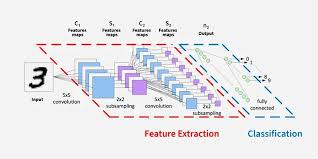
Module 3: Introduction to Convolutional Neural Networks
- Convolutional layers: filters (kernels), strides, padding, and feature maps.
- Pooling layers: Max Pooling, Average Pooling, and their role in dimensionality reduction.
- The hierarchical nature of CNNs for learning complex features.
- Advantages of CNNs over traditional image processing techniques for spatial data.
- Parameter sharing and sparse connectivity in CNNs.
- Case Study: Analyzing how convolutional filters detect edges and textures in a satellite image, forming the basis for object recognition.
Module 4: Data Preprocessing for Geospatial Imagery
- Reading and handling various geospatial image formats (e.g., GeoTIFF, JPEG2000).
- Image resizing, normalization, and standardization techniques.
- Data augmentation: rotation, flipping, cropping, brightness adjustments to enhance model robustness.
- Handling multispectral and hyperspectral data cubes.
- Strategies for dealing with missing data and cloud cover in satellite imagery.
- Case Study: Preprocessing a Sentinel-2 image dataset for a land cover classification task, including atmospheric correction and band stacking.
Module 5: Image Classification with CNNs
- Building classification models for scene recognition and land use/land cover (LULC) mapping.
- Designing and implementing a basic CNN for image classification from scratch.
- Training a CNN: epochs, batch size, learning rate.
- Model evaluation metrics: accuracy, precision, recall, F1-score.
- Interpreting confusion matrices for classification results.
- Case Study: Classifying different agricultural crop types using high-resolution drone imagery to assist in precision farming.
Module 6: Advanced CNN Architectures for Classification
- Exploring popular architectures: LeNet-5, AlexNet, VGGNet.
- Deeper networks and the vanishing gradient problem.
- Introduction to ResNet (Residual Networks) and Inception Networks.
- Understanding the benefits of these advanced architectures for complex geospatial datasets.
- Implementing pre-trained models for transfer learning.
- Case Study: Applying a pre-trained ResNet model to classify urban areas versus natural landscapes from a large dataset of aerial photographs.
Module 7: Object Detection with CNNs
- Introduction to object detection: bounding boxes and class labels.
- Two-stage detectors: R-CNN, Fast R-CNN, Faster R-CNN.
- One-stage detectors: YOLO (You Only Look Once), SSD (Single Shot MultiBox Detector).
- Anchor boxes and Non-Maximum Suppression (NMS).
- Evaluating object detection models: Mean Average Precision (mAP).
- Case Study: Detecting illegal mining sites or informal settlements from satellite imagery using a YOLO-based model for rapid assessment.
Module 8: Semantic Segmentation with CNNs
- Understanding pixel-level classification and its importance in geospatial mapping.
- Fully Convolutional Networks (FCNs).
- The U-Net architecture for medical imaging and its applicability to geospatial data.
- Loss functions for segmentation: Dice Coefficient, Jaccard Index (IoU).
- Post-processing segmentation masks for improved quality.
- Case Study: Generating precise building footprints or road networks from high-resolution aerial imagery using a U-Net model.
Module 9: Change Detection using CNNs
- Concepts of change detection in remote sensing: pixel-based, object-based, and deep learning approaches.
- Architectures for change detection (e.g., Siamese networks, U-Net variants for multi-temporal data).
- Pre-change and post-change image analysis.
- Quantifying and visualizing changes (e.g., deforestation, urban expansion).
- Challenges in change detection (illumination changes, misregistration).
- Case Study: Identifying areas of deforestation in the Amazon rainforest by analyzing multi-temporal satellite images with a CNN-based change detection model.
Module 10: Transfer Learning and Fine-tuning
- The power of transfer learning when labeled data is scarce.
- Strategies for fine-tuning pre-trained models on new geospatial datasets.
- Feature extraction vs. fine-tuning the entire network.
- Choosing the right pre-trained model for your task.
- Domain adaptation for geospatial data.
- Case Study: Adapting a CNN pre-trained on ImageNet to classify specific types of geological formations from limited geological imagery.
Module 11: Interpretable AI and Explainable CNNs in Geospatial
- The "black box" problem in deep learning.
- Techniques for interpreting CNN decisions: Grad-CAM, LIME, SHAP.
- Understanding feature importance and activations in CNN layers.
- Building trust and transparency in AI-driven geospatial solutions.
- Ethical considerations in deploying AI in sensitive geospatial applications.
- Case Study: Interpreting why a CNN misclassified a specific land cover type, using explainability tools to identify problematic features or biases in the training data.
Module 12: Deployment and Productionizing CNN Models
- Saving and loading trained CNN models.
- Model optimization for inference speed and resource efficiency.
- Deployment strategies: local deployment, cloud platforms (AWS Sagemaker, Google AI Platform).
- Building simple web APIs for model inference.
- Monitoring and maintaining models in production.
- Case Study: Deploying a trained CNN model to automatically detect infrastructure damage from drone imagery immediately after a natural disaster, providing real-time data for response teams.
Module 13: Advanced Topics: Hyperspectral and Lidar Data
- Introduction to hyperspectral imagery: spectral signatures and data cubes.
- Adapting CNNs for hyperspectral image classification and unmixing.
- Lidar data processing: point clouds, Digital Elevation Models (DEMs).
- Integrating CNNs with Lidar data for 3D object recognition and terrain analysis.
- Fusion of different sensor data using multi-modal CNNs.
- Case Study: Classifying tree species using airborne hyperspectral imagery and a 3D CNN model, enabling more precise forest inventory.
Module 14: Geospatial Time Series and Spatiotemporal CNNs
- Analyzing time-series geospatial data for dynamic processes.
- Introduction to Recurrent Neural Networks (RNNs) and Long Short-Term Memory (LSTM) for sequential data.
- Combining CNNs with RNNs for spatiotemporal analysis.
- Predicting future trends and anomalies based on historical imagery.
- Applications in climate modeling and environmental forecasting.
- Case Study: Forecasting urban growth patterns over the next decade using multi-year satellite imagery and a spatiotemporal CNN, informing city planning initiatives.
Module 15: Ethics, Bias, and Future Trends in Geospatial AI
- Ethical considerations in geospatial AI: privacy, bias in data and models, fair use.
- Addressing bias in training data and its impact on model performance.
- Emerging trends: Generative Adversarial Networks (GANs) for data augmentation, Self-Supervised Learning, Foundation Models for Earth Observation.
- The future of geospatial intelligence and the role of quantum computing.
- Responsible AI development and deployment in a geospatial context.
- Case Study: Discussing a scenario where a CNN model for identifying vulnerable populations shows bias due to incomplete or skewed training data, and proposing mitigation strategies.
Training Methodology
This training course employs a blended learning methodology that combines theoretical instruction with extensive hands-on practical application, ensuring a deep understanding and skill development.
- Instructor-Led Sessions: Interactive lectures and discussions to introduce core concepts, theories, and best practices.