Training Course on Containerization for Web GIS Deployments
Training Course on Containerization for Web GIS Deployments provides essential knowledge and practical skills for modernizing and optimizing Web GIS infrastructure.
Course Overview
Training Course on Containerization for Web GIS Deployments
Introduction
Training Course on Containerization for Web GIS Deployments provides essential knowledge and practical skills for modernizing and optimizing Web GIS infrastructure. Participants will delve into the power of Docker for packaging GIS applications and their dependencies into portable, isolated containers, and then master Kubernetes for orchestrating, scaling, and managing these containerized deployments at enterprise scale. The course addresses critical challenges in traditional Web GIS setups, such as environment inconsistencies, complex dependencies, and scalability limitations, by leveraging cutting-edge cloud-native technologies.
The program emphasizes a hands-on, practical approach to deploying robust and highly available Web GIS solutions. Through real-world case studies and interactive exercises, learners will gain proficiency in building reproducible environments, implementing CI/CD pipelines for GIS applications, and ensuring high performance and resilience for their geospatial services. This training is designed to empower GIS professionals and developers to embrace agile development practices and unlock the full potential of microservices architecture for their geospatial data management and web mapping initiatives.
Course Duration
5 days
Course Objectives
Upon completion of this course, participants will be able to:
- Understand the core concepts of containerization and orchestration for Web GIS.
- Master Docker fundamentals for building, managing, and versioning GIS application images.
- Create optimized Dockerfiles for various geospatial software stacks (e.g., GeoServer, PostGIS, QGIS Server).
- Implement multi-stage Docker builds for efficient and secure Web GIS deployments.
- Comprehend Kubernetes architecture including Pods, Deployments, Services, and Namespaces.
- Deploy and manage containerized Web GIS applications using Kubernetes.
- Scale Web GIS services dynamically with Kubernetes auto-scaling capabilities.
- Configure persistent storage solutions for geospatial data within Kubernetes clusters.
- Implement network policies and ingress controllers for secure Web GIS access.
- Monitor and troubleshoot containerized Web GIS deployments in a Kubernetes environment.
- Integrate CI/CD pipelines for automated Web GIS application delivery.
- Apply best practices for security and performance optimization in containerized GIS.
- Design resilient and highly available Web GIS architectures using Docker and Kubernetes.
Organizational Benefits
- Streamline the deployment of Web GIS applications, reducing time-to-market for new features and services.
- Dynamically scale GIS services to meet fluctuating demand, ensuring optimal performance under heavy workloads.
- Automate deployment, management, and scaling tasks, reducing manual effort and operational overhead.
- Design fault-tolerant Web GIS systems that can withstand failures and ensure continuous service availability.
- Optimize resource utilization by running multiple containerized applications on shared infrastructure, lowering hardware and licensing expenses.
- Eliminate "it works on my machine" issues by packaging applications and dependencies into reproducible containers, ensuring consistency across development, testing, and production environments.
- Foster better collaboration between development and operations teams through standardized containerized workflows (DevOps).
- Transition to a cloud-native architecture, leveraging modern IT practices for future-proof GIS deployments.
- Improve application isolation and security through containerization and Kubernetes' robust security features.
- Facilitate quicker recovery from outages by leveraging container orchestration for rapid redeployment.
- Empower teams to experiment with new technologies and features more rapidly due to the isolated and portable nature of containers.
- Deploy Web GIS applications across various cloud providers or on-premises infrastructure with greater flexibility.
Target Audience
This training course is designed for:
- GIS Developers.
- DevOps Engineers.
- System Administrators.
- Solution Architects.
- Geospatial Data Scientists.
- IT Professionals.
- GIS Managers
- Cloud Engineers.
Course Outline
Module 1: Introduction to Containerization & Web GIS Fundamentals
- Overview of Web GIS Architecture.
- Introduction to Containerization
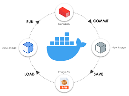
- Docker Ecosystem Basics.
- Web GIS Use Cases for Containerization
- Case Study: Analyzing a traditional, monolithic Web GIS deployment facing scalability issues and inconsistent environments, setting the stage for containerization as a solution.
Module 2: Docker for Geospatial Applications
- Docker Images and Dockerfiles
- Managing Docker Containers
- Volume Management for Geospatial Data.
- Docker Networking for GIS Services
- Case Study: Containerizing a simple Web GIS stack (e.g., a Leaflet map application served by Nginx, with spatial data from a PostGIS database) and demonstrating its portability.
Module 3: Advanced Docker for Web GIS
- Docker Compose for Multi-Container Apps.
- Optimizing Docker Images.
- Container Registries.
- Security Best Practices for Docker.
- Case Study: Migrating an existing Docker Compose-based Web GIS setup to incorporate advanced features like health checks and resource limits.
Module 4: Introduction to Kubernetes Architecture
- Why Kubernetes for Web GIS?
- Kubernetes Core Concepts.
- kubectl CLI.
- Declarative Configuration with YAML
- Case Study: Deconstructing a complex, highly available ArcGIS Enterprise on Kubernetes architecture, highlighting key components.
Module 5: Deploying Web GIS with Kubernetes
- Deployments for Stateless GIS Services
- Services for Network Access
- Persistent Volumes (PV) and Persistent Volume Claims (PVC).
- ConfigMaps and Secrets for GIS Configuration
- Case Study: Deploying a containerized GeoServer instance with a PostGIS database on a Kubernetes cluster, ensuring data persistence and network accessibility.
Module 6: Scaling and Resilience in Kubernetes
- Horizontal Pod Autoscaling (HPA).
- Rolling Updates and Rollbacks.
- Liveness and Readiness Probes.
- Resource Limits and Requests.
- Case Study: Demonstrating how to scale a busy web mapping service during peak load and performing a seamless update to a new version.
Module 7: Advanced Kubernetes for Web GIS
- Ingress Controllers
- StatefulSets for Stateful GIS Applications
- Helm for Package Management
- Namespaces and RBAC.
- Case Study: Implementing a multi-tenant Web GIS platform using namespaces and Helm charts for streamlined deployment of individual GIS projects.
Module 8: Monitoring, Troubleshooting, and CI/CD for Web GIS
- Kubernetes Logging and Monitoring.
- Troubleshooting Common Kubernetes Issues.
- Integrating CI/CD Pipelines
- DevOps Best Practices for Web GIS
- Case Study: Setting up a CI/CD pipeline for a Web GIS application, from code commit to automated deployment to a Kubernetes cluster, demonstrating self-healing capabilities.
Training Methodology
This training course employs a blended learning approach designed for maximum engagement and practical skill acquisition.
- Instructor-Led Sessions: Expert-led lectures and presentations will introduce core concepts, best practices, and theoretical foundations of Docker and Kubernetes in the context of Web GIS.
- Hands-on Labs and Exercises: A significant portion of the course is dedicated to practical, guided exercises. Participants will work with real-world scenarios, building, deploying, and managing containerized Web GIS applications on live environments (e.g., cloud-based Kubernetes clusters or local Docker setups).
- Interactive Demonstrations: The instructor will provide live demonstrations of key concepts and complex configurations, ensuring clarity and understanding.
- Case Studies and Problem-Solving: Real-world case studies related to Web GIS deployment challenges will be analyzed, and participants will work in groups or individually to propose and implement containerization solutions. This fosters critical thinking and problem-solving skills.
- Q&A and Discussion: Ample time will be allocated for questions, discussions, and troubleshooting common issues encountered during the labs.
- Reference Materials: Participants will receive comprehensive course materials, including slides, lab guides, code repositories, and links to relevant documentation for continued learning.
- Peer Learning: Encouraging participants to share their experiences and learn from each other's challenges and successes.
- Assessments (Optional): Short quizzes or practical challenges at the end of modules to reinforce learning and assess comprehension.
Register as a group from 3 participants for a Discount
Send us an email: info@datastatresearch.org or call +254724527104
Certification
Upon successful completion of this training, participants will be issued with a globally- recognized certificate.
Tailor-Made Course
We also offer tailor-made courses based on your needs.
Key Notes
a. The participant must be conversant with English.
b. Upon completion of training the participant will be issued with an Authorized Training Certificate
c. Course duration is flexible and the contents can be modified to fit any number of days.
d. The course fee includes facilitation training materials, 2 coffee breaks, buffet lunch and A Certificate upon successful completion of Training.
e. One-year post-training support Consultation and Coaching provided after the course.
f. Payment should be done at least a week before commence of the training, to DATASTAT CONSULTANCY LTD account, as indicated in the invoice so as to enable us prepare better for you.