Training Course on Building Information Modeling and GIS Integration
Training Course on Building Information Modeling and GIS Integration equips AEC professionals with the essential skills to seamlessly merge these transformative technologies, driving enhanced project lifecycle management, sustainable urban development, and data-driven decision-making.
Course Overview
Training Course on Building Information Modeling and GIS Integration
Introduction
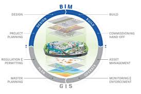
Training Course on Building Information Modeling and GIS Integration equips AEC professionals with the essential skills to seamlessly merge these transformative technologies, driving enhanced project lifecycle management, sustainable urban development, and data-driven decision-making. Explore the synergies between detailed building data and broader geospatial context, fostering interoperability, efficiency, and innovation across design, construction, and operations.
In today's rapidly evolving built environment, the convergence of BIM and GIS is no longer a luxury but a necessity. This course addresses the critical need for professionals to navigate complex projects with a holistic understanding of both the granular building components and their wider environmental context. By mastering GeoBIM workflows, digital twins, and advanced spatial analysis, participants will gain a competitive edge, contributing to resilient infrastructure, smart city initiatives, and optimized asset management in the digital construction era.
Course Duration
10 days
Course Objectives
- Comprehend and implement seamless data exchange and integration workflows between BIM and GIS platforms.
- Understand the application of BIM and GIS in creating and managing digital twins for real-time asset monitoring and predictive maintenance.
- Utilize GIS capabilities to perform advanced spatial analysis on BIM data for optimized site selection, environmental impact assessments, and urban planning.
- Overcome data silos by developing strategies for effective interoperability between diverse BIM and GIS software environments.
- Apply integrated BIM-GIS data for improved planning, design, construction, and operations across the entire project lifecycle.
- Employ BIM-GIS integration for green building certifications, carbon footprint analysis, and sustainable urban design.
- Make informed decisions by integrating granular BIM details with broad geospatial context for superior project outcomes.
- Utilize BIM-GIS for assessing and enhancing the resilience of infrastructure against natural disasters and climate change.
- Apply integrated methodologies for smart city development, intelligent transportation networks, and efficient utility management.
- Create compelling and information-rich 3D/4D visualizations by combining detailed BIM models with geospatial data.
- Understand and implement CDE strategies for collaborative BIM and GIS projects.
- Identify emerging applications of Artificial Intelligence and Machine Learning to enhance BIM-GIS integration.
- Use integrated BIM-GIS models for advanced clash detection and proactive risk mitigation in complex projects.
Organizational Benefits
- Streamlined workflows and reduced data redundancy lead to faster project delivery and cost savings.
- Comprehensive data insights from integrated BIM and GIS facilitate more informed and strategic project decisions.
- Proactive identification of potential issues through spatial analysis and clash detection minimizes project risks and delays.
- Better understanding of asset context and real-time monitoring leads to improved operational efficiency and reduced maintenance costs.
- Facilitates analysis for environmental impact reduction and supports the development of greener infrastructure.
- Fosters interdisciplinary teamwork by providing a common platform for detailed building information and broader geospatial context.
- Equips organizations with the expertise to undertake complex, data-intensive projects and adapt to evolving industry demands.
- Integrated data models minimize discrepancies and errors, leading to higher quality deliverables.
Target Audience
- Architects and Urban Designers
- Civil Engineers and Structural Engineers
- Geospatial Professionals and GIS Analysts
- Construction Managers and Project Managers
- Facility Managers and Asset Owners
- Urban Planners and Regional Developers
- Surveyors and Geomatics Engineers
- Government Officials and Policy Makers in Infrastructure and Urban Development
Course Modules
Module 1: Introduction to BIM and GIS Foundations
- Understanding the core principles and evolution of Building Information Modeling (BIM).
- Exploring the fundamentals of Geographic Information Systems (GIS) and spatial data.
- Identifying the distinct capabilities and complementary nature of BIM and GIS.
- Overview of industry standards and data formats (IFC, Shapefile, GeoJSON).
- Case Study: Analyzing the benefits of a BIM-GIS workflow for initial site assessment of a proposed university campus.
Module 2: Data Interoperability and Exchange Formats
- Challenges and opportunities in BIM-GIS data exchange.
- Methods for converting and transforming BIM data for GIS applications (e.g., IFC to GIS formats).
- Techniques for integrating GIS data into BIM models (georeferencing BIM).
- Utilizing open standards and APIs for seamless data flow.
- Case Study: Examining a real-world project where seamless data exchange between Revit and ArcGIS facilitated efficient land use planning for a new residential complex.
Module 3: Geospatial Contextualization of BIM Models
- Placing BIM models accurately within their real-world geographic context.
- Integrating terrain data, satellite imagery, and aerial photography with BIM.
- Analyzing environmental factors (solar paths, wind patterns) using GIS data in BIM.
- Utilizing georeferenced points and coordinate systems for precise alignment.
- Case Study: The Sydney Opera House used GIS-BIM integration to analyze the site's topography and optimize the building's design and construction, demonstrating effective contextualization.
Module 4: Spatial Analysis for Site Selection and Planning
- Applying GIS spatial analysis tools (buffer, overlay, network analysis) to BIM projects.
- Identifying optimal site locations based on environmental, social, and economic factors.
- Assessing accessibility, connectivity, and proximity for infrastructure planning.
- Performing suitability analysis for various development scenarios.
- Case Study: A municipal project for a new public park utilized GIS to analyze pedestrian flow, proximity to public transport, and surrounding demographics to inform optimal site selection and design.
Module 5: Environmental Impact Assessment with BIM-GIS
- Integrating environmental data (pollution, noise levels, green spaces) with BIM.
- Quantifying the environmental impact of proposed developments.
- Simulating and visualizing environmental changes due to construction.
- Supporting sustainable design decisions through integrated analysis.
- Case Study: The Denver Union Station redevelopment project used GIS-BIM integration to analyze the site's environmental conditions and develop a more sustainable design, including green infrastructure.
Module 6: Infrastructure Planning and Management
- Applying BIM-GIS for linear infrastructure projects (roads, railways, pipelines).
- Managing complex utility networks (water, sewage, electricity) with integrated data.
- Optimizing routing, excavation, and construction logistics.
- Utilizing GIS for asset inventory, maintenance scheduling, and emergency response.
- Case Study: A major urban utility company used BIM-GIS to manage underground infrastructure, enabling accurate mapping, predictive maintenance, and rapid response to outages.
Module 7: Digital Twins and Smart City Applications
- Concept and development of digital twins for built assets and urban environments.
- Integrating real-time sensor data (IoT) with BIM and GIS.
- Applications of digital twins for smart city initiatives, including traffic management and energy optimization.
- Creating immersive and interactive digital twin experiences for stakeholders.
- Case Study: Singapore Sports Hub project used GIS-BIM integration to analyze the site's terrain and optimize the construction process, laying the groundwork for a smart facility management system.
Module 8: BIM-GIS for Disaster Management and Resilience
- Assessing vulnerability and risk in disaster-prone areas using integrated data.
- Developing evacuation plans and emergency response strategies.
- Simulating natural disaster scenarios (floods, earthquakes) and their impact on buildings.
- Utilizing BIM-GIS for post-disaster reconstruction and recovery efforts.
- Case Study: Mexico City used BIM-GIS integration for post-earthquake reconstruction, enabling faster assessment of damaged structures and more effective urban planning for resilience.
Module 9: Advanced Visualization and Communication
- Techniques for creating compelling 3D and 4D visualizations with integrated data.
- Storytelling with maps and models for effective stakeholder communication.
- Utilizing virtual reality (VR) and augmented reality (AR) for immersive experiences.
- Generating high-quality renderings and animations for presentations.
- Case Study: A large-scale urban regeneration project used combined BIM-GIS visualizations to engage community members and secure public approval for ambitious development plans.
Module 10: Common Data Environment (CDE) for Collaboration
- Principles of a Common Data Environment (CDE) in BIM-GIS workflows.
- Setting up and managing CDE platforms for multidisciplinary collaboration.
- Best practices for information sharing, version control, and access management.
- Ensuring data integrity and security in a collaborative environment.
- Case Study: A multinational design and consultancy company implemented a robust CDE for its global BIM-GIS projects, significantly improving inter-team collaboration and data consistency.
Module 11: Legal, Contractual, and Standard Aspects of BIM-GIS
- Understanding legal implications and contractual frameworks for BIM and GIS projects.
- Adhering to international BIM standards (e.g., ISO 19650) in an integrated context.
- Data ownership, intellectual property, and liability in shared data environments.
- Developing protocols for data quality assurance and validation.
- Case Study: Analyzing a contractual dispute resolved by clear data ownership protocols established through a well-defined BIM-GIS implementation plan.
Module 12: Programming and Scripting for BIM-GIS Integration
- Introduction to scripting languages (e.g., Python) for automating BIM-GIS tasks.
- Leveraging APIs and SDKs for custom integrations and data manipulation.
- Developing custom tools and workflows to enhance efficiency.
- Exploring spatial databases for advanced data management.
- Case Study: A construction firm developed a Python script to automate the extraction of quantity takeoff data from BIM models and its integration with GIS for cost analysis, saving significant time.
Module 13: Future Trends: AI, ML, and Blockchain in GeoBIM
- Emerging applications of Artificial Intelligence (AI) and Machine Learning (ML) in BIM-GIS.
- Predictive modeling and data-driven insights through AI/ML.
- The potential of Blockchain technology for secure data management and traceability.
- Exploring the role of big data analytics in integrated BIM-GIS.
- Case Study: Research into using AI-powered algorithms to predict maintenance needs of infrastructure assets by analyzing integrated BIM-GIS data and real-time sensor information.
Module 14: Practical Application Workshop: Integrated Project Simulation
- Hands-on workshop applying learned concepts to a real-world project scenario.
- Participants work in teams to integrate BIM and GIS data for a simulated project.
- Problem-solving exercises covering data conversion, analysis, and visualization.
- Developing a comprehensive integrated project report.
- Case Study: A simulated urban redevelopment project where teams applied all learned BIM-GIS integration techniques, from initial site analysis to final visualization and impact assessment.
Module 15: Career Pathways and Industry Best Practices
- Identifying career opportunities in the evolving field of BIM-GIS integration.
- Networking with industry experts and understanding market demands.
- Review of current industry best practices and successful project implementations.
- Strategies for continuous learning and professional development.
- Case Study: Insights from leading AEC firms on their successful adoption of BIM-GIS integration and the impact on their business growth and project delivery.
Training Methodology
- Instructor-Led Sessions
- Hands-on Software Labs.
- Case Study Analysis
- Project-Based Learning
- Collaborative Exercises.
- Guest Speakers.
- Interactive Demonstrations
- Q&A and Troubleshooting Sessions.
Register as a group from 3 participants for a Discount
Send us an email: [email protected] or call +254724527104
Certification
Upon successful completion of this training, participants will be issued with a globally- recognized certificate.
Tailor-Made Course
We also offer tailor-made courses based on your needs.
Key Notes
a. The participant must be conversant with English.
b. Upon completion of training the participant will be issued with an Authorized Training Certificate
c. Course duration is flexible and the contents can be modified to fit any number of days.
d. The course fee includes facilitation training materials, 2 coffee breaks, buffet lunch and A Certificate upon successful completion of Training.
e. One-year post-training support Consultation and Coaching provided after the course.
f. Payment should be done at least a week before commence of the training, to DATASTAT CONSULTANCY LTD account, as indicated in the invoice so as to enable us prepare better for you.