Training Course on Building Custom AI Models for GIS Workflows
Training Course on Building Custom AI Models for GIS Workflows is meticulously designed to equip GIS professionals, data scientists, and spatial analysts with the cutting-edge skills required to develop and integrate custom Artificial Intelligence (AI) models directly into their Geospatial Information Systems (GIS) workflows.
Course Overview
Training Course on Building Custom AI Models for GIS Workflows
Introduction
Training Course on Building Custom AI Models for GIS Workflows is meticulously designed to equip GIS professionals, data scientists, and spatial analysts with the cutting-edge skills required to develop and integrate custom Artificial Intelligence (AI) models directly into their Geospatial Information Systems (GIS) workflows. In an era dominated by Big Geospatial Data and the imperative for actionable insights, leveraging AI is no longer optional but a critical differentiator. Participants will gain hands-on experience with machine learning, deep learning, and GeoAI frameworks, transforming raw spatial data into predictive analytics and automated processes.
The rapid convergence of AI and GIS is revolutionizing how we understand and interact with our world. This program delves into the practical applications of geospatial artificial intelligence, enabling participants to build robust solutions for complex real-world challenges, from environmental monitoring and urban planning to disaster management and precision agriculture. By mastering the art of custom AI model development, attendees will be at the forefront of spatial data science innovation, driving efficiency, accuracy, and unprecedented analytical capabilities within their organizations.
Course Duration
10 days
Course Objectives
- Comprehend the foundational concepts of Geospatial Artificial Intelligence (GeoAI), Machine Learning (ML), and Deep Learning (DL) in the context of spatial data.
- Develop advanced Python programming skills specifically tailored for geospatial data manipulation, analysis, and AI model integration.
- Acquire expertise in geospatial data preprocessing techniques, including feature engineering, data cleaning, and harmonization for AI readiness.
- Implement and evaluate supervised learning algorithms (e.g., Random Forests, SVMs) for land cover classification, change detection, and image classification in GIS.
- Apply unsupervised learning methods (e.g., K-Means, DBSCAN) to discover spatial patterns, hotspot analysis, and clustering in geospatial datasets.
- Build and deploy Convolutional Neural Networks (CNNs) and other deep learning architectures for satellite imagery analysis, object detection, and segmentation.
- Analyze spatio-temporal datasets using time-series AI models (e.g., LSTMs) for predictive mapping and trend analysis.
- Understand the end-to-end lifecycle of custom AI model development, from data acquisition to model deployment and monitoring.
- Master techniques for evaluating AI model performance using geospatial accuracy metrics and spatial cross-validation.
- Seamlessly integrate custom AI models into popular GIS software platforms (e.g., ArcGIS Pro, QGIS) and geospatial cloud services.
- Design and implement automated geospatial AI pipelines for efficient and reproducible analysis.
- : Explore ethical considerations, bias detection, and responsible AI development in the context of geospatial data.
- Develop capabilities for real-time geospatial data processing and AI-driven decision support systems.
Organizational Benefits
- Enhanced Decision-Making: Leverage predictive analytics and actionable insights derived from AI models for more informed strategic decisions across all departments.
- Increased Operational Efficiency: Automate repetitive GIS tasks, significantly reducing manual effort and accelerating geospatial analysis workflows.
- Cost Reduction: Optimize resource allocation, minimize waste, and improve planning through AI-powered spatial optimization.
- Improved Accuracy and Precision: Achieve higher levels of accuracy in mapping, classification, and change detection, leading to more reliable outputs.
- Competitive Advantage: Position the organization at the forefront of geospatial technology by integrating cutting-edge AI innovation.
- Scalable Geospatial Solutions: Develop scalable AI models capable of processing vast Big Geospatial Data volumes.
- Risk Mitigation: Proactively identify and mitigate risks through AI-driven anomaly detection and hazard mapping.
- Innovation and New Capabilities: Unlock entirely new analytical capabilities and develop innovative geospatial products and services.
Target Audience
- GIS Professionals & Analysts
- Data Scientists
- Remote Sensing Specialists
- Urban Planners & Developers.
- Environmental Scientists & Conservationists.
- Disaster Management & Emergency Response Professionals
- Agriculture & Forestry Experts.
- Researchers & Academics
Course Modules
Module 1: Introduction to Geospatial AI & Machine Learning
- Defining GeoAI: Intersection of AI, ML, DL, and GIS.
- Key applications of AI in diverse geospatial domains.
- Understanding the geospatial data pipeline for AI.
- Overview of essential AI and GIS open-source tools and libraries (e.g., Python, TensorFlow, PyTorch, Scikit-learn, GDAL, GeoPandas).
- Case Study: Overview of how a major tech company uses GeoAI for global land cover mapping.
Module 2: Python for Advanced Geospatial Data Handling
- Setting up the Python environment for GeoAI (Anaconda, virtual environments).
- Advanced GeoPandas for vector data manipulation and spatial operations.
- Working with Rasterio and GDAL for efficient raster data processing.
- Spatial indexing and optimization techniques for large datasets.
- Case Study: Preprocessing satellite imagery for a deforestation detection project in the Amazon, including handling diverse file formats and projections.
Module 3: Geospatial Data Acquisition and Preprocessing for AI
- Sources of geospatial data for AI: Satellite imagery (Sentinel, Landsat), LiDAR, UAV data, OpenStreetMap, sensor networks.
- Techniques for data cleaning, outlier detection, and missing value imputation in spatial data.
- Feature engineering for geospatial attributes (e.g., spectral indices, texture features, contextual information).
- Data normalization, scaling, and transformation for optimal model input.
- Case Study: Preparing a dataset of urban building footprints and demographic data for an AI model predicting urban sprawl.
Module 4: Fundamentals of Supervised Learning for Spatial Data
- Introduction to supervised learning: Classification and Regression for geospatial problems.
- Key algorithms: Random Forest, Support Vector Machines (SVMs), Decision Trees.
- Training, validation, and testing strategies for spatial data.
- Model evaluation metrics for classification (accuracy, precision, recall, F1-score, confusion matrix) and regression (RMSE, R²).
- Case Study: Performing land-use classification in an agricultural region using satellite imagery and ground truth data with Random Forest.
Module 5: Supervised Learning: Advanced Image Classification
- Techniques for creating high-quality training labels for image classification.
- Applying advanced supervised algorithms to multispectral and hyperspectral imagery.
- Strategies for dealing with imbalanced spatial datasets.
- Visualizing classification results and generating thematic maps.
- Case Study: Classifying crop types and health status from drone imagery to inform precision farming strategies.
Module 6: Unsupervised Learning for Spatial Pattern Discovery
- Introduction to unsupervised learning: Clustering and Dimensionality Reduction.
- Algorithms: K-Means, DBSCAN, Hierarchical Clustering for spatial data.
- Identifying natural groupings and anomalies in geospatial datasets.
- Principal Component Analysis (PCA) and t-SNE for visualizing high-dimensional spatial features.
- Case Study: Identifying spatial clusters of environmental pollution sources in an industrial area using sensor data and K-Means clustering.
Module 7: Introduction to Deep Learning for Geospatial Analysis
- Fundamentals of Neural Networks and Deep Learning architectures.
- Convolutional Neural Networks (CNNs) for image-based geospatial tasks.
- Setting up deep learning frameworks: TensorFlow and PyTorch.
- GPU acceleration for efficient deep learning model training.
- Case Study: Building a basic CNN to classify different types of urban infrastructure from aerial imagery.
Module 8: Advanced Deep Learning: Object Detection & Segmentation
- Deep learning models for object detection in satellite and aerial imagery (e.g., YOLO, Faster R-CNN).
- Semantic Segmentation (U-Net, FCN) for pixel-level classification.
- Preparing training data with bounding boxes and segmentation masks.
- Evaluating object detection and segmentation model performance (IoU, mAP).
- Case Study: Automatically detecting buildings and roads from high-resolution satellite imagery for urban mapping and planning.
Module 9: Spatio-Temporal AI: Time-Series Analysis
- Handling time-series geospatial data (e.g., daily satellite observations, sensor logs).
- Recurrent Neural Networks (RNNs) and Long Short-Term Memory (LSTM) networks for sequential spatial data.
- Predicting future spatial patterns and trends.
- Change detection over time using spatio-temporal AI models.
- Case Study: Monitoring deforestation rates and predicting future forest loss using time-series Landsat data and LSTM models.
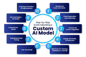
Module 10: Custom AI Model Development and Training
- Designing custom AI model architectures for specific GIS problems.
- Hyperparameter tuning and optimization techniques (Grid Search, Random Search).
- Transfer learning and fine-tuning pre-trained models for geospatial tasks.
- Strategies for handling limited labeled data.
- Case Study: Developing a custom CNN model to identify specific types of agricultural stress from drone imagery, tailored to local crop variations.
Module 11: AI Model Evaluation, Validation, and Interpretation
- Advanced spatial cross-validation techniques (e.g., blocked cross-validation).
- Addressing spatial autocorrelation and its impact on model performance.
- Interpreting AI model outputs and understanding feature importance in geospatial contexts.
- Bias detection and mitigation strategies in geospatial AI models.
- Case Study: Conducting a thorough validation of a land-use change detection model, including analyzing areas of high uncertainty and potential biases.
Module 12: Integrating AI Models with GIS Platforms
- Exporting trained AI models for deployment.
- Integrating custom AI models with ArcGIS Pro using ArcPy and deep learning tools.
- Leveraging QGIS for integrating and visualizing AI model outputs via Python plugins.
- Connecting AI models to geospatial cloud platforms (e.g., Google Earth Engine, AWS SageMaker for geospatial).
- Case Study: Developing an ArcGIS Pro tool that uses a trained AI model to automatically classify features in newly acquired satellite imagery.
Module 13: Automating Geospatial AI Workflows
- Building end-to-end automated pipelines for recurring geospatial AI tasks.
- Scripting workflows for data ingestion, model inference, and result generation.
- Version control and reproducibility for AI-driven GIS projects.
- Best practices for scaling AI workflows for large datasets.
- Case Study: Automating a flood extent mapping process using real-time satellite data and a pre-trained AI segmentation model, triggered by heavy rainfall events.
Module 14: Deploying and Monitoring Geospatial AI Models
- Strategies for deploying AI models in production environments (local, cloud, edge).
- Creating web services and APIs for accessing AI-powered geospatial insights.
- Model monitoring and maintenance: detecting model drift and ensuring performance.
- User interfaces for interacting with AI-driven GIS applications.
- Case Study: Deploying an object detection model to identify illegal mining sites from daily satellite imagery and setting up an alert system for new detections.
Module 15: Future Trends and Ethical Considerations in GeoAI
- Emerging trends: Explainable AI (XAI) in GIS, federated learning, generative AI for geospatial data.
- The role of AI in digital twins and smart cities.
- Ethical implications of AI in geospatial applications: privacy, bias, accountability.
- Responsible AI development guidelines for the geospatial sector.
- Case Study: Discussion on the ethical challenges and potential biases in using AI for urban surveillance or predictive policing based on spatial data.
Training Methodology.
- Instructor-Led Sessions.
- Practical Lab Exercises
- Case Study Analysis.
- Group Discussions and Collaborative Projects.
- Live Coding Demonstrations
- Q&A Sessions.
- Pre- and Post-Course Assessments
- Resource Sharing.
Register as a group from 3 participants for a Discount
Send us an email: info@datastatresearch.org or call +254724527104
Certification
Upon successful completion of this training, participants will be issued with a globally- recognized certificate.
Tailor-Made Course
We also offer tailor-made courses based on your needs.
Key Notes
a. The participant must be conversant with English.
b. Upon completion of training the participant will be issued with an Authorized Training Certificate
c. Course duration is flexible and the contents can be modified to fit any number of days.
d. The course fee includes facilitation training materials, 2 coffee breaks, buffet lunch and A Certificate upon successful completion of Training.
e. One-year post-training support Consultation and Coaching provided after the course.
f. Payment should be done at least a week before commence of the training, to DATASTAT CONSULTANCY LTD account, as indicated in the invoice so as to enable us prepare better for you.