Training Course on Areal Interpolation and Spatial Aggregation Techniques
Training Course on Areal Interpolation and Spatial Aggregation Techniques delves into the theoretical foundations and practical applications of these crucial geospatial data science methodologies.
Course Overview
Training Course on Areal Interpolation and Spatial Aggregation Techniques
Introduction
In today's data-driven world, Geographic Information Systems (GIS) and spatial analysis are indispensable tools for understanding complex phenomena. Often, vital data is collected and reported across diverse geospatial boundaries, posing significant challenges for integrated analysis and informed decision-making. Areal interpolation and spatial aggregation techniques provide powerful solutions by enabling the seamless transformation and integration of data from disparate geographic units, unlocking deeper insights and facilitating more robust spatial modeling.
Training Course on Areal Interpolation and Spatial Aggregation Techniques delves into the theoretical foundations and practical applications of these crucial geospatial data science methodologies. Participants will gain proficiency in a range of techniques, from classical areal weighting to advanced dasymetric mapping and geostatistical methods, ensuring they can effectively address real-world challenges like population disaggregation, environmental modeling, and urban planning. Through hands-on exercises and case studies, attendees will master the art of transforming raw spatial data into actionable intelligence, bridging the gap between varied datasets and empowering precise location intelligence for diverse applications.
Course Duration
10 days
Course Objectives
Upon completion of this training, participants will be able to:
- Comprehend the fundamental principles of areal interpolation and spatial aggregation in geospatial analysis.
- Differentiate between various interpolation methods, including areal weighting, pycnophylactic interpolation, and dasymetric mapping.
- Apply advanced geostatistical techniques for spatial data estimation and prediction.
- Utilize GIS software for efficient data preparation and spatial data handling.
- Perform population disaggregation and socio-economic data reallocation across inconsistent administrative boundaries.
- Integrate auxiliary data to enhance interpolation accuracy.
- Evaluate the uncertainty and error propagation associated with areal interpolation models.
- Implement spatial aggregation strategies for data generalization and scale transformation.
- Analyze the impact of the Modifiable Areal Unit Problem (MAUP) on spatial analysis outcomes.
- Develop custom workflows for automating spatial data integration tasks.
- Interpret and visualize the results of areal interpolation and spatial aggregation effectively.
- Address real-world challenges in urban planning, environmental science, and public health using these techniques.
- Master best practices for data quality assurance and validation in spatial data analytics.
Organizational Benefits
- Seamlessly combine datasets from various sources and scales, leading to more comprehensive spatial insights and holistic decision-making.
- Reduce errors and uncertainties in analyses by employing sophisticated interpolation and aggregation techniques, leading to more reliable predictive models.
- Achieve more precise targeting of resources and interventions by understanding phenomena at finer or more appropriate spatial scales through population disaggregation and demographic mapping.
- Support evidence-based policy formulation and strategic planning in areas such as urban development, environmental management, and public health initiatives.
- Increased Efficiency: Automate complex spatial data transformations, saving time and resources in geospatial workflows and data processing.
- Develop internal expertise in cutting-edge spatial data science, fostering innovation and enabling organizations to leverage location intelligence more effectively.
- Promote adherence to data quality standards and best practices for geospatial data management.
Target Audience
- GIS Analysts and Specialists.
- Urban Planners and Demographers
- Environmental Scientists and Researchers.
- Public Health Professionals.
- Statisticians and Data Scientists
- Geographers and Cartographers
- Government Agency Staff
- Academics and Students.
Course Outline
Module 1: Introduction to Spatial Data and Challenges
- Understanding different types of spatial data
- Defining areal interpolation and spatial aggregation.
- The importance of scale and resolution in spatial analysis.
- Introduction to the Modifiable Areal Unit Problem (MAUP).
- Overview of common challenges in integrating spatial datasets.
- Case Study: Analyzing election results reported by polling districts (source) to estimate votes within newly defined electoral wards (target), highlighting MAUP implications.
Module 2: Fundamentals of Geographic Information Systems (GIS) for Spatial Data Management
- Review of GIS concepts: coordinate systems, projections, and georeferencing.
- Data input, storage, and database management in GIS environments.
- Basic spatial queries and selections.
- Data quality, accuracy, and uncertainty in spatial datasets.
- Introduction to open-source and commercial GIS software.
- Case Study: Cleaning and preparing census tract data (shapefiles and attribute tables) for a multi-scale analysis, addressing projection mismatches.
Module 3: Basic Areal Interpolation Methods: Areal Weighting
- Concept of areal weighting interpolation.
- Calculating areas of intersection between source and target zones.
- Applying the proportional allocation method.
- Assumptions and limitations of areal weighting.
- Practical implementation using GIS tools.
- Case Study: Estimating population in new school attendance zones from older census block data using simple areal weighting.
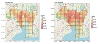
Module 4: Advanced Areal Interpolation: Pycnophylactic and Binary Dasymetric Methods
- Introduction to pycnophylactic interpolation for preserving total volume.
- Understanding the concept of dasymetric mapping.
- Binary dasymetric techniques using ancillary data
- Creating a density surface from source data.
- Iterative refinement processes.
- Case Study: Disaggregating county-level crime rates to a finer grid using a binary dasymetric approach based on land-use classifications
Module 5: Multifactor Dasymetric Mapping
- Utilizing multiple ancillary data layers for improved accuracy.
- Developing weighted dasymetric models based on land cover types, roads, and water bodies.
- Assigning weights to different ancillary categories.
- Handling diverse data formats and resolutions.
- Validation and error assessment for multifactor dasymetric maps.
- Case Study: Reallocating average household income from census tracts to smaller neighborhood units using detailed land cover, building type, and road network data.
Module 6: Geostatistical Areal Interpolation: Area-to-Point Kriging (ATPK)
- Introduction to geostatistics and spatial autocorrelation.
- Fundamentals of Kriging and its variants.
- Understanding Area-to-Point Kriging (ATPK).
- Modeling spatial dependency using variograms.
- Implementing ATPK in geostatistical software.
- Case Study: Estimating air pollution concentrations at unmonitored locations within specific administrative areas, starting from aggregated sensor data points.
Module 7: Geostatistical Areal Interpolation: Areal Kriging
- Concept of Areal Kriging for polygon-to-polygon interpolation.
- Differences between point and areal Kriging.
- Constructing block variograms from areal data.
- Predicting values for target polygons directly.
- Evaluating prediction uncertainty.
- Case Study: Interpolating soil nutrient levels from samples collected within agricultural fields (source polygons) to newly proposed cultivation zones
Module 8: Regression-Based Areal Interpolation
- Applying regression models for spatial data estimation.
- Using independent variables (ancillary data) to predict dependent variables.
- Geographically Weighted Regression (GWR) for localized relationships.
- Challenges of collinearity and spatial autocorrelation in regression.
- Model validation and residual analysis.
- Case Study: Estimating population density in small urban blocks using housing unit counts, building heights, and road network density as predictors.
Module 9: Spatial Aggregation Techniques
- Defining spatial aggregation and its purposes.
- Methods of aggregation: simple summation, averaging, and weighted averages.
- Aggregating point data to polygons.
- Aggregating polygon data to larger polygons.
- Considerations for preserving original data characteristics during aggregation.
- Case Study: Consolidating sales data from individual retail outlets (points) to city-level economic zones (polygons) for regional market analysis.
Module 10: Advanced Aggregation and Zone Design
- Optimal zoning and zone design methodologies.
- Clustering algorithms for creating homogeneous spatial units.
- Addressing the impact of MAUP through strategic aggregation.
- Techniques for creating new analytical units.
- Tools and software for advanced aggregation.
- Case Study: Redesigning police patrol zones to optimize response times based on aggregated crime incident data and road network topology.
Module 11: Data Validation and Error Assessment
- Importance of validation in spatial interpolation and aggregation.
- Quantitative error metrics (RMSE, MAE, R-squared).
- Visual inspection and qualitative assessment of results.
- Cross-validation techniques for model evaluation.
- Communicating uncertainty and confidence in spatial estimates.
- Case Study: Comparing the accuracy of different areal interpolation methods for estimating population in target zones against known validation data.
Module 12: Software Applications and Practical Implementation (e.g., ArcGIS Pro, QGIS, R/Python)
- Hands-on exercises with industry-standard GIS software.
- Utilizing geoprocessing tools for interpolation and aggregation.
- Scripting spatial workflows using Python (ArcPy, GeoPandas) or R (sp, sf, gstat).
- Automating repetitive tasks for large datasets.
- Troubleshooting common issues in software implementation.
- Case Study: Developing a Python script to automate the dasymetric mapping of demographic data for multiple years across changing administrative boundaries.
Module 13: Case Studies in Urban Planning and Demography
- Population estimation for disaster response and humanitarian aid.
- Small-area estimation of socio-economic indicators.
- Reconciling historical census boundaries for longitudinal studies.
- Analyzing demographic shifts at fine spatial scales.
- Predicting urban growth patterns.
- Case Study: Using areal interpolation to create detailed population grids for urban areas to inform emergency service planning and infrastructure development.
Module 14: Case Studies in Environmental Science and Public Health
- Mapping disease prevalence or environmental risks.
- Interpolating climate data from weather stations to ecological zones.
- Assessing exposure to environmental hazards.
- Analyzing resource distribution and access.
- Quantifying environmental impact at local scales.
- Case Study: Interpolating localized air quality data from sparse monitoring stations to estimate exposure risk for vulnerable populations in a city.
Module 15: Best Practices, Emerging Trends, and Future Directions
- Ethical considerations in spatial data handling and privacy.
- The role of big data and cloud computing in spatial analysis.
- Integration with Machine Learning and AI for advanced spatial prediction.
- Future trends in geospatial data science.
- Resources for continuous learning and professional development.
- Case Study: Discussion on the potential of integrating satellite imagery and deep learning for highly granular population distribution mapping in data-scarce regions.
Training Methodology
- Interactive Lectures.
- Software Demonstrations
- Guided Exercises.
- Case Study Analysis
- Group Discussions and Problem-Solving
- Individual Project Work.
- Q&A Sessions.
Register as a group from 3 participants for a Discount
Send us an email: info@datastatresearch.org or call +254724527104
Certification
Upon successful completion of this training, participants will be issued with a globally- recognized certificate.
Tailor-Made Course
We also offer tailor-made courses based on your needs.
Key Notes
a. The participant must be conversant with English.
b. Upon completion of training the participant will be issued with an Authorized Training Certificate
c. Course duration is flexible and the contents can be modified to fit any number of days.
d. The course fee includes facilitation training materials, 2 coffee breaks, buffet lunch and A Certificate upon successful completion of Training.
e. One-year post-training support Consultation and Coaching provided after the course.
f. Payment should be done at least a week before commence of the training, to DATASTAT CONSULTANCY LTD account, as indicated in the invoice so as to enable us prepare better for you.