Training Course on Advanced Hyperspectral and Multispectral Image Analysis
Training Course on Advanced Hyperspectral and Multispectral Image Analysis is meticulously designed to equip professionals with the theoretical foundations and practical skills necessary to effectively process, analyze, and interpret HSI and MSI data.
Course Overview
Training Course on Advanced Hyperspectral and Multispectral Image Analysis
Introduction
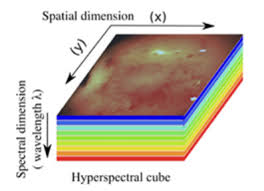
The rapidly evolving fields of remote sensing and precision analysis are being revolutionized by Hyperspectral (HSI) and Multispectral (MSI) imaging technologies. These advanced imaging modalities capture vast amounts of spectral information, extending beyond the visible light spectrum, to unveil hidden details about the composition and characteristics of targets. From environmental monitoring to precision agriculture, geological exploration, and defense applications, the ability to extract meaningful insights from this rich data is paramount for informed decision-making and driving innovation across diverse sectors.
Training Course on Advanced Hyperspectral and Multispectral Image Analysis is meticulously designed to equip professionals with the theoretical foundations and practical skills necessary to effectively process, analyze, and interpret HSI and MSI data. Participants will delve into the intricacies of spectral signatures, data pre-processing, feature extraction, and advanced machine learning algorithms tailored for high-dimensional imaging. Through hands-on exercises and real-world case studies, attendees will gain proficiency in leveraging these powerful tools to address complex challenges and unlock unprecedented analytical capabilities in their respective domains.
Course Duration
5 days
Course Objectives
Upon completion of this course, participants will be able to:
- Master the fundamental principles of Hyperspectral and Multispectral Remote Sensing.
- Differentiate between HSI and MSI data characteristics, strengths, and limitations for various real-world applications.
- Perform essential radiometric and atmospheric corrections on HSI/MSI data for accurate analysis.
- Implement diverse spectral indices (e.g., NDVI, EVI) for robust vegetation health assessment and land cover mapping.
- Apply advanced dimensionality reduction techniques (e.g., PCA, MNF) to efficiently manage high-dimensional spectral data.
- Execute various spectral unmixing algorithms to identify and quantify pure materials within mixed pixels.
- Utilize machine learning and deep learning architectures (e.g., CNNs) for sophisticated spectral classification and object detection.
- Develop custom spectral libraries for enhanced material identification and target discrimination.
- Interpret spectral signatures to identify specific minerals, pollutants, crop stresses, and other critical features.
- Integrate HSI/MSI data with other geospatial datasets like LiDAR for comprehensive 3D spatial analysis.
- Assess the quality and accuracy of HSI/MSI analysis results using appropriate validation metrics.
- Leverage industry-standard image processing software (e.g., ENVI, ArcGIS, QGIS with plugins) for practical workflows.
- Design and implement effective workflows for HSI/MSI data analysis in their specific industry domains.
Organizational Benefits
- Access to more precise and detailed spatial and spectral information leads to better-informed strategic and operational decisions in areas like resource management, environmental protection, and infrastructure planning.
- Improved accuracy in identifying and quantifying resources (e.g., crop yield, mineral deposits) enables more efficient allocation and reduced waste.
- The ability to detect subtle anomalies, diseases, or environmental stresses early can prevent significant losses and enable proactive interventions.
- Streamlined data processing and analysis workflows lead to faster insights and reduced manual effort.
- Equipping staff with cutting-edge HSI/MSI analysis skills fosters innovation and provides a distinct advantage in a rapidly evolving technological landscape.
- Better monitoring capabilities for environmental impact, safety hazards, and regulatory adherence.
- Development of novel products and services leveraging the unique capabilities of hyperspectral and multispectral data.
Target Audience
- GIS Professionals & Remote Sensing Analysts.
- Environmental Scientists & Ecologists.
- Agricultural Engineers & Agronomists.
- Geologists & Mining Engineers.
- Urban Planners & Civil Engineers.
- Researchers & Academics.
- Defense & Security Analysts.
- Data Scientists & Machine Learning Engineers
Course Outline
Module 1: Fundamentals of Spectral Imaging and Remote Sensing
- Introduction to Electromagnetic Spectrum and Spectral Reflectance.
- Distinction between Multispectral and Hyperspectral Imaging: Theory and Applications.
- Overview of Sensor Technologies: Airborne, Satellite, and UAV-based platforms.
- Understanding Spectral Signatures and their significance in material identification.
- Case Study: Identifying different land cover types (forest, water, urban) using Sentinel-2 MSI data.
Module 2: Data Pre-processing and Radiometric Correction
- Raw Data to Usable Information: Conversion of Digital Numbers (DN) to Radiance/Reflectance.
- Atmospheric Correction Techniques: FLAASH, ATCOR, and empirical line correction.
- Geometric Correction and Image Registration for spatial accuracy.
- Noise Reduction and Data Quality Assessment
- Case Study: Correcting atmospheric effects on AVIRIS hyperspectral data for mineral mapping in arid regions.
Module 3: Spectral Enhancement and Feature Extraction
- Vegetation Indices: NDVI, EVI, SAVI, and their applications in agricultural monitoring.
- Mineral Indices: Hydroxyl, Ferrous Mineral indices for geological exploration.
- Spectral Ratios and Transformations for highlighting specific features.
- Continuum Removal and Spectral Curve Analysis for detailed spectral characterization.
- Case Study: Monitoring crop stress and nitrogen deficiency in a cornfield using various vegetation indices derived from drone-based MSI.
Module 4: Dimensionality Reduction Techniques
- The Curse of Dimensionality in Hyperspectral Data.
- Principal Component Analysis (PCA): Theory and Application for data compression and noise reduction.
- Minimum Noise Fraction (MNF) Transformation for spectral purity and data visualization.
- Independent Component Analysis (ICA) and its role in separating mixed signals.
- Case Study: Reducing the dimensionality of HyMap data for efficient processing in a forestry inventory project.
Module 5: Spectral Unmixing and Abundance Mapping
- Linear Spectral Unmixing Model: Theory and Assumptions.
- Endmember Extraction Algorithms: Pixel Purity Index (PPI), N-FINDR, VCA.
- Sub-pixel Mapping and Abundance Fraction Estimation.
- Spectral Mixture Analysis (SMA) for quantifying material proportions.
- Case Study: Mapping the abundance of different soil components (e.g., sand, clay, organic matter) in agricultural fields using HSI.
Module 6: Supervised and Unsupervised Classification
- Supervised Classification: Training Data Collection, Feature Selection, and Classifier Training.
- Common Classifiers: Support Vector Machines (SVM), Random Forest, K-Nearest Neighbors (KNN).
- Unsupervised Classification: K-Means, ISODATA, and their applications.
- Accuracy Assessment: Confusion Matrix, Producer's, User's, and Overall Accuracy, Kappa Coefficient.
- Case Study: Classifying different rock types and alteration zones in a geological setting using ASTER multispectral data and SVM.
Module 7: Advanced Machine Learning and Deep Learning for HSI/MSI
- Introduction to Machine Learning in Remote Sensing.
- Deep Learning Architectures: Convolutional Neural Networks (CNNs) for spectral-spatial classification.
- Object-Based Image Analysis (OBIA) combining spectral and spatial information.
- Integration of HSI/MSI with other data sources (e.g., LiDAR, DEM).
- Case Study: Detecting and classifying different types of plastic waste on a beach using a deep learning model trained on drone-acquired HSI data.
Module 8: Practical Applications and Workflow Development
- Application of HSI/MSI in Precision Agriculture: Disease detection, yield prediction, water stress.
- Environmental Monitoring: Pollution mapping, water quality assessment, ecological surveys.
- Geological and Mineral Mapping: Identifying mineral deposits, geological structures.
- Defense and Security: Target identification, camouflage detection.
- Case Study: Developing a complete workflow for monitoring invasive species spread in a wetland ecosystem using a combination of MSI data and object-based classification.
Training Methodology
This training course employs a highly interactive and practical methodology to ensure maximum learning and skill acquisition. It combines:
- Instructor-Led Presentations: Clear and concise explanations of theoretical concepts.
- Hands-on Software Exercises: Extensive practical sessions using industry-standard software (e.g., ENVI, ArcGIS Pro with Image Analyst extension, Python libraries like scikit-image, rasterio, spectral).
- Real-World Case Studies: In-depth analysis of diverse applications to solidify understanding and demonstrate practical utility.
- Group Discussions and Problem Solving: Encouraging collaborative learning and critical thinking.
- Practical Demonstrations: Live demonstrations of complex analysis workflows.
- Q&A Sessions: Dedicated time for addressing participant queries and fostering deeper understanding.
- Individualized Feedback: Personalized guidance during practical exercises.
Register as a group from 3 participants for a Discount
Send us an email: info@datastatresearch.org or call +254724527104
Certification
Upon successful completion of this training, participants will be issued with a globally- recognized certificate.
Tailor-Made Course
We also offer tailor-made courses based on your needs.
Key Notes
a. The participant must be conversant with English.
b. Upon completion of training the participant will be issued with an Authorized Training Certificate
c. Course duration is flexible and the contents can be modified to fit any number of days.
d. The course fee includes facilitation training materials, 2 coffee breaks, buffet lunch and A Certificate upon successful completion of Training.
e. One-year post-training support Consultation and Coaching provided after the course.
f. Payment should be done at least a week before commence of the training, to DATASTAT CONSULTANCY LTD account, as indicated in the invoice so as to enable us prepare better for you.