Time-Series Analysis of Geospatial Data Training Course
This program emphasizes a hands-on learning approach, leveraging cutting-edge GIS software and Time-Series Analysis of Geospatial Data Training Course programming tools to analyze real-world satellite imagery, sensor data, and other geolocated time-series data.
Course Overview
Time-Series Analysis of Geospatial Data Training Course
Introduction
In an increasingly data-driven world, the ability to extract meaningful insights from vast and complex datasets is paramount. Geospatial data, with its inherent spatial and temporal dimensions, offers a unique lens through which to understand our dynamic planet. This intensive training course delves into the critical discipline of Time-Series Analysis of Geospatial Data, equipping participants with advanced methodologies and practical skills to unlock the predictive power embedded within sequential geographic information. We will explore how spatiotemporal patterns reveal crucial trends, anomalies, and relationships, enabling informed decision-making across diverse sectors from environmental monitoring to urban planning and disaster response.
This program emphasizes a hands-on learning approach, leveraging cutting-edge GIS software and Time-Series Analysis of Geospatial Data Training Course programming tools to analyze real-world satellite imagery, sensor data, and other geolocated time-series data. Participants will gain a deep understanding of concepts like trend detection, seasonality analysis, forecasting models, and anomaly detection in a geospatial context, preparing them to tackle complex challenges and drive impactful solutions in their respective fields.
Course Duration
5 days
Course Objectives
Upon completion of this course, participants will be able to:
- Master the fundamental concepts of geospatial time-series data and its unique characteristics.
- Identify and apply appropriate data structures and formats for spatiotemporal analysis.
- Perform comprehensive data preprocessing and cleaning on geospatial time-series datasets.
- Utilize various techniques for trend analysis and seasonality decomposition in geographical contexts.
- Implement and evaluate advanced forecasting models for geospatial phenomena.
- Detect and interpret anomalies and outliers in time-series geospatial data.
- Apply spatial statistics and machine learning algorithms to time-series challenges.
- Leverage open-source GIS tools and Python libraries for practical time-series analysis.
- Develop and execute robust spatiotemporal analysis workflows.
- Communicate insights effectively through advanced geospatial visualization techniques.
- Assess the uncertainty and accuracy associated with geospatial time-series predictions.
- Explore real-world case studies demonstrating the impact of geospatial time-series analysis.
- Design and implement a mini-project applying learned skills to a specific geospatial time-series problem.
Organizational Benefits
- Data-driven insights from spatiotemporal patterns lead to more informed strategic and operational decisions.
- Accurate forecasting of geospatial trends, risks, and opportunities.
- Better planning and deployment of resources based on anticipated changes.
- Early identification of critical issues or deviations in real-world processes.
- Streamlined workflows for managing and analyzing complex geospatial datasets.
- Leverage cutting-edge analytical techniques for innovation and market leadership.
- Better assessment and mitigation of location-based risks over time.
- Empowering teams with high-demand expertise in geospatial data science.
Target Audience
- GIS Analysts and Specialists
- Environmental Scientists and Researchers
- Urban Planners and Policy Makers
- Data Scientists and Analysts
- Remote Sensing Professionals
- Disaster Management and Humanitarian Aid Workers
- Agricultural Scientists and Agronomists
- Researchers in Geography, Ecology, and Earth Sciences
Course Ouline
Module 1: Foundations of Geospatial Time-Series Data
- Introduction to Geospatial Data Types: Vector, Raster, Point Clouds.
- Understanding the Temporal Dimension in Spatial Data.
- Key Concepts: Spatiotemporal Data Cubes, Event-Based Data.
- Coordinate Reference Systems and Temporal Alignment.
- Case Study: Tracking forest cover change using multi-temporal satellite imagery.
Module 2: Data Acquisition and Preprocessing for Time-Series Analysis
- Sources of Geospatial Time-Series Data: Satellite Missions (Landsat, Sentinel), IoT Sensors, GPS Tracks.
- Data Ingestion and Management in GIS Environments.
- Data Cleaning Techniques: Handling Missing Values, Outliers, Noise Reduction.
- Resampling and Aggregation of Time-Series Geospatial Data.
- Case Study: Preparing weather station data for climate change analysis, addressing data gaps and inconsistencies.
Module 3: Exploratory Spatiotemporal Data Analysis (ESTDA)
- Visualizing Time-Series Geospatial Data: Animations, Time-Space Cubes.
- Trend Identification: Linear, Non-linear, and Piecewise Trends.
- Seasonality and Cyclical Patterns: Detection and Decomposition.
- Autocorrelation and Partial Autocorrelation Functions in Space and Time.
- Case Study: Analyzing urban heat island effect over decades using thermal imagery and identifying seasonal variations.
Module 4: Traditional Time-Series Forecasting Models
- ARIMA, SARIMA, and ARIMAX Models for Spatiotemporal Data.
- Exponential Smoothing Methods (ETS) in a Geographic Context.
- Model Selection and Evaluation Metrics (RMSE, MAE, R-squared).
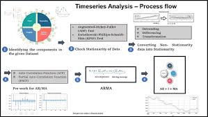
- Handling Non-Stationarity in Geospatial Time Series.
- Case Study: Forecasting regional crop yields based on historical satellite vegetation indices and weather data.
Module 5: Advanced Statistical and Machine Learning Approaches
- Regression Models with Spatiotemporal Lags.
- Machine Learning for Time Series: Random Forests, Gradient Boosting.
- Introduction to Deep Learning for Spatiotemporal Data: LSTMs, CNNs.
- Feature Engineering from Geospatial Time Series.
- Case Study: Predicting wildfire spread using historical fire perimeters, land cover, and meteorological time-series data with machine learning.
Module 6: Anomaly Detection in Geospatial Time Series
- Methods for Outlier Detection: Statistical and Rule-Based Approaches.
- Change Detection Algorithms in Remote Sensing Time Series.
- Spatiotemporal Hotspot Analysis for Anomalies.
- Alerting and Real-Time Monitoring Applications.
- Case Study: Identifying illegal deforestation events using satellite imagery time series and anomaly detection.
Module 7: Practical Applications and Case Studies
- Environmental Monitoring: Water quality, air pollution, land degradation.
- Urban Dynamics: Population movement, infrastructure development, traffic flow.
- Disaster Risk Reduction: Flood mapping, earthquake impact, early warning systems.
- Precision Agriculture: Crop health monitoring, irrigation optimization.
- Case Study: Analyzing mobility patterns during a pandemic using aggregated cell phone data to inform public health interventions.
Module 8: Project Development and Best Practices
- Workflow Design for End-to-End Geospatial Time-Series Projects.
- Data Storytelling and Interactive Visualization of Spatiotemporal Insights.
- Ethical Considerations and Data Privacy in Geospatial Analytics.
- Scalability and Cloud Computing for Big Geospatial Data.
- Case Study: Participants present their individual or group mini-projects, showcasing applied skills and critical analysis.
Training Methodology
This course employs a highly interactive and practical training methodology, combining:
- Instructor-Led Presentations: Clear explanations of core concepts and theories.
- Hands-on Practical Exercises: Extensive use of open-source software (e.g., QGIS, GRASS GIS) and Python libraries
- Real-World Case Studies: In-depth analysis and discussion of practical applications across various domains.
- Live Coding Demonstrations: Step-by-step guidance on implementing analytical techniques.
- Group Discussions and Collaborative Problem-Solving: Fostering peer learning and critical thinking.
- Mini-Project: Participants will work on a practical project applying learned skills to a dataset of their choice (or provided by the instructor), culminating in a presentation.
- Q&A Sessions: Opportunities for clarification and in-depth exploration of topics.
Register as a group from 3 participants for a Discount
Send us an email: [email protected] or call +254724527104
Certification
Upon successful completion of this training, participants will be issued with a globally- recognized certificate.
Tailor-Made Course
We also offer tailor-made courses based on your needs.
Key Notes
a. The participant must be conversant with English.
b. Upon completion of training the participant will be issued with an Authorized Training Certificate
c. Course duration is flexible and the contents can be modified to fit any number of days.
d. The course fee includes facilitation training materials, 2 coffee breaks, buffet lunch and A Certificate upon successful completion of Training.
e. One-year post-training support Consultation and Coaching provided after the course.
f. Payment should be done at least a week before commence of the training, to DATASTAT CONSULTANCY LTD account, as indicated in the invoice so as to enable us prepare better for you.