Thermal Remote Sensing and Heat Island Analysis Training Course
Thermal Remote Sensing & Heat Island Analysis Training Course provides a comprehensive understanding of Thermal Remote Sensing principles and their application in Urban Heat Island (UHI) analysis.
Course Overview
Thermal Remote Sensing & Heat Island Analysis Training Course
Introduction
Thermal Remote Sensing & Heat Island Analysis Training Course provides a comprehensive understanding of Thermal Remote Sensing principles and their application in Urban Heat Island (UHI) analysis. Participants will delve into the physics of thermal radiation, sensor technologies, and advanced image processing techniques to accurately map and monitor land surface temperatures. The curriculum emphasizes practical skills for data acquisition, analysis, and interpretation, equipping professionals to address critical environmental challenges posed by urbanization and climate change.
Through hands-on exercises and real-world case studies, this course will empower participants to leverage thermal remote sensing for effective urban planning, environmental management, and the development of sustainable urban solutions. You'll gain expertise in identifying UHI hotspots, assessing their impacts, and formulating mitigation strategies using cutting-edge geospatial tools and data analytics. This training is essential for anyone seeking to contribute to resilient urban development and a healthier planet.
Course Duration
10 days
Course Objectives
Upon completion of this course, participants will be able to:
- Understand the fundamental principles of thermal infrared remote sensing and its unique capabilities.
- Identify various thermal sensors and platforms (satellite, UAV, aerial) used for UHI studies.
- Acquire and process thermal remote sensing data for accurate Land Surface Temperature (LST) retrieval.
- Master techniques for urban heat island mapping and spatial analysis.
- Analyze the drivers and impacts of urban heat islands on human health, energy consumption, and biodiversity.
- Apply advanced image processing algorithms for thermal data enhancement and classification.
- Utilize Geographic Information Systems (GIS) for integrating and visualizing thermal data with other geospatial datasets.
- Evaluate different UHI mitigation strategies and their effectiveness using remote sensing.
- Conduct change detection analysis of urban thermal environments over time.
- Develop predictive models for urban thermal behavior and future UHI scenarios.
- Interpret thermal anomalies and identify potential environmental risks.
- Formulate data-driven recommendations for sustainable urban development and climate resilience.
- Communicate complex thermal remote sensing findings to diverse stakeholders.
Organizational Benefits
- Improved capacity to make informed decisions regarding urban planning, infrastructure development, and environmental policy based on accurate thermal data.
- Ability to monitor and assess urban heat conditions proactively, leading to optimized energy consumption and reduced costs associated with heat-related health issues.
- Development of strategies for creating more sustainable and climate-resilient cities by mitigating urban heat island effects.
- Equipping staff with cutting-edge skills in a rapidly evolving field, fostering innovation and leadership in geospatial analysis and environmental management.
- Contribution to better public health outcomes by identifying and addressing heat-vulnerable areas within urban environments.
- Strengthened capabilities for environmental impact assessments and reporting, meeting regulatory requirements related to climate change and urban development.
Target Audience
- Urban Planners and City Managers
- Environmental Scientists and Ecologists
- GIS Analysts and Remote Sensing Professionals
- Climate Change Researchers and Consultants
- Civil Engineers and Infrastructure Developers
- Public Health Officials and Urban Health Specialists
- Academics and Students in Geography, Environmental Science, or related field
- Government Agency Staff
Course Outline
Module 1: Introduction to Thermal Remote Sensing
- Fundamentals of Electromagnetic Radiation: Understanding the physics of thermal energy and its interaction with surfaces.
- Thermal Infrared Spectrum: Exploring the atmospheric windows and spectral characteristics relevant to thermal imaging.
- Thermal Sensors and Platforms: Overview of common satellite (Landsat, MODIS, ASTER), aerial, and UAV thermal sensors.
- Applications of Thermal Remote Sensing: Diverse uses in environmental monitoring, urban studies, agriculture, and disaster management.
- Data Characteristics: Spatial, spectral, temporal, and radiometric resolution of thermal datasets.
- Case Study: Detecting Heat Signatures of Volcanic Activity using MODIS Data.
Module 2: Principles of Urban Heat Islands
- Definition and Types of Urban Heat Islands: Surface UHI vs. Atmospheric UHI.
- Factors Influencing UHI Formation: Urban morphology, materials, vegetation cover, anthropogenic heat.
- Impacts of UHIs: Energy consumption, air quality, human health, and ecosystem stress.
- Measurement Techniques: Traditional ground-based measurements versus remote sensing approaches.
- Global and Local UHI Phenomena: Examples from different climatic zones.
- Case Study: Analyzing the UHI Effect in a Megacity (e.g., Cairo or Mumbai) using long-term Landsat archives.
Module 3: Thermal Data Acquisition and Pre-processing
- Data Sources: Accessing freely available thermal satellite imagery and commercial data.
- Radiometric Calibration: Converting digital numbers (DN) to radiance values.
- Atmospheric Correction: Techniques to remove atmospheric effects for accurate temperature retrieval.
- Geometric Correction and Registration: Aligning thermal imagery with other geospatial data.
- Image Enhancement Techniques: Contrast stretching, filtering, and false-color composites.
- Case Study: Pre-processing Landsat 8 TIRS data for LST retrieval over a study area.
Module 4: Land Surface Temperature (LST) Retrieval Algorithms
- Mono-Window Algorithm: Theory and application for single-band thermal data.
- Split-Window Algorithm: Utilizing two thermal bands for improved accuracy (e.g., Landsat 7 ETM+, Landsat 8 TIRS).
- Radiative Transfer Equation Methods: Advanced techniques for precise LST estimation.
- Emissivity Estimation: Importance of surface emissivity and methods for its determination.
- Validation of LST Products: Comparing remote sensing-derived LST with ground truth measurements.
- Case Study: Comparing LST retrieval using Mono-Window and Split-Window algorithms in an urban environment.
Module 5: Urban Heat Island Mapping and Analysis
- Spatial Distribution of UHIs: Identifying hot and cool spots within urban landscapes.
- Quantifying UHI Intensity: Calculating temperature differences between urban and rural areas.
- Temporal Dynamics of UHIs
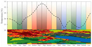
- Relationship with Land Cover/Land Use (LCLU): Investigating the influence of impervious surfaces, vegetation, and water bodies.
- Heat Vulnerability Mapping: Combining LST with socioeconomic and demographic data.
- Case Study: Mapping and analyzing UHI patterns in Kisumu, Kenya, relating them to informal settlements and green spaces.
Module 6: Advanced Image Processing for Thermal Data
- Image Segmentation: Delineating urban features for detailed thermal analysis.
- Object-Based Image Analysis (OBIA): Analyzing thermal characteristics of individual objects.
- Machine Learning and Deep Learning: Applications in thermal data classification and pattern recognition.
- Spatial Interpolation Techniques: Creating continuous temperature surfaces from discrete data points.
- Thermal Anomaly Detection: Identifying unusual heat signatures for specific applications (e.g., pipeline leaks).
- Case Study: Using OBIA to characterize thermal properties of different building types in a central business district.
Module 7: Integration with Geographic Information Systems (GIS)
- GIS Data Models for Thermal Analysis: Raster and vector data integration.
- Spatial Joins and Overlay Analysis: Combining thermal data with other geographic layers (e.g., population density, transportation networks).
- Network Analysis for Heat Exposure: Assessing heat exposure along pedestrian routes.
- 3D Visualization of Urban Thermal Environments: Creating realistic models of urban heat distribution.
- Geospatial Databases: Managing and organizing large thermal datasets.
- Case Study: Integrating LST maps with urban infrastructure data in ArcGIS Pro to identify heat-stressed neighborhoods.
Module 8: Drivers and Mitigations of Urban Heat Islands
- Green Infrastructure Solutions: Role of urban forests, parks, and green roofs in cooling cities.
- Cool Materials and Reflective Surfaces: Impact of albedo on urban temperatures.
- Urban Geometry and Ventilation: Influence of building height and street canyon effects.
- Water Bodies and Evaporative Cooling: The role of lakes, rivers, and fountains.
- Policy and Planning Interventions: Strategies for integrating UHI mitigation into urban development plans.
- Case Study: Assessing the cooling effect of a newly implemented urban park using pre and post-green space LST data.
Module 9: Change Detection and Trend Analysis
- Temporal Stacking of Thermal Images: Monitoring LST changes over seasons and years.
- Statistical Change Detection Methods: Analyzing significant temperature shifts.
- Urban Growth and UHI Expansion: Correlating urbanization patterns with heat island intensity.
- Attributing LST Changes: Identifying the factors contributing to observed thermal trends.
- Forecasting Future UHI Scenarios: Using models to predict thermal changes under different development pathways.
- Case Study: Analyzing the urban expansion and corresponding UHI increase in a rapidly growing city over two decades.
Module 10: Advanced Applications and Case Studies
- Energy Consumption Analysis: Estimating building energy use based on thermal signatures.
- Air Quality and UHI Interactions: Understanding the link between heat and pollutant dispersion.
- Public Health Impacts of Extreme Heat: Identifying vulnerable populations and areas.
- Biodiversity and UHI: Effects of elevated temperatures on urban flora and fauna.
- Disaster Management: Using thermal data for wildfire detection, search and rescue, and infrastructure monitoring.
- Case Study: Utilizing thermal imaging to assess the impact of UHI on energy demand in residential areas.
Module 11: Data Visualization and Reporting
- Effective Mapping Techniques: Creating clear and informative LST and UHI maps.
- Interactive Dashboards: Developing tools for dynamic visualization and exploration of thermal data.
- Statistical Graphics: Presenting quantitative UHI data through charts and graphs.
- Storytelling with Geospatial Data: Communicating complex findings to non-technical audiences.
- Best Practices for Technical Reports: Structuring and writing comprehensive reports on thermal analyses.
- Case Study: Creating an interactive web map showcasing UHI hotspots and potential mitigation zones for a local government.
Module 12: Future Trends and Emerging Technologies
- Satellite Constellations: High-resolution thermal data from new sensor missions.
- Thermal Drones (UAVs): High-resolution, on-demand thermal data for localized studies.
- Integration with IoT and Smart City Platforms: Real-time urban temperature monitoring.
- Artificial Intelligence and Big Data: Leveraging advanced computing for large-scale thermal analysis.
- Open-Source Tools and Platforms: Exploring new software and resources for thermal remote sensing.
- Case Study: Discussing the potential of drone-based thermal surveys for micro-UHI assessment in a specific urban precinct.
Module 13: Practical Project and Capstone
- Problem Identification: Defining a relevant UH