Hotspot Analysis and Clustering for Spatial Patterns Training Course
Hotspot Analysis and Clustering for Spatial Patterns Training Course equips professionals with advanced spatial analytical skills to identify, interpret, and leverage hotspots and spatial clusters in diverse datasets.
Course Overview
Hotspot Analysis and Clustering for Spatial Patterns Training Course
Introduction
Hotspot Analysis and Clustering for Spatial Patterns Training Course equips professionals with advanced spatial analytical skills to identify, interpret, and leverage hotspots and spatial clusters in diverse datasets. In today's data-driven world, understanding the geographic distribution of phenomena is paramount for effective decision-making. From crime analysis to disease outbreak detection, urban planning, and resource allocation, mastering the techniques of hotspot analysis and clustering empowers individuals and organizations to uncover critical spatial patterns, predict trends, and implement targeted interventions, ultimately leading to more informed and impactful strategies.
Participants will delve into cutting-edge geospatial methodologies and gain hands-on experience with industry-standard GIS software and programming tools. The curriculum emphasizes practical application, ensuring that learners can confidently apply various clustering algorithms and spatial statistics like Getis-Ord Gi* and Kernel Density Estimation. By focusing on real-world case studies and interactive exercises, this training fosters a deep understanding of how to transform raw spatial data into actionable intelligence, enabling proactive problem-solving and optimizing resource deployment across a multitude of sectors.
Course Duration
5 days
Course Objectives
- Comprehend the intricacies of spatial data types, coordinate systems, and data acquisition for robust analysis.
- Utilize Getis-Ord Gi* and Moran's I to statistically identify significant spatial clusters and outliers.
- Generate accurate density maps to visualize hot and cold spots of various phenomena.
- Apply K-means, DBSCAN, Hierarchical Clustering, and Spatial Scan Statistics for effective data segmentation.
- Detect evolving patterns and dynamic hotspots for proactive intervention and forecasting.
- Strategically deploy resources based on evidence-based spatial insights.
- Uncover crime hotspots and inform targeted policing strategies.
- Identify pollution clusters and assess the spatial impact of environmental factors.
- Pinpoint disease clusters and support rapid response in epidemiology.
- Inform infrastructure development and community initiatives by understanding urban spatial dynamics.
- Create compelling and informative maps, dashboards, and reports for diverse stakeholders.
- Explore the synergy of AI with traditional spatial methods for predictive modeling.
- Leverage spatial insights to build robust analytical models for organizational impact.
Organizational Benefits
- Data-driven insights lead to more effective and targeted strategies across departments.
- Efficient allocation of personnel, funding, and assets to areas of greatest need.
- Early identification of issues and emerging trends allows for timely interventions.
- Better understanding of spatial risks enables informed mitigation strategies.
- Streamlined workflows through automated spatial analysis and visualization.
- Policies and programs are grounded in objective spatial evidence, leading to greater impact.
- Leveraging spatial intelligence provides a unique edge in market analysis, site selection, and service delivery.
- Empowering a wider range of staff with spatial analysis skills, fostering a data-centric culture.
Target Audience
- Urban Planners & City Managers.
- Law Enforcement & Crime Analysts.
- Public Health Professionals & Epidemiologists.
- Environmental Scientists & Conservationists.
- Researchers & Academics.
- Data Scientists & Business Intelligence Analysts.
- Emergency Management & Disaster Response Teams
- GIS Specialists & Geospatial Analysts.
Course Outline
Module 1: Foundations of Spatial Data and GIS for Hotspot Analysis
- Introduction to Geospatial Data Models
- Coordinate Systems and Projections
- GIS Software Essentials.
- Data Preparation and Cleaning
- Case Study: Analyzing emergency call locations in a city for data quality assessment and initial spatial exploration.
Module 2: Unveiling Spatial Autocorrelation
- Concepts of Spatial Autocorrelation.
- Global Indicators of Spatial Association
- Interpreting Correlograms and Variograms.
- Testing for Statistical Significance.
- Case Study: Assessing the spatial autocorrelation of unemployment rates across different urban neighborhoods to identify overall patterns of economic disparity.
Module 3: Introduction to Hotspot Analysis (Getis-Ord Gi)*
- Understanding Getis-Ord Gi Statistic.
- Defining Neighborhood Relationships
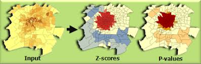
- Interpreting Z-scores and P-values.
- Optimized Hotspot Analysis.
- Case Study: Identifying statistically significant clusters of traffic accidents on a city's road network to inform road safety improvements.
Module 4: Density-Based Hotspot Mapping
- Principles of Kernel Density Estimation.
- Choosing Kernel Functions and Bandwidth
- Visualizing Density Hotspots.
- Comparing KDE with Getis-Ord Gi.
- Case Study: Mapping the density of retail stores in a metropolitan area to identify commercial activity hotspots for new business development.
Module 5: Spatial Clustering Algorithms
- K-means Clustering for Spatial Data.
- DBSCAN (Density-Based Spatial Clustering of Applications with Noise)
- Hierarchical Clustering.
- Introduction to Spatial Scan Statistics
- Case Study: Clustering customer locations based on purchasing behavior and demographics to inform targeted marketing campaigns.
Module 6: Advanced Spatial Pattern Analysis Techniques
- Space-Time Hotspot Analysis.
- Outlier Analysis (Anselin Local Moran's I)
- Network-Constrained Hotspot Analysis
- Regression Analysis with Spatial Lag Models.
- Case Study: Analyzing the spatio-temporal patterns of a specific crime type (e.g., burglaries) to understand crime trends and inform resource deployment strategies over time.
Module 7: Visualizing and Communicating Spatial Insights
- Principles of Cartographic Design.
- Interactive Mapping and Web GIS.
- Dashboarding for Spatial Data.
- Story Mapping.
- Case Study: Developing an interactive web map dashboard visualizing public health intervention hotspots and their correlation with health outcomes for public outreach and policy advocacy.
Module 8: Practical Applications and Future Trends in Spatial Analytics
- Industry-Specific Case Studies.
- Integrating Spatial Analysis with Big Data.
- Introduction to Machine Learning for Spatial Prediction:
- Ethical Considerations in Spatial Analysis.
- Case Study: A comprehensive project where participants apply multiple techniques to a real-world problem
Training Methodology
This training employs a highly interactive and hands-on methodology designed for practical skill development.
- Interactive Lectures: Concise presentations of theoretical concepts, followed by open discussions.
- Software Demonstrations: Live walkthroughs of tools and techniques using leading GIS software (e.g., ArcGIS Pro, QGIS).
- Hands-on Exercises: Practical assignments and guided labs applying concepts to real-world datasets.
- Case Study Analysis: In-depth examination of successful applications of hotspot analysis and clustering across various domains.
- Group Discussions & Problem Solving: Collaborative sessions to discuss challenges and solutions.
- Q&A Sessions: Dedicated time for addressing participant queries and clarifying concepts.
- Project-Based Learning: A culminating project where participants apply learned skills to a complex spatial problem.
- Resource Sharing: Access to course materials, datasets, and recommended readings for continued learning.
Register as a group from 3 participants for a Discount
Send us an email: info@datastatresearch.org or call +254724527104
Certification
Upon successful completion of this training, participants will be issued with a globally- recognized certificate.
Tailor-Made Course
We also offer tailor-made courses based on your needs.
Key Notes
a. The participant must be conversant with English.
b. Upon completion of training the participant will be issued with an Authorized Training Certificate
c. Course duration is flexible and the contents can be modified to fit any number of days.
d. The course fee includes facilitation training materials, 2 coffee breaks, buffet lunch and A Certificate upon successful completion of Training.
e. One-year post-training support Consultation and Coaching provided after the course.
f. Payment should be done at least a week before commence of the training, to DATASTAT CONSULTANCY LTD account, as indicated in the invoice so as to enable us prepare better for you.