gis Courses
Comprehensive gis training programs for professionals
Comprehensive gis training programs for professionals
Training Course on Big Geospatial Data Analytics with Spark and Hadoop provides a comprehensive understanding of distributed computing frameworks for geospatial applications.
Training Course on Big Geospatial Data Analytics with Spark and Hadoop provides a comprehensive understanding of distributed computing frameworks for geospatial applications.
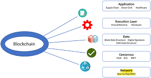
Training Course on Blockchain for Geospatial Data Management and Security. provides an in-depth exploration of how blockchain technology is revolutionizing geospatial data management and security
Training Course on Blockchain for Geospatial Data Management and Security. provides an in-depth exploration of how blockchain technology is revolutionizing geospatial data management and security
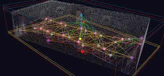
Training Course on Advanced Topology and Geometric Networks is designed for professionals seeking to master the analytical tools essential for navigating the complexities of modern data landscapes.
Training Course on Advanced Topology and Geometric Networks is designed for professionals seeking to master the analytical tools essential for navigating the complexities of modern data landscapes.
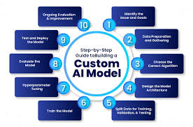
Training Course on Building Custom AI Models for GIS Workflows is meticulously designed to equip GIS professionals, data scientists, and spatial analysts with the cutting-edge skills required to develop and integrate custom Artificial Intelligence (AI) models directly into their Geospatial Information Systems (GIS) workflows.
Training Course on Building Custom AI Models for GIS Workflows is meticulously designed to equip GIS professionals, data scientists, and spatial analysts with the cutting-edge skills required to develop and integrate custom Artificial Intelligence (AI) models directly into their Geospatial Information Systems (GIS) workflows.
Building Custom Spatial Algorithms with Python Training Course is meticulously designed to equip professionals with the advanced Python programming skills necessary to develop, implement, and optimize custom spatial algorithms.
Building Custom Spatial Algorithms with Python Training Course is meticulously designed to equip professionals with the advanced Python programming skills necessary to develop, implement, and optimize custom spatial algorithms.
Training Course on Building Custom Widgets and Tools for Web GIS is designed to equip participants with the essential skills and knowledge to develop custom widgets and powerful geospatial tools for Web GIS applications.
Training Course on Building Custom Widgets and Tools for Web GIS is designed to equip participants with the essential skills and knowledge to develop custom widgets and powerful geospatial tools for Web GIS applications.
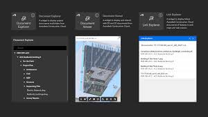
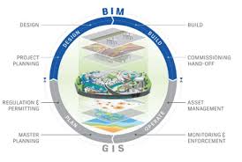
Training Course on Building Information Modeling and GIS Integration equips AEC professionals with the essential skills to seamlessly merge these transformative technologies, driving enhanced project lifecycle management, sustainable urban development, and data-driven decision-making.
Training Course on Building Information Modeling and GIS Integration equips AEC professionals with the essential skills to seamlessly merge these transformative technologies, driving enhanced project lifecycle management, sustainable urban development, and data-driven decision-making.
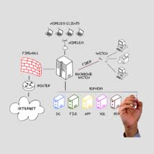
Training Course on Building RESTful Geospatial APIs goes beyond theoretical concepts, offering hands-on experience in building high-performance geospatial APIs that seamlessly integrate with various applications and platforms.
Training Course on Building RESTful Geospatial APIs goes beyond theoretical concepts, offering hands-on experience in building high-performance geospatial APIs that seamlessly integrate with various applications and platforms.
Training Course on Quantum Computing in Geospatial Science bridges the gap between theoretical quantum concepts and their practical applications within GIS and remote sensing.
Training Course on Quantum Computing in Geospatial Science bridges the gap between theoretical quantum concepts and their practical applications within GIS and remote sensing.
Training Course on Raster Data Processing and Advanced Manipulation focuses on practical, hands-on application of geospatial tools and programming languages for raster analytics.
Training Course on Raster Data Processing and Advanced Manipulation focuses on practical, hands-on application of geospatial tools and programming languages for raster analytics.
Training Course on Real-Time Geospatial Analytics with Stream Processing provides a comprehensive deep dive into the cutting-edge domain of real-time geospatial analytics.
Training Course on Real-Time Geospatial Analytics with Stream Processing provides a comprehensive deep dive into the cutting-edge domain of real-time geospatial analytics.
Training Course on Real-Time GIS and IoT Data Streaming for Web Maps is designed to equip professionals with the cutting-edge skills needed to leverage live location intelligence for critical decision-making, enabling them to build intelligent systems that transform operational efficiency and enhance situational awareness across diverse industries.
Training Course on Real-Time GIS and IoT Data Streaming for Web Maps is designed to equip professionals with the cutting-edge skills needed to leverage live location intelligence for critical decision-making, enabling them to build intelligent systems that transform operational efficiency and enhance situational awareness across diverse industries.