gis Courses
Comprehensive gis training programs for professionals
Comprehensive gis training programs for professionals
Training Course on Geoprocessing with R (sf, sp, raster packages) empowers professionals with the advanced skills to analyze, manipulate, and visualize spatial data using the powerful open-source programming language R.
Training Course on Geoprocessing with R (sf, sp, raster packages) empowers professionals with the advanced skills to analyze, manipulate, and visualize spatial data using the powerful open-source programming language R.
Training Course on Earth Observation Data Access and Processing outlines a specialized training course focused on Earth Observation (EO) data access and advanced processing techniques, specifically leveraging data from the Copernicus Sentinel and Landsat satellite missions.
Training Course on Earth Observation Data Access and Processing outlines a specialized training course focused on Earth Observation (EO) data access and advanced processing techniques, specifically leveraging data from the Copernicus Sentinel and Landsat satellite missions.
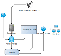
Training Course on Enterprise GIS Architecture Design and Implementation is meticulously designed to empower GIS professionals, IT architects, and spatial data managers with the cutting-edge knowledge and practical skills required to design, implement, and manage robust Enterprise GIS architectures.
Training Course on Enterprise GIS Architecture Design and Implementation is meticulously designed to empower GIS professionals, IT architects, and spatial data managers with the cutting-edge knowledge and practical skills required to design, implement, and manage robust Enterprise GIS architectures.
Training Course on Ethical Considerations in Geospatial Data Science addresses the critical need for Responsible Innovation within the geospatial domain, equipping professionals with the knowledge and tools to navigate these intricate challenges ethically.
Training Course on Ethical Considerations in Geospatial Data Science addresses the critical need for Responsible Innovation within the geospatial domain, equipping professionals with the knowledge and tools to navigate these intricate challenges ethically.
Training Course on Fundamentals of Geospatial Cloud Computing will equip participants with the foundational knowledge and practical skills required to navigate the rapidly evolving landscape of geospatial cloud platforms.
Training Course on Fundamentals of Geospatial Cloud Computing will equip participants with the foundational knowledge and practical skills required to navigate the rapidly evolving landscape of geospatial cloud platforms.
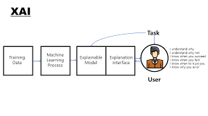
Training Course on Explainable AI (XAI) in Geospatial Decisions directly addresses this critical need by focusing on Explainable AI (XAI) techniques tailored for geospatial decision-making, empowering professionals to build, understand, and communicate transparent and trustworthy AI solutions in a spatial context.
Training Course on Explainable AI (XAI) in Geospatial Decisions directly addresses this critical need by focusing on Explainable AI (XAI) techniques tailored for geospatial decision-making, empowering professionals to build, understand, and communicate transparent and trustworthy AI solutions in a spatial context.
Training course on Exploratory Spatial Data Analysis (ESDA) is meticulously designed to bridge the gap between raw spatial data and actionable intelligence. Participants will delve into the core principles of ESDA, mastering the tools and methodologies required for effective spatial data exploration, pattern identification, and hypothesis generation
Training course on Exploratory Spatial Data Analysis (ESDA) is meticulously designed to bridge the gap between raw spatial data and actionable intelligence. Participants will delve into the core principles of ESDA, mastering the tools and methodologies required for effective spatial data exploration, pattern identification, and hypothesis generation
Training Course on Federated Learning in Geospatial Data Analysis offers an in-depth exploration of Federated Learning (FL) principles and their cutting-edge applications within Geospatial Data Analysis.
Training Course on Federated Learning in Geospatial Data Analysis offers an in-depth exploration of Federated Learning (FL) principles and their cutting-edge applications within Geospatial Data Analysis.
Training Course on Full-stack Web GIS Development with ArcGIS API for JavaScript is designed to equip participants with the in-demand skills needed to build robust, interactive, and data-driven geospatial web applications.
Training Course on Full-stack Web GIS Development with ArcGIS API for JavaScript is designed to equip participants with the in-demand skills needed to build robust, interactive, and data-driven geospatial web applications.
Training Course on Edge Computing for Geospatial Data Processing provides a deep dive into leveraging distributed processing capabilities closer to data sources, enabling real-time insights and optimized decision-making for critical spatial applications
Training Course on Edge Computing for Geospatial Data Processing provides a deep dive into leveraging distributed processing capabilities closer to data sources, enabling real-time insights and optimized decision-making for critical spatial applications
Training Course on GDAL/OGR Command-Line Tools Mastery offers an in-depth exploration of GDAL (Geospatial Data Abstraction Library) and OGR (OpenGIS Simple Features Reference Implementation) command-line utilities.
Training Course on GDAL/OGR Command-Line Tools Mastery offers an in-depth exploration of GDAL (Geospatial Data Abstraction Library) and OGR (OpenGIS Simple Features Reference Implementation) command-line utilities.
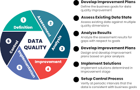
Training Course on Data Quality, Validation and Cleansing for Geospatial Data emphasizes practical data management techniques and best practices to ensure the integrity and fitness-for-use of all geospatial assets.
Training Course on Data Quality, Validation and Cleansing for Geospatial Data emphasizes practical data management techniques and best practices to ensure the integrity and fitness-for-use of all geospatial assets.