gis Courses
Comprehensive gis training programs for professionals
Comprehensive gis training programs for professionals

Geospatial Databases in the Cloud Training Course is meticulously designed to equip professionals with the skills to harness cloud computing for geospatial analytics.
Geospatial Databases in the Cloud Training Course is meticulously designed to equip professionals with the skills to harness cloud computing for geospatial analytics.
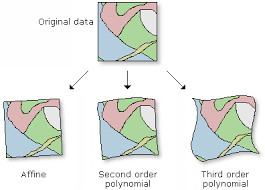
Training Course on Georeferencing and Spatial Alignment Techniques is designed to equip professionals with the essential skills to transform raw, unreferenced data into precise, actionable geographic information.
Training Course on Georeferencing and Spatial Alignment Techniques is designed to equip professionals with the essential skills to transform raw, unreferenced data into precise, actionable geographic information.
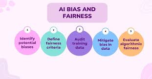
Training Course on Geospatial AI Ethics and Bias in Data is designed to equip professionals with the essential knowledge and tools to navigate the intricate landscape of GeoAI ethics. We will explore the various sources of bias in geospatial data and AI models, from data collection and algorithmic design to their societal impacts
Training Course on Geospatial AI Ethics and Bias in Data is designed to equip professionals with the essential knowledge and tools to navigate the intricate landscape of GeoAI ethics. We will explore the various sources of bias in geospatial data and AI models, from data collection and algorithmic design to their societal impacts
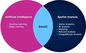
Training Course on Geospatial Artificial Intelligence (GeoAI) Fundamentals provides a comprehensive introduction to the rapidly evolving field where spatial science meets cutting-edge artificial intelligence.
Training Course on Geospatial Artificial Intelligence (GeoAI) Fundamentals provides a comprehensive introduction to the rapidly evolving field where spatial science meets cutting-edge artificial intelligence.
Training Course on Geospatial Backend Development with GeoDjango/Flask dives deep into Geospatial Backend Development, leveraging the robust capabilities of GeoDjango and the lightweight flexibility of Flask.
Training Course on Geospatial Backend Development with GeoDjango/Flask dives deep into Geospatial Backend Development, leveraging the robust capabilities of GeoDjango and the lightweight flexibility of Flask.
Training Course on Geospatial Big Data Streaming and Visualization is designed to equip professionals with the essential skills to harness the power of massive, real-time spatial datasets
Training Course on Geospatial Big Data Streaming and Visualization is designed to equip professionals with the essential skills to harness the power of massive, real-time spatial datasets
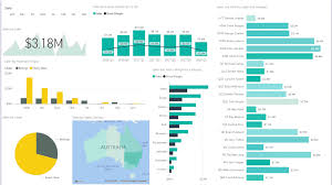
Training Course on Geospatial Business Intelligence (BI) Dashboard Development equips professionals with the essential skills to transform raw spatial and business data into powerful, interactive dashboards
Training Course on Geospatial Business Intelligence (BI) Dashboard Development equips professionals with the essential skills to transform raw spatial and business data into powerful, interactive dashboards
Training Course on Geospatial Consulting and Business Development is meticulously designed to equip professionals with the advanced knowledge and practical skills required to leverage geospatial data for impactful business decisions, market expansion, and operational efficiency.
Training Course on Geospatial Consulting and Business Development is meticulously designed to equip professionals with the advanced knowledge and practical skills required to leverage geospatial data for impactful business decisions, market expansion, and operational efficiency.
Training Course Geospatial Cybersecurity and Threat Intelligence addresses the urgent need for professionals to understand and mitigate the unique cyber risks associated with geospatial assets.
Training Course Geospatial Cybersecurity and Threat Intelligence addresses the urgent need for professionals to understand and mitigate the unique cyber risks associated with geospatial assets.
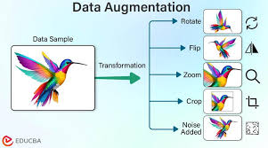
Training Course on Geospatial data augmentation for Deep Learning offers a comprehensive exploration of advanced geospatial data preprocessing, feature engineering, and augmentation strategies tailored for deep learning applications.
Training Course on Geospatial data augmentation for Deep Learning offers a comprehensive exploration of advanced geospatial data preprocessing, feature engineering, and augmentation strategies tailored for deep learning applications.
Training Course on Geospatial Data Curation and Archiving addresses the urgent need for professionals skilled in geospatial data curation and long-term archiving, ensuring data integrity, accessibility, and reusability across diverse sectors.
Training Course on Geospatial Data Curation and Archiving addresses the urgent need for professionals skilled in geospatial data curation and long-term archiving, ensuring data integrity, accessibility, and reusability across diverse sectors.
Training Course on GeoJSON and KML for Web Mapping Applications is meticulously designed to bridge the gap between raw spatial data and compelling web-based visualizations.
Training Course on GeoJSON and KML for Web Mapping Applications is meticulously designed to bridge the gap between raw spatial data and compelling web-based visualizations.