gis Courses
Comprehensive gis training programs for professionals
Comprehensive gis training programs for professionals
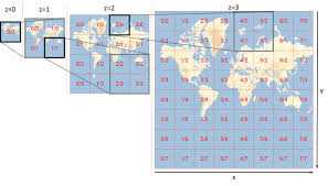
Web Mercator and Tiled Web Maps Optimization Training Course goes beyond theoretical concepts, focusing on practical implementation and performance tuning for real-world scenarios.
Web Mercator and Tiled Web Maps Optimization Training Course goes beyond theoretical concepts, focusing on practical implementation and performance tuning for real-world scenarios.
Web Scraping and Data Collection for Geospatial Projects Training Course is meticulously designed to empower professionals with the essential skills to automate data acquisition, transform unstructured web content into valuable spatial insights, and integrate diverse datasets for robust geospatial analysis
Web Scraping and Data Collection for Geospatial Projects Training Course is meticulously designed to empower professionals with the essential skills to automate data acquisition, transform unstructured web content into valuable spatial insights, and integrate diverse datasets for robust geospatial analysis
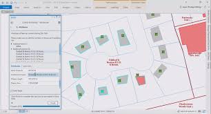
Workflow Automation in ArcGIS Pro Training Course delves into advanced workflow automation within ArcGIS Pro, empowering GIS professionals to significantly enhance efficiency and productivity.
Workflow Automation in ArcGIS Pro Training Course delves into advanced workflow automation within ArcGIS Pro, empowering GIS professionals to significantly enhance efficiency and productivity.
Workflow Automation in QGIS Training Course addresses the critical demand for GIS efficiency and data reproducibility
Workflow Automation in QGIS Training Course addresses the critical demand for GIS efficiency and data reproducibility
Spatial Machine Learning Training Course is designed to equip professionals with the practical skills needed to apply spatial machine learning techniques in various domains.
Spatial Machine Learning Training Course is designed to equip professionals with the practical skills needed to apply spatial machine learning techniques in various domains.
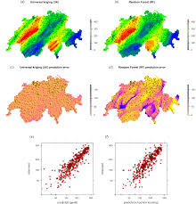
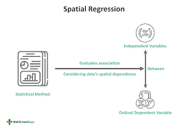
Spatial Statistics: Advanced Regression and Autocorrelation Training Course bridges this critical gap, equipping professionals with the cutting-edge analytical tools and methodologies necessary to uncover hidden spatial relationships, model complex geographic processes, and generate more accurate, actionable insights
Spatial Statistics: Advanced Regression and Autocorrelation Training Course bridges this critical gap, equipping professionals with the cutting-edge analytical tools and methodologies necessary to uncover hidden spatial relationships, model complex geographic processes, and generate more accurate, actionable insights
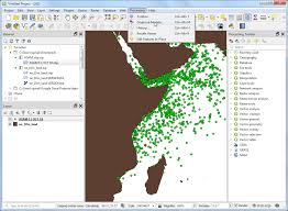
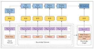
Spatio-Temporal Data Management in Open-Source Environments Training Course delves into the critical domain of Spatio-Temporal Data Management within accessible Open-Source Environments.
Spatio-Temporal Data Management in Open-Source Environments Training Course delves into the critical domain of Spatio-Temporal Data Management within accessible Open-Source Environments.
Synthetic Aperture Radar (SAR) Data Analysis Training Course provides participants with the foundational knowledge and practical skills required to effectively process, analyze, and interpret SAR data, transforming raw signals into actionable geospatial intelligence.
Synthetic Aperture Radar (SAR) Data Analysis Training Course provides participants with the foundational knowledge and practical skills required to effectively process, analyze, and interpret SAR data, transforming raw signals into actionable geospatial intelligence.
Technical Writing for GIS Documentation Training Course empowers geospatial professionals, GIS analysts, and technical communicators to master the art of creating clear, concise, and user-friendly documentation that bridges the gap between intricate technical details and diverse user needs
Technical Writing for GIS Documentation Training Course empowers geospatial professionals, GIS analysts, and technical communicators to master the art of creating clear, concise, and user-friendly documentation that bridges the gap between intricate technical details and diverse user needs
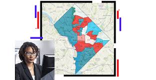
Geographic Information Systems (GIS) for Crime Analysis and Law Enforcement Training Course provides law enforcement professionals and crime analysts with the essential skills to leverage Geographic Information Systems (GIS) for advanced crime analysis, predictive policing, and strategic resource allocation.
Geographic Information Systems (GIS) for Crime Analysis and Law Enforcement Training Course provides law enforcement professionals and crime analysts with the essential skills to leverage Geographic Information Systems (GIS) for advanced crime analysis, predictive policing, and strategic resource allocation.
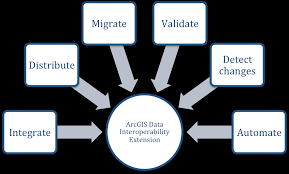
GIS for Data Integration and Interoperability Training Course is designed to equip professionals with the cutting-edge knowledge and practical skills required to achieve robust GIS data integration and foster genuine interoperability, ensuring that spatial information flows freely and contributes to enhanced insights and operational efficiency.
GIS for Data Integration and Interoperability Training Course is designed to equip professionals with the cutting-edge knowledge and practical skills required to achieve robust GIS data integration and foster genuine interoperability, ensuring that spatial information flows freely and contributes to enhanced insights and operational efficiency.
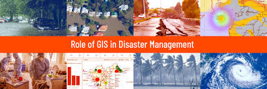
Geographic Information Systems for Disaster Management and Emergency Response Training Course empowers professionals with sophisticated Geospatial Intelligence and Spatial Analytics skills crucial for Disaster Risk Reduction (DRR) and Emergency Preparedness.
Geographic Information Systems for Disaster Management and Emergency Response Training Course empowers professionals with sophisticated Geospatial Intelligence and Spatial Analytics skills crucial for Disaster Risk Reduction (DRR) and Emergency Preparedness.