gis Courses
Comprehensive gis training programs for professionals
Comprehensive gis training programs for professionals
Training Course on GIS for Insurance and Risk Assessment provides a comprehensive geospatial intelligence framework for professionals in the insurance sector and risk management.
Training Course on GIS for Insurance and Risk Assessment provides a comprehensive geospatial intelligence framework for professionals in the insurance sector and risk management.
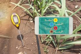
Training Course on Geographic Information Systems for Natural Resource Management and Conservation
Training Course on Geographic Information Systems for Natural Resource Management and Conservation
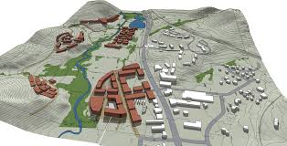
Training Course on 3D GIS Modeling and Visualization is meticulously designed to transform your understanding of spatial data from a flat, two-dimensional plane into dynamic, realistic, and highly impactful 3D environments.
Training Course on 3D GIS Modeling and Visualization is meticulously designed to transform your understanding of spatial data from a flat, two-dimensional plane into dynamic, realistic, and highly impactful 3D environments.
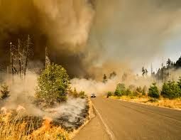
Training Course on Geographic Information Systems for Forestry and Wildfire Management offers a critical foundation for professionals navigating the complexities of modern environmental challenges.
Training Course on Geographic Information Systems for Forestry and Wildfire Management offers a critical foundation for professionals navigating the complexities of modern environmental challenges.
Training Course on GIS for Geotechnical Engineering bridges the gap between traditional geotechnical practices and cutting-edge geospatial technologies, empowering engineers to make more informed and efficient decisions.
Training Course on GIS for Geotechnical Engineering bridges the gap between traditional geotechnical practices and cutting-edge geospatial technologies, empowering engineers to make more informed and efficient decisions.
Training Course on GIS for Green Infrastructure Planning provides a robust foundation in leveraging Geographic Information Systems (GIS) for the strategic planning, design, and management of Green Infrastructure (GI).
Training Course on GIS for Green Infrastructure Planning provides a robust foundation in leveraging Geographic Information Systems (GIS) for the strategic planning, design, and management of Green Infrastructure (GI).
Training Course on GIS for Humanitarian Aid and Development equips professionals with advanced geospatial skills to tackle pressing global challenges, from disaster response and refugee management to public health interventions and climate adaptation.
Training Course on GIS for Humanitarian Aid and Development equips professionals with advanced geospatial skills to tackle pressing global challenges, from disaster response and refugee management to public health interventions and climate adaptation.
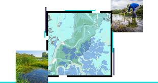
Training Course on GIS for Hydrology and Water Resource Management is designed to bridge the gap between theoretical understanding and practical application, equipping participants with the skills to tackle complex water challenges.
Training Course on GIS for Hydrology and Water Resource Management is designed to bridge the gap between theoretical understanding and practical application, equipping participants with the skills to tackle complex water challenges.
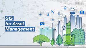
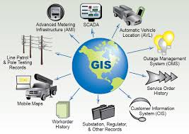
Training Course on GIS for Infrastructure Asset Management delves into the critical intersection of GIS and Infrastructure Asset Management, equipping professionals with the essential skills to leverage powerful geospatial tools for the entire asset lifecycle, from planning and design to maintenance and rehabilitation
Training Course on GIS for Infrastructure Asset Management delves into the critical intersection of GIS and Infrastructure Asset Management, equipping professionals with the essential skills to leverage powerful geospatial tools for the entire asset lifecycle, from planning and design to maintenance and rehabilitation
Training Course on Geographic Information Systems for Land Administration and Cadastral Mapping is designed to empower land professionals with cutting-edge GIS competencies, enabling them to navigate the complexities of contemporary land challenges.
Training Course on Geographic Information Systems for Land Administration and Cadastral Mapping is designed to empower land professionals with cutting-edge GIS competencies, enabling them to navigate the complexities of contemporary land challenges.
Training Course on GIS for Maritime and Oceanographic Mapping is meticulously designed to equip participants with the essential geospatial skills required to effectively manage, analyze, and visualize complex marine data.
Training Course on GIS for Maritime and Oceanographic Mapping is meticulously designed to equip participants with the essential geospatial skills required to effectively manage, analyze, and visualize complex marine data.
Training Course on AI-Powered Image Processing for Geospatial Data delves into the transformative world of AI-powered image processing for geospatial data. Participants will gain expertise in leveraging cutting-edge Artificial Intelligence (AI) and Machine Learning (ML) techniques to extract valuable insights from various geospatial imagery sources, including satellite imagery, aerial photography, and drone data.
Training Course on AI-Powered Image Processing for Geospatial Data delves into the transformative world of AI-powered image processing for geospatial data. Participants will gain expertise in leveraging cutting-edge Artificial Intelligence (AI) and Machine Learning (ML) techniques to extract valuable insights from various geospatial imagery sources, including satellite imagery, aerial photography, and drone data.