gis Courses
Comprehensive gis training programs for professionals
Comprehensive gis training programs for professionals

Google Earth Engine for Large-Scale Geospatial Analysis Training Course provides a comprehensive introduction to Google Earth Engine (GEE), a powerful, cloud-based platform for planetary-scale geospatial analysis.
Google Earth Engine for Large-Scale Geospatial Analysis Training Course provides a comprehensive introduction to Google Earth Engine (GEE), a powerful, cloud-based platform for planetary-scale geospatial analysis.
Grant Writing and Proposal Development for GIS Projects Training Course is designed to empower individuals and organizations to effectively articulate the value and impact of their GIS initiatives.
Grant Writing and Proposal Development for GIS Projects Training Course is designed to empower individuals and organizations to effectively articulate the value and impact of their GIS initiatives.

GraphQL for Geospatial APIs Training Course is meticulously designed to equip developers, GIS professionals, and data architects with the essential skills to leverage GraphQL's powerful query capabilities for modern geospatial data management and API development.
GraphQL for Geospatial APIs Training Course is meticulously designed to equip developers, GIS professionals, and data architects with the essential skills to leverage GraphQL's powerful query capabilities for modern geospatial data management and API development.
High-Resolution Satellite Imagery Applications Training Course is designed to empower professionals with cutting-edge techniques for leveraging HRSI.
High-Resolution Satellite Imagery Applications Training Course is designed to empower professionals with cutting-edge techniques for leveraging HRSI.
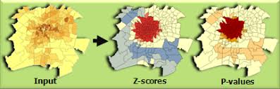
Hotspot Analysis and Clustering for Spatial Patterns Training Course equips professionals with advanced spatial analytical skills to identify, interpret, and leverage hotspots and spatial clusters in diverse datasets.
Hotspot Analysis and Clustering for Spatial Patterns Training Course equips professionals with advanced spatial analytical skills to identify, interpret, and leverage hotspots and spatial clusters in diverse datasets.
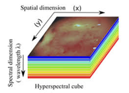
Training Course on Advanced Hyperspectral and Multispectral Image Analysis is meticulously designed to equip professionals with the theoretical foundations and practical skills necessary to effectively process, analyze, and interpret HSI and MSI data.
Training Course on Advanced Hyperspectral and Multispectral Image Analysis is meticulously designed to equip professionals with the theoretical foundations and practical skills necessary to effectively process, analyze, and interpret HSI and MSI data.
Training Course on GIS for Urban Mobility and Traffic Analysis is designed to equip professionals with the essential skills to leverage cutting-edge geospatial technologies for optimizing urban mobility, enhancing traffic flow, and fostering sustainable urban development.
Training Course on GIS for Urban Mobility and Traffic Analysis is designed to equip professionals with the essential skills to leverage cutting-edge geospatial technologies for optimizing urban mobility, enhancing traffic flow, and fostering sustainable urban development.
Training Course on GIS for Transportation Planning and Logistics will equip participants with the skills to harness cutting-edge GIS tools and techniques.
Training Course on GIS for Transportation Planning and Logistics will equip participants with the skills to harness cutting-edge GIS tools and techniques.
Training Course on GIS for Tourism and Recreation Planning is meticulously designed to equip professionals with the foundational knowledge and practical skills to harness the power of GIS technology
Training Course on GIS for Tourism and Recreation Planning is meticulously designed to equip professionals with the foundational knowledge and practical skills to harness the power of GIS technology
Training Course on Geographic Information Systems (GIS) for Telecommunications Network Planning is meticulously designed to provide a comprehensive understanding of how geospatial data, network modeling, and spatial analysis can address complex challenges in the telecommunications sector.
Training Course on Geographic Information Systems (GIS) for Telecommunications Network Planning is meticulously designed to provide a comprehensive understanding of how geospatial data, network modeling, and spatial analysis can address complex challenges in the telecommunications sector.
Training Course on GIS for Sustainable Development Goals (SDGs) Monitoring delves into the practical application of geospatial data and tools for SDG localization and tracking
Training Course on GIS for Sustainable Development Goals (SDGs) Monitoring delves into the practical application of geospatial data and tools for SDG localization and tracking
Training Course on GIS for Supply Chain Optimization equips professionals with the essential knowledge and practical skills to leverage geospatial intelligence for enhanced operational efficiency, cost reduction, and building resilient supply networks
Training Course on GIS for Supply Chain Optimization equips professionals with the essential knowledge and practical skills to leverage geospatial intelligence for enhanced operational efficiency, cost reduction, and building resilient supply networks