gis Courses
Comprehensive gis training programs for professionals
Comprehensive gis training programs for professionals
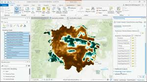
Training Course on Machine Learning for Geospatial Data Classification provides a comprehensive deep dive into the powerful intersection of Machine Learning (ML) and Geospatial Data
Training Course on Machine Learning for Geospatial Data Classification provides a comprehensive deep dive into the powerful intersection of Machine Learning (ML) and Geospatial Data
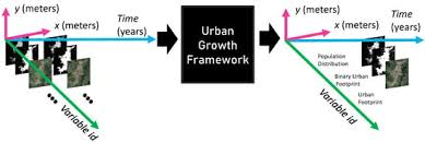
Training Course on Machine Learning for Urban Growth Modeling provides a comprehensive exploration of how ML can be applied to urban growth modeling.
Training Course on Machine Learning for Urban Growth Modeling provides a comprehensive exploration of how ML can be applied to urban growth modeling.
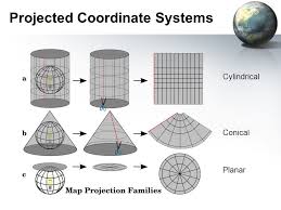
Training Course on Mastering Geodesy, Projections, and Coordinate Systems is meticulously designed to equip geospatial professionals, engineers, and scientists with
Training Course on Mastering Geodesy, Projections, and Coordinate Systems is meticulously designed to equip geospatial professionals, engineers, and scientists with
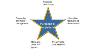
Training Course on Metadata Management and Geospatial Data Standards emphasizes how comprehensive metadata empowers organizations to build reliable Spatial Data Infrastructures (SDIs), fostering data interoperability, reducing duplication, and enhancing overall data governance
Training Course on Metadata Management and Geospatial Data Standards emphasizes how comprehensive metadata empowers organizations to build reliable Spatial Data Infrastructures (SDIs), fostering data interoperability, reducing duplication, and enhancing overall data governance
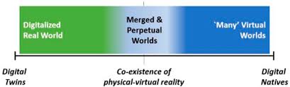
Training Course on Metaverse and Spatial Computing for GIS Professionals is specifically designed to equip GIS professionals with the advanced skills needed to navigate and contribute to the immersive web.
Training Course on Metaverse and Spatial Computing for GIS Professionals is specifically designed to equip GIS professionals with the advanced skills needed to navigate and contribute to the immersive web.
Training Course Mobile GIS App Development dives deep into the dynamic world of Mobile GIS App Development, equipping participants with the cutting-edge skills to design, build, and deploy robust geospatial applications for various mobile platforms.
Training Course Mobile GIS App Development dives deep into the dynamic world of Mobile GIS App Development, equipping participants with the cutting-edge skills to design, build, and deploy robust geospatial applications for various mobile platforms.
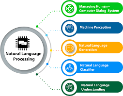
Training Course on Natural Language Processing (NLP) for Geospatial Text Data focuses on practical, hands-on application of cutting-edge NLP techniques tailored for geospatial analysis. Participants will gain expertise in information extraction, named entity recognition (NER), geocoding, sentiment analysis, and topic modeling within a spatial context.
Training Course on Natural Language Processing (NLP) for Geospatial Text Data focuses on practical, hands-on application of cutting-edge NLP techniques tailored for geospatial analysis. Participants will gain expertise in information extraction, named entity recognition (NER), geocoding, sentiment analysis, and topic modeling within a spatial context.
Training Course on Network Analysis and Optimization in GIS is meticulously designed to equip professionals with the essential geospatial skills to leverage spatial data for enhanced operational efficiency and strategic planning
Training Course on Network Analysis and Optimization in GIS is meticulously designed to equip professionals with the essential geospatial skills to leverage spatial data for enhanced operational efficiency and strategic planning
Training Course on Object Detection in Aerial and Satellite Imagery provides a comprehensive dive into Object Detection in Aerial and Satellite Imagery, leveraging cutting-edge Deep Learning frameworks like YOLO and Faster R-CNN
Training Course on Object Detection in Aerial and Satellite Imagery provides a comprehensive dive into Object Detection in Aerial and Satellite Imagery, leveraging cutting-edge Deep Learning frameworks like YOLO and Faster R-CNN
Training Course on Open-Source Geospatial Libraries in Python (Fiona, Rasterio) empowers participants with the essential skills to proficiently handle and analyze geospatial data using industry-standard open-source Python libraries, specifically Fiona and Rasterio.
Training Course on Open-Source Geospatial Libraries in Python (Fiona, Rasterio) empowers participants with the essential skills to proficiently handle and analyze geospatial data using industry-standard open-source Python libraries, specifically Fiona and Rasterio.
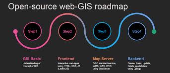
Training Course on Open-Source Web GIS Development the growing need for skilled professionals who can harness the power of open-source technologies to create innovative geospatial web applications.
Training Course on Open-Source Web GIS Development the growing need for skilled professionals who can harness the power of open-source technologies to create innovative geospatial web applications.
Training course on Passive and Active Remote Sensing Principles delves into the fundamental principles of remote sensing, equipping participants with the knowledge and practical skills to harness both passive and active remote sensing technologies for diverse applications.
Training course on Passive and Active Remote Sensing Principles delves into the fundamental principles of remote sensing, equipping participants with the knowledge and practical skills to harness both passive and active remote sensing technologies for diverse applications.