gis Courses
Comprehensive gis training programs for professionals
Comprehensive gis training programs for professionals
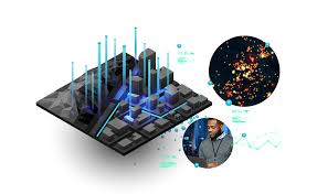
GIS Data Integration Training Course equips professionals with the technical expertise to merge spatial and non-spatial datasets, implement automated workflows, and apply geospatial intelligence for diverse applications such as urban planning, environmental monitoring, and infrastructure development.
GIS Data Integration Training Course equips professionals with the technical expertise to merge spatial and non-spatial datasets, implement automated workflows, and apply geospatial intelligence for diverse applications such as urban planning, environmental monitoring, and infrastructure development.
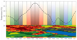
Thermal Remote Sensing & Heat Island Analysis Training Course provides a comprehensive understanding of Thermal Remote Sensing principles and their application in Urban Heat Island (UHI) analysis.
Thermal Remote Sensing & Heat Island Analysis Training Course provides a comprehensive understanding of Thermal Remote Sensing principles and their application in Urban Heat Island (UHI) analysis.
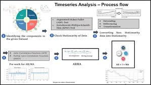
This program emphasizes a hands-on learning approach, leveraging cutting-edge GIS software and Time-Series Analysis of Geospatial Data Training Course programming tools to analyze real-world satellite imagery, sensor data, and other geolocated time-series data.
This program emphasizes a hands-on learning approach, leveraging cutting-edge GIS software and Time-Series Analysis of Geospatial Data Training Course programming tools to analyze real-world satellite imagery, sensor data, and other geolocated time-series data.
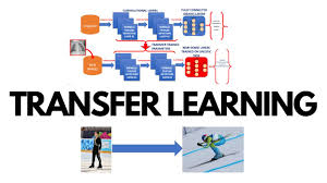
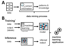
Transfer Learning in Geospatial Deep Learning Training Course emphasizes practical implementation and real-world problem-solving in areas such as environmental monitoring, urban planning, disaster management, and resource optimization.
Transfer Learning in Geospatial Deep Learning Training Course emphasizes practical implementation and real-world problem-solving in areas such as environmental monitoring, urban planning, disaster management, and resource optimization.
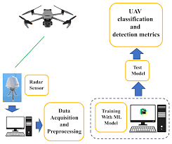
UAV-Based Lidar Systems and Data Fusion Training Course offers an immersive experience into the cutting-edge world of UAV-based LiDAR systems and data fusion techniques
UAV-Based Lidar Systems and Data Fusion Training Course offers an immersive experience into the cutting-edge world of UAV-based LiDAR systems and data fusion techniques
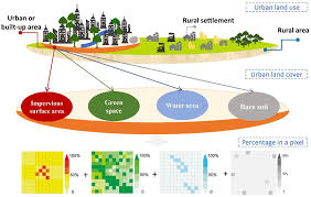
Urban Remote Sensing and Impervious Surface Mapping Training Course provides a comprehensive deep dive into Urban Remote Sensing and Impervious Surface Mapping, critical disciplines for sustainable urban development and environmental management
Urban Remote Sensing and Impervious Surface Mapping Training Course provides a comprehensive deep dive into Urban Remote Sensing and Impervious Surface Mapping, critical disciplines for sustainable urban development and environmental management
User Experience (UX) Design for Geospatial Web Applications Training Course delves into the critical role of User Experience (UX) design in creating intuitive, effective, and engaging geospatial web applications.
User Experience (UX) Design for Geospatial Web Applications Training Course delves into the critical role of User Experience (UX) design in creating intuitive, effective, and engaging geospatial web applications.
Vector Data Editing and Quality Control Best Practices Training Course provides GIS professionals and data stewards with the essential knowledge and practical skills required for meticulous vector data editing and the implementation of robust quality control protocols.
Vector Data Editing and Quality Control Best Practices Training Course provides GIS professionals and data stewards with the essential knowledge and practical skills required for meticulous vector data editing and the implementation of robust quality control protocols.
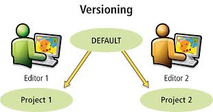
Versioning and Multi-User Geodatabase Management Training Course delves into the critical concepts of versioning and multi-user geodatabase environments, providing participants with the advanced skills necessary to maintain data integrity, facilitate collaborative editing, and optimize performance in complex GIS operations.
Versioning and Multi-User Geodatabase Management Training Course delves into the critical concepts of versioning and multi-user geodatabase environments, providing participants with the advanced skills necessary to maintain data integrity, facilitate collaborative editing, and optimize performance in complex GIS operations.
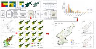
Time-Series Remote Sensing for Land Use/Cover Change Training Course provides a comprehensive dive into Time-Series Remote Sensing for analyzing Land Use/Cover Change (LULCC), equipping participants with cutting-edge skills to monitor and understand dynamic landscape transformations.
Time-Series Remote Sensing for Land Use/Cover Change Training Course provides a comprehensive dive into Time-Series Remote Sensing for analyzing Land Use/Cover Change (LULCC), equipping participants with cutting-edge skills to monitor and understand dynamic landscape transformations.
Virtual Reality (VR) and Augmented Reality (AR) for Geographic Information Systems (GIS) Training Course delves into the fundamental principles and emerging trends of VR and AR integration with GIS, covering everything from 3D modeling and spatial data integration to immersive experience design and application development.
Virtual Reality (VR) and Augmented Reality (AR) for Geographic Information Systems (GIS) Training Course delves into the fundamental principles and emerging trends of VR and AR integration with GIS, covering everything from 3D modeling and spatial data integration to immersive experience design and application development.
Volumetric Analysis in 3D GIS Training Course provides a comprehensive deep dive into Volumetric Analysis within 3D GIS environments, equipping professionals with advanced geospatial skills to tackle complex real-world challenges.
Volumetric Analysis in 3D GIS Training Course provides a comprehensive deep dive into Volumetric Analysis within 3D GIS environments, equipping professionals with advanced geospatial skills to tackle complex real-world challenges.