Using Drones for Wildlife Census Training Course
Using Drones for Wildlife Census Training Course is designed to provide comprehensive, hands-on training to equip participants with the essential skills and knowledge required to deploy drones for effective and ethical wildlife census operations.
Course Overview
Using Drones for Wildlife Census Training Course
Introduction
The rapidly advancing field of conservation technology is being revolutionized by the use of unmanned aerial vehicles (UAVs), commonly known as drones. This innovative approach to wildlife management is transforming traditional methods of ecological research and data collection, offering unprecedented access to remote and difficult-to-survey areas. By leveraging cutting-edge drone technology, conservationists, researchers, and government agencies can conduct precise and efficient wildlife censuses, track population dynamics, and monitor habitats with minimal disturbance. Using Drones for Wildlife Census Training Course is designed to provide comprehensive, hands-on training to equip participants with the essential skills and knowledge required to deploy drones for effective and ethical wildlife census operations.
Our program goes beyond basic flight skills to focus on the specialized applications of drones in ecological monitoring. Participants will learn how to integrate advanced sensors like thermal and multispectral cameras with AI-powered data analytics to generate high-fidelity, georeferenced data. The curriculum is built on a foundation of real-world case studies, ensuring that learners are prepared to tackle complex challenges such as anti-poaching surveillance, habitat mapping, and biodiversity assessment. This course is an invaluable opportunity for professionals to gain a competitive edge in the burgeoning field of conservation technology, enabling them to contribute to sustainable conservation strategies and protect global biodiversity.
Course Outline
10 days
Course Objectives
Upon completion of this course, participants will be able to:
- Master advanced drone flight operations for wildlife census missions.
- Apply current regulations and ethical frameworks for drone use in sensitive ecological areas.
- Utilize thermal imaging and multispectral sensors for accurate species detection and habitat health analysis.
- Process and analyze aerial imagery and data using advanced GIS and AI-powered software.
- Conduct comprehensive population counts and behavioral studies with minimal wildlife disturbance.
- Develop strategic anti-poaching and surveillance plans using real-time drone data.
- Create high-resolution orthomosaic maps for habitat mapping and land management.
- Integrate drone data with existing Geographic Information Systems (GIS) for spatial analysis.
- Implement predictive analytics and machine learning models for proactive conservation.
- Design and execute effective drone-based environmental monitoring and research projects.
- Perform pre-flight inspections, maintenance, and troubleshooting for specialized drone payloads.
- Respond effectively to wildlife emergencies and natural disasters using rapid drone deployment.
- Communicate and report findings to stakeholders and policymakers using data-driven insights.
Organizational Benefits
- Significantly reduce the time, labor, and costs associated with traditional ground and manned-aircraft surveys.
- Collect high-resolution, georeferenced data with superior precision, leading to more reliable scientific and conservation outcomes.
- Minimize risks to field personnel by conducting surveys and surveillance in hazardous or remote environments from a safe distance.
- Leverage real-time data and predictive analytics to anticipate and mitigate threats like poaching and habitat fragmentation.
- Build internal expertise in a high-growth field, enabling organizations to lead innovative, technology-driven conservation efforts.
- Ensure operations comply with international regulations and best practices, enhancing an organization's reputation and credibility.
- Provide leadership with robust, evidence-based insights to inform sustainable resource management and policy development.
Target Audience
- Wildlife Conservation Officers and Managers
- Environmental Scientists and Ecologists
- National Park Rangers and Forest Management Professionals
- NGO Staff in Wildlife Protection and Development
- Research Scholars and Graduate Students in Ecology and Environmental Science
- Drone Technicians and Pilots specializing in aerial data collection
- Policymakers and Government Officials involved in environmental policy
- Agricultural and Land-Use Planners with a focus on sustainable practices
Course Modules
Module 1: Foundations of Conservation Drones
- Evolution and history of UAVs in wildlife research and management.
- Types of drones (multi-rotor, fixed-wing) and their applications in different ecosystems.
- Key drone components, payloads, and sensor technology for ecological data collection.
- Flight dynamics, mission planning software, and navigation systems.
- Case Study: Analyzing the transition from manned aircraft to drones for wildlife surveys in the African savanna.
Module 2: Regulations, Safety, and Ethics
- Global and national drone regulations for commercial and recreational use.
- Aeronautical knowledge, airspace classification, and flight authorizations.
- Safety protocols, risk assessment, and emergency procedures for remote operations.
- Ethical considerations for wildlife monitoring to minimize disturbance and ensure animal welfare.
- Case Study: The legal and ethical challenges of using drones for anti-poaching in South Asia.
Module 3: Aerial Imaging and Data Acquisition
- Principles of high-resolution RGB, thermal, and multispectral imaging.
- Best practices for capturing georeferenced aerial photography and video.
- Data storage, transfer, and management in the field and post-mission.
- Sensor calibration and optimization for specific wildlife and habitat types.
- Case Study: Using thermal cameras to conduct a nocturnal census of endangered nocturnal species.
Module 4: GIS and Spatial Analysis
- Introduction to Geographic Information Systems (GIS) for conservation.
- Processing drone imagery to create orthomosaic maps and digital surface models.
- Integrating drone data with existing GIS databases for spatial analysis.
- Mapping and monitoring habitat changes, including deforestation and land degradation.
- Case Study: Mapping illegal logging corridors in the Amazon rainforest using drone-generated GIS data.
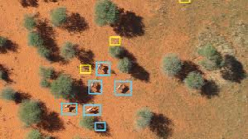
Module 5: Wildlife Population Census Techniques
- Scientific methodology for conducting population counts using drones.
- Advanced techniques for object detection and individual animal identification.
- Statistical analysis of drone-collected data for population estimation.
- Comparing drone census accuracy with traditional ground-based survey methods.
- Case Study: Conducting a successful drone-based aerial census of marine mammals in a coastal conservation area.
Module 6: AI and Machine Learning for Conservation
- Fundamentals of AI and machine learning for automated species recognition.
- Training custom AI models to identify and count specific wildlife.
- Implementing predictive analytics to forecast population movements and threats.
- Real-time data processing and anomaly detection for immediate intervention.
- Case Study: Deploying an AI-powered system to automatically identify and flag instances of human-wildlife conflict.
Module 7: Anti-Poaching and Surveillance
- Designing strategic drone patrol routes for protected areas and wildlife corridors.
- Utilizing live-streaming and night vision capabilities for real-time surveillance.
- Command and control center operations for coordinating drone teams with ground patrols.
- Leveraging thermal drones to detect and track poachers in low-light conditions.
- Case Study: Implementing a multi-drone surveillance system to reduce poaching incidents in a national park.
Module 8: Habitat and Ecosystem Mapping
- Advanced mapping techniques for large-scale habitat assessment.
- Analyzing vegetation health and biomass using multispectral data (NDVI, etc.).
- Monitoring ecological restoration projects and assessing their progress.
- Detecting invasive species and mapping their spread.
- Case Study: Using drone-based multispectral analysis to monitor the health of a coral reef ecosystem.
Module 9: Marine and Coastal Monitoring
- Adapting drone operations for coastal and marine environments.
- Techniques for counting marine megafauna (whales, dolphins, seals) from the air.
- Monitoring coastal erosion, pollution, and illegal fishing activities.
- Utilizing underwater drones to assess coral reefs and marine biodiversity.
- Case Study: A collaborative effort to track and protect sea turtle nesting sites along a coastline.
Module 10: Drones in Disaster and Emergency Response
- Rapid deployment of drones for post-disaster habitat assessment (wildfires, floods).
- Search and rescue operations for injured or stranded wildlife.
- Utilizing drones to deliver essential supplies or medical payloads to remote animals.
- Coordinating with emergency services for a unified response.
- Case Study: The role of drones in assessing habitat damage and locating surviving wildlife after the Australian bushfires.
Module 11: Project Planning and Management
- Developing a comprehensive drone-based conservation project plan.
- Budgeting, resource allocation, and team management for a drone unit.
- Defining project goals, outcomes, and key performance indicators (KPIs).
- Data-driven reporting and communication with stakeholders and funding agencies.
- Case Study: Designing a long-term drone program for a non-governmental organization focused on elephant conservation.
Module 12: Drone Maintenance and Troubleshooting
- Routine pre-flight and post-flight maintenance procedures.
- Common flight issues and on-site troubleshooting techniques.
- Battery management, firmware updates, and software upgrades.
- Building and repairing custom drones for specific environmental challenges.
- Case Study: A simulated troubleshooting scenario to address a common technical issue during a critical mission.
Module 13: The Future of Drones in Conservation
- Emerging technologies: autonomous swarms, long-range BVLOS (Beyond Visual Line of Sight) operations.
- Integration of drones with other technologies (IoT, satellite imagery).
- The role of open-source platforms and citizen science in scaling up conservation efforts.
- Forecasting future trends in conservation technology and policy.
- Case Study: Exploring the potential of autonomous drones for long-term, continuous monitoring in a large protected area.
Training Methodology
This course utilizes a blended learning approach, combining theoretical knowledge with extensive practical, hands-on training.
- Expert-Led Lectures.
- Hands-On Flight Practicum.
- Case Study Analysis.
- Group Projects and Simulations.
- Software Workshops.
- Field Assessments.
Register as a group from 3 participants for a Discount
Send us an email: [email protected] or call +254724527104
Certification
Upon successful completion of this training, participants will be issued with a globally- recognized certificate.
Tailor-Made Course
We also offer tailor-made courses based on your needs.
Key Notes
a. The participant must be conversant with English.
b. Upon completion of training the participant will be issued with an Authorized Training Certificate
c. Course duration is flexible and the contents can be modified to fit any number of days.
d. The course fee includes facilitation training materials, 2 coffee breaks, buffet lunch and A Certificate upon successful completion of Training.
e. One-year post-training support Consultation and Coaching provided after the course.
f. Payment should be done at least a week before commence of the training, to DATASTAT CONSULTANCY LTD account, as indicated in the invoice so as to enable us prepare better for you.