Training course on Web GIS Development for Infrastructure Portals
Training Course on Web GIS Development for Infrastructure Portals is meticulously designed to provide participants with the practical skills required for designing, developing, and deploying robust Web GIS infrastructure portals
Course Overview
Training Course on Web GIS Development for Infrastructure Portals
Introduction
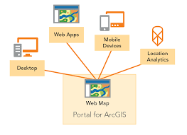
The rapid evolution of modern infrastructure projects has led to an escalating demand for accessible, interactive, and centralized platforms capable of managing and visualizing vast amounts of geospatial and asset-specific data. Traditional desktop GIS applications, while powerful, often fall short in enabling widespread collaboration, real-time data sharing, and user-friendly access for a diverse range of stakeholders. Web GIS, by seamlessly leveraging internet technologies and advanced geospatial capabilities, offers a transformative solution to bridge this critical gap. It empowers the creation of dynamic infrastructure portals that provide intuitive access to interactive maps, essential data, powerful analytics, and critical operational insights, serving decision-makers, engineers, dedicated field crews, and the general public alike.
Training Course on Web GIS Development for Infrastructure Portals is meticulously designed to provide participants with the practical skills required for designing, developing, and deploying robust Web GIS infrastructure portals. The curriculum will cover foundational Web GIS concepts, explore various cutting-edge development frameworks and APIs (e.g., ArcGIS API for JavaScript, Leaflet, OpenLayers), and delve into mastering secure database integration for complex spatial data. Key areas of focus include implementing secure data access with robust user authentication, and incorporating advanced features such as real-time data feeds, sophisticated analytical tools, and intuitive interactive dashboards. Through a balanced blend of essential theoretical foundations and extensive hands-on coding exercises, culminating in project-based learning, this course will comprehensively prepare participants to build and effectively manage sophisticated Web GIS solutions for modern infrastructure asset management and strategic planning.
Course Objectives
Upon completion of this course, participants will be able to:
- Analyze the fundamental concepts of Web GIS and its pivotal role in infrastructure data visualization and management.
- Comprehend the principles of web mapping services, spatial databases, and data publishing for infrastructure portals.
- Master various Web GIS development frameworks, libraries (e.g., Leaflet, OpenLayers), and APIs (e.g., ArcGIS API for JavaScript).
- Develop expertise in designing intuitive user interfaces (UI) and user experiences (UX) for infrastructure portals.
- Formulate strategies for integrating diverse infrastructure data sources (BIM, IoT, CAD, enterprise data) into Web GIS.
- Understand the critical role of secure data access, user authentication, and authorization in portal development.
- Implement robust approaches to real-time data visualization and streaming from IoT sensors in infrastructure.
- Explore key strategies for incorporating analytical tools, querying capabilities, and custom widgets into portals.
- Apply methodologies for optimizing web map performance, scalability, and responsiveness for large datasets.
- Understand the importance of version control, testing, and deployment strategies for Web GIS applications.
- Develop preliminary skills in utilizing server-side programming (e.g., Python, Node.js) for data processing and APIs.
- Design and develop a functional Web GIS infrastructure portal prototype based on a real-world scenario.
- Examine global best practices and future trends in Web GIS, digital twins, and smart infrastructure visualization.
Target Audience
This course is ideal for professionals involved in geospatial data, web development, and infrastructure management:
- GIS Professionals: Seeking to expand skills into web development and portal creation.
- Web Developers: Interested in applying web development skills to geospatial data and infrastructure.
- Civil Engineers & Planners: Needing to visualize and share project data through interactive maps.
- Infrastructure Asset Managers: Looking for web-based tools to monitor and manage assets.
- IT Professionals in AEC/Utilities: Supporting geospatial data infrastructure and web applications.
- Data Scientists & Analysts: Visualizing and interacting with spatial data in web browsers.
- Urban Developers & Researchers: Building interactive platforms for smart city initiatives.
- Project Managers: Requiring accessible, centralized data visualization and collaboration tools.
Course Duration: 10 Days
Course Modules
- Module 1: Introduction to Web GIS for Infrastructure
- Define Web GIS and its evolution from desktop GIS.
- Discuss the unique requirements of infrastructure data visualization and management.
- Understand the benefits of web-based portals for collaboration and public engagement.
- Explore key components of a Web GIS architecture (client, server, data).
- Identify common use cases for Web GIS in civil engineering and infrastructure.
- Module 2: Web Mapping Fundamentals and Standards
- Comprehend the principles of web mapping services (WMS, WMTS, WFS, ArcGIS REST API).
- Learn about common geospatial data formats for the web (GeoJSON, KML, TopoJSON).
- Master techniques for projecting and transforming spatial data for web display.
- Discuss the role of basemaps and tile services in web mapping applications.
- Explore open standards for geospatial web services and data interoperability.
- Module 3: Introduction to Frontend Web Development (HTML, CSS, JavaScript)
- Develop expertise in foundational web development languages: HTML for structure.
- Learn about CSS for styling and layout of web applications.
- Master JavaScript for interactive elements and dynamic content.
- Discuss the Document Object Model (DOM) and event handling.
- Explore basic concepts of responsive web design for different devices.
- Module 4: Web GIS JavaScript Libraries: Leaflet and OpenLayers
- Formulate strategies for building interactive maps using Leaflet.js.
- Understand the core features and extensibility of Leaflet for web mapping.
- Explore techniques for working with OpenLayers for advanced geospatial applications.
- Discuss the strengths and weaknesses of Leaflet vs. OpenLayers for infrastructure portals.
- Apply practical exercises to create basic web maps with markers, popups, and layers.
- Module 5: ArcGIS API for JavaScript
- Understand the architecture and capabilities of the ArcGIS API for JavaScript.
- Implement robust approaches to consuming ArcGIS Online and ArcGIS Enterprise services.
- Explore techniques for creating maps, scenes, and visualizing spatial data using the API.
- Discuss widgets, user interface components, and custom application development.
- Apply the API for building advanced mapping applications tailored for infrastructure.
- Module 6: Spatial Databases for Web GIS (PostGIS/PostgreSQL)
- Understand the critical role of spatial databases in Web GIS development.
- Implement robust approaches to setting up and managing PostgreSQL with PostGIS extension.
- Explore techniques for storing, querying, and analyzing geospatial data in PostGIS.
- Discuss spatial data types, functions, and indexing for performance optimization.
- Apply SQL queries for retrieving and manipulating spatial data for web display.
- Module 7: Backend Development for Web GIS (Node.js/Python)
- Develop expertise in server-side programming using Node.js or Python (e.g., Flask/Django).
- Learn about building RESTful APIs to serve spatial data to frontend applications.
- Master techniques for handling user requests, data processing, and database interactions.
- Discuss authentication and authorization mechanisms for API endpoints.
- Explore middleware and error handling in backend development for Web GIS.
- Module 8: Data Integration and ETL for Infrastructure Data
- Apply methodologies for integrating diverse infrastructure data sources (BIM, CAD, IoT, enterprise DBs).
- Master techniques for Extract, Transform, Load (ETL) processes for spatial data.
- Understand data harmonization, schema mapping, and quality control for web publication.
- Discuss methods for converting non-spatial data into spatial formats for mapping.
- Explore tools and scripts for automating data updates and synchronization.
- Module 9: User Interface (UI) and User Experience (UX) Design
- Explore key strategies for designing intuitive and user-friendly interfaces for infrastructure portals.
- Learn about principles of effective map design, symbology, and labeling.
- Discuss user flow, wireframing, and prototyping for optimal user experience.
- Understand accessibility considerations for diverse user groups.
- Examine best practices for responsive design across desktop, tablet, and mobile.
- Module 10: Advanced Web Mapping Features and Interactivity
- Formulate strategies for implementing advanced interactive features in web maps.
- Understand tools for spatial querying, filtering, and attribute table display.
- Explore techniques for implementing drawing tools, measurement tools, and geocoding.
- Discuss dynamic styling, heatmaps, and clustering for complex data visualization.
- Apply custom popups, tooltips, and interactive legends for enhanced user engagement.
- Module 11: Real-time Data Visualization and IoT Integration
- Comprehend the principles of real-time data streaming for infrastructure monitoring.
- Learn about integrating IoT sensor data (e.g., from smart bridges, traffic sensors) into web maps.
- Master techniques for using WebSockets or other real-time protocols for data updates.
- Discuss challenges of real-time data processing and visualization at scale.
- Explore methods for displaying live asset status, alerts, and performance metrics.
- Module 12: Future Trends: Digital Twins, AI, and Advanced Visualization
- Explore future trends in Web GIS: integration with digital twins for dynamic asset representation.
- Learn about leveraging AI and Machine Learning for spatial data analysis and insights.
- Discuss advanced visualization techniques: 3D web scenes, augmented reality (AR) in the field.
- Understand the role of real-time data fusion and predictive analytics in future infrastructure portals.
- Examine the convergence of Web GIS with smart city platforms and immersive technologies.
Training Methodology
- Interactive Workshops: Facilitated discussions, group exercises, and problem-solving activities.
- Case Studies: Real-world examples to illustrate successful community-based surveillance practices.
- Role-Playing and Simulations: Practice engaging communities in surveillance activities.
- Expert Presentations: Insights from experienced public health professionals and community leaders.
- Group Projects: Collaborative development of community surveillance plans.
- Action Planning: Development of personalized action plans for implementing community-based surveillance.
- Digital Tools and Resources: Utilization of online platforms for collaboration and learning.
- Peer-to-Peer Learning: Sharing experiences and insights on community engagement.
- Post-Training Support: Access to online forums, mentorship, and continued learning resources.
Register as a group from 3 participants for a Discount
Send us an email: [email protected] or call +254724527104
Certification
Upon successful completion of this training, participants will be issued with a globally recognized certificate.
Tailor-Made Course
We also offer tailor-made courses based on your needs.
Key Notes
- Participants must be conversant in English.
- Upon completion of training, participants will receive an Authorized Training Certificate.
- The course duration is flexible and can be modified to fit any number of days.
- Course fee includes facilitation, training materials, 2 coffee breaks, buffet lunch, and a Certificate upon successful completion.
- One-year post-training support, consultation, and coaching provided after the course.