Training course on Geospatial Data Science for Civil Engineering
Training Course on Geospatial Data Science for Civil Engineering is meticulously designed to equip civil engineers and related professionals with the essential theoretical foundations and, critically, the intensive practical skills required to proficiently apply geospatial data science methodologies specifically tailored for complex civil engineering challenges.
Course Overview
Training Course on Geospatial Data Science for Civil Engineering
Introduction
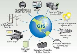
The field of Geospatial Data Science is rapidly ushering in a transformative era for civil engineering practices, empowering professionals to extract unprecedented insights from an ever-growing volume of location-aware data. From high-resolution satellite imagery and intricate LiDAR scans to real-time data streams from IoT sensors embedded in infrastructure and aggregated information from mobile devices, the availability of spatial data is exponentially expanding. When combined with advanced analytical techniques and computational power, this interdisciplinary field—which seamlessly merges Geographic Information Systems (GIS), core data science principles, and sophisticated remote sensing methodologies—enables civil engineers to gain a far deeper understanding of complex spatial phenomena. This enhanced understanding is crucial for facilitating more informed and strategic decision-making, optimizing the intricate processes of infrastructure planning and design, vastly improving asset management efficiencies, and bolstering resilience against escalating environmental challenges, thereby moving far beyond conventional, often static, map-based approaches.
Training Course on Geospatial Data Science for Civil Engineering is meticulously designed to equip civil engineers and related professionals with the essential theoretical foundations and, critically, the intensive practical skills required to proficiently apply geospatial data science methodologies specifically tailored for complex civil engineering challenges. The curriculum will encompass the entire lifecycle of spatial data: from acquiring, managing, and effectively visualizing diverse geospatial datasets to performing advanced spatial analysis, rigorous geostatistical modeling, and state-of-the-art machine learning applications on spatial data. Participants will learn to develop powerful predictive models for critical areas such as infrastructure performance, dynamic urban growth patterns, and complex environmental impacts. Emphasis will be placed on gaining hands-on experience with key software tools, fundamental programming languages (e.g., Python with its rich ecosystem of geospatial libraries), and in-depth real-world case studies, empowering attendees to confidently extract actionable intelligence from spatial data and apply it directly to solve the most pressing civil engineering problems.
Course Objectives
Upon completion of this course, participants will be able to:
- Analyze the fundamental concepts of geospatial data science and its applications in civil engineering.
- Comprehend the principles of acquiring, managing, and integrating diverse geospatial datasets relevant to infrastructure.
- Master various spatial analysis techniques for understanding geographic patterns and relationships.
- Develop expertise in geostatistical methods for interpolation, prediction, and uncertainty quantification of spatial data.
- Formulate strategies for applying machine learning algorithms to geospatial data for civil engineering problems.
- Understand the critical role of remote sensing data (satellite and aerial imagery) in large-scale infrastructure assessment.
- Implement robust approaches to visualizing and communicating complex geospatial insights through maps and dashboards.
- Explore key strategies for leveraging geospatial data science for urban planning, smart cities, and transportation analysis.
- Apply methodologies for assessing environmental impacts, climate resilience, and natural hazard risks using spatial data.
- Understand the importance of data governance, ethical considerations, and data privacy in geospatial applications.
- Develop preliminary skills in programming with Python and popular geospatial libraries for data manipulation and analysis.
- Design a comprehensive geospatial data science workflow for a specific civil engineering challenge.
- Examine global best practices and future trends in advanced geospatial data science for infrastructure development.
Target Audience
This course is essential for professionals seeking to integrate data science and spatial analysis into their work:
- Civil Engineers: Seeking to integrate data science and spatial analysis into their projects.
- Urban Planners & Developers: Aiming for data-driven insights in city planning and infrastructure development.
- GIS Analysts & Specialists: Looking to enhance their skills with advanced data science techniques.
- Data Scientists: Interested in applying their expertise to complex geospatial and civil engineering problems.
- Environmental Engineers: Focused on spatial analysis for environmental impact assessment and sustainability.
- Transportation Engineers: Utilizing geospatial data for traffic modeling, network optimization, and planning.
- Infrastructure Asset Managers: Employing spatial analytics for condition assessment and predictive maintenance.
- Researchers & Academia: Exploring innovative applications of geospatial data science in the built environment.
Course Duration: 10 Days
Course Modules
- Module 1: Foundations of Geospatial Data Science and Civil Engineering Context
- Define Geospatial Data Science and its interdisciplinary nature (GIS, Data Science, Remote Sensing).
- Discuss the unique characteristics of geospatial data (e.g., spatial autocorrelation, non-stationarity).
- Understand the key challenges in civil engineering that geospatial data science can address.
- Explore common geospatial data types: vector (points, lines, polygons) and raster (imagery, grids).
- Identify potential value propositions and real-world case studies in civil engineering.
- Module 2: Geospatial Data Acquisition and Management
- Comprehend various sources of geospatial data: satellite imagery, aerial photos, LiDAR, GPS, IoT sensors, open data portals.
- Learn about data formats (e.g., Shapefile, GeoJSON, GeoTIFF, NetCDF, LAS) and their properties.
- Master techniques for data collection, cleaning, and quality control of geospatial datasets.
- Discuss coordinate reference systems (CRS) and spatial transformations.
- Explore geospatial databases and cloud-based platforms for data storage and management.
- Module 3: Geospatial Data Visualization and Cartography
- Develop expertise in creating effective and informative maps for civil engineering projects.
- Learn about principles of cartographic design, symbology, and labeling.
- Master techniques for visualizing spatial patterns, relationships, and temporal changes.
- Discuss interactive web mapping platforms and dashboard development for geospatial insights.
- Gain hands-on experience with GIS software and programming libraries for visualization.
- Module 4: Core Spatial Analysis Techniques
- Formulate strategies for applying fundamental spatial analysis tools.
- Understand proximity analysis (buffers, nearest neighbor), overlay analysis (intersection, union).
- Explore network analysis (shortest path, service areas) for transportation and utility networks.
- Discuss surface analysis (slope, aspect, visibility) for terrain modeling.
- Apply spatial statistics for understanding spatial distributions and patterns.
- Module 5: Geostatistical Analysis for Civil Engineering
- Understand the critical role of geostatistics in interpolating and predicting values from sparse spatial data.
- Implement robust approaches to variogram modeling and spatial autocorrelation analysis.
- Explore techniques for kriging (ordinary, universal) and inverse distance weighting (IDW).
- Discuss the quantification of uncertainty and confidence in spatial predictions.
- Apply geostatistical methods for soil property mapping, pollution dispersion, and resource estimation.
- Module 6: Remote Sensing for Infrastructure Assessment
- Apply methodologies for processing and interpreting satellite and aerial imagery for civil engineering.
- Master techniques for image classification (supervised, unsupervised) and change detection.
- Understand the use of different spectral bands for feature extraction (e.g., vegetation health, water bodies).
- Discuss the integration of drone imagery for high-resolution site assessment and monitoring.
- Explore applications in land use/land cover mapping, environmental monitoring, and disaster response.
- Module 7: Machine Learning with Geospatial Data
- Explore key strategies for applying machine learning algorithms to spatial datasets.
- Learn about supervised learning (e.g., Random Forests, Gradient Boosting) for spatial prediction and classification.
- Discuss unsupervised learning (e.g., clustering) for identifying spatial clusters and anomalies.
- Understand deep learning architectures (e.g., CNNs) for image segmentation and object detection.
- Apply ML for urban growth modeling, traffic prediction, and infrastructure condition assessment.
- Module 8: Geospatial Data Science for Urban Planning and Smart Cities
- Implement robust approaches to leveraging geospatial data science for urban development.
- Learn about site suitability analysis, accessibility modeling, and land use planning.
- Discuss the use of spatial data for smart city initiatives (e.g., sensor network optimization, resource management).
- Explore applications in population distribution modeling and social equity analysis.
- Formulate strategies for data-driven decision-making in urban infrastructure projects.
- Module 9: Geospatial Data Science for Transportation Engineering
- Apply methodologies for analyzing transportation networks using geospatial data.
- Master techniques for traffic flow analysis, congestion mapping, and route optimization.
- Understand the use of GPS data and mobile sensing for origin-destination studies.
- Discuss applications in public transit planning, intelligent transportation systems (ITS), and infrastructure maintenance scheduling.
- Explore predictive modeling for traffic patterns and accident hotspots.
- Module 10: Environmental and Hazard Analysis using Geospatial Data
- Understand the critical role of geospatial data science in environmental assessment.
- Implement robust approaches to flood modeling, landslide susceptibility mapping, and erosion analysis.
- Explore techniques for analyzing air and water quality data in a spatial context.
- Discuss the use of remote sensing for disaster preparedness, damage assessment, and recovery planning.
- Apply spatial analysis for climate change impact assessment on infrastructure.
- Module 11: Geospatial Programming with Python
- Develop preliminary skills in programming with Python for geospatial data manipulation and analysis.
- Learn to use key libraries: GeoPandas for vector data, Rasterio for raster data, Shapely for geometric operations.
- Master techniques for automating spatial analysis workflows and batch processing.
- Discuss data integration from various sources using Python scripts.
- Practice building custom geospatial tools and applications.
- Module 12: Advanced Topics, Ethics, and Future Trends
- Examine global best practices and innovative research in geospatial data science.
- Explore emerging trends: real-time spatial analytics, big geospatial data, distributed computing.
- Discuss ethical considerations, data privacy, and bias in geospatial AI/ML applications.
- Understand the role of geospatial digital twins and immersive visualization.
- Design a strategic roadmap for integrating advanced geospatial data science capabilities into a civil engineering organization.
Training Methodology
- Interactive Workshops: Facilitated discussions, group exercises, and problem-solving activities.
- Case Studies: Real-world examples to illustrate successful community-based surveillance practices.
- Role-Playing and Simulations: Practice engaging communities in surveillance activities.
- Expert Presentations: Insights from experienced public health professionals and community leaders.
- Group Projects: Collaborative development of community surveillance plans.
- Action Planning: Development of personalized action plans for implementing community-based surveillance.
- Digital Tools and Resources: Utilization of online platforms for collaboration and learning.
- Peer-to-Peer Learning: Sharing experiences and insights on community engagement.
- Post-Training Support: Access to online forums, mentorship, and continued learning resources.
Register as a group from 3 participants for a Discount
Send us an email: info@datastatresearch.org or call +254724527104
Certification
Upon successful completion of this training, participants will be issued with a globally recognized certificate.
Tailor-Made Course
We also offer tailor-made courses based on your needs.
Key Notes
- Participants must be conversant in English.
- Upon completion of training, participants will receive an Authorized Training Certificate.
- The course duration is flexible and can be modified to fit any number of days.
- Course fee includes facilitation, training materials, 2 coffee breaks, buffet lunch, and a Certificate upon successful completion.
- One-year post-training support, consultation, and coaching provided after the course.
- Payment should be made at least a week before the training commencement to DATASTAT CONSULTANCY LTD account, as indicated in the invoice, to enable better preparation.