Training Course on Drone Use in Wildlife Monitoring and Conservation
Training Course on Drone Use in Wildlife Monitoring and Conservation is designed to empower conservationists, researchers, and environmental stakeholders with the technical and analytical skills to deploy unmanned aerial vehicles (UAVs) effectively.
Course Overview
Training Course on Drone Use in Wildlife Monitoring and Conservation
Introduction
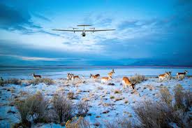
In today’s fast-evolving world of conservation technology, drones have emerged as revolutionary tools in wildlife monitoring, data collection, anti-poaching efforts, and habitat management. Training Course on Drone Use in Wildlife Monitoring and Conservation is designed to empower conservationists, researchers, and environmental stakeholders with the technical and analytical skills to deploy unmanned aerial vehicles (UAVs) effectively. With a focus on practical application, environmental impact assessment, and data analytics, participants will explore how drone technology is reshaping biodiversity conservation and ecosystem protection.
Participants will gain hands-on experience in drone flight operations, image and video data processing, AI-based species recognition, and real-time surveillance for anti-poaching missions. Leveraging global best practices and real-world case studies, this course merges environmental science, aviation compliance, and cutting-edge tech into a powerful learning experience to drive smarter and more sustainable conservation efforts.
Course Duration
10 days
Course Objectives
- Understand the fundamentals of drone technology for ecological and wildlife applications.
- Learn drone regulations and legal frameworks for conservation projects.
- Master real-time monitoring of wildlife habitats using aerial imaging.
- Gain skills in thermal and multispectral imaging for wildlife population estimation.
- Conduct anti-poaching surveillance using drone patrol systems.
- Use AI-powered drone software for species detection and tracking.
- Implement data-driven conservation strategies using drone-captured data.
- Explore case studies from global conservation programs using UAVs.
- Plan and execute drone mapping missions for ecosystem monitoring.
- Integrate drones into sustainable land and forest management plans.
- Understand weather and environmental constraints in drone operations.
- Learn emergency response applications of drones in wildlife conflict zones.
- Build a drone-based conservation project proposal using industry standards.
Organizational Benefits
- Enhanced conservation data accuracy and faster decision-making.
- Reduced field survey costs and time with drone automation.
- Improved anti-poaching intelligence and enforcement capabilities.
- Stronger community and stakeholder engagement using drone visuals.
- Increased global visibility through tech-enabled conservation programs.
- Seamless integration of AI and GIS mapping in wildlife studies.
Target Participants
- Wildlife Conservation Officers
- Environmental Scientists
- National Park Rangers
- Forestry and Land Management Professionals
- Drone Technicians and Operators
- NGO Staff in Wildlife Protection
- Research Scholars in Ecology
- Policymakers and Environmental Advocates
Course Outline
Module 1: Introduction to Drones in Conservation
- History and evolution of drone use in environmental science
- Types of drones used in wildlife monitoring
- Drone components and flight dynamics
- Regulatory landscape overview
- Case Study: Kruger National Park Anti-Poaching
Module 2: Flight Training & Safety Protocols
- Pre-flight checklists and airworthiness
- Weather forecasting for drone missions
- Emergency procedures and landing protocols
- Remote pilot licensing and certifications
- Case Study: Serengeti Wildlife Survey
Module 3: Aerial Imaging and Data Collection
- High-resolution photography and videography
- Real-time data transmission tools
- Image stabilization techniques
- Data storage and retrieval systems
- Case Study: Amazon Rainforest Habitat Imaging
Module 4: Mapping and GIS Integration
- GPS tagging and waypoint navigation
- Orthomosaic map creation
- GIS data layering with wildlife tracking
- Vegetation health indexing
- Case Study: Elephants Without Borders GIS Mapping
Module 5: Thermal & Multispectral Imaging
- Identifying nocturnal species with infrared
- Using spectral bands for plant and animal health
- Drone-mounted sensor calibration
- Interpreting thermal data with AI
- Case Study: Snow Leopard Tracking in Himalayas
Module 6: Anti-Poaching and Surveillance Drones
- Night patrol route planning
- Live stream capabilities in remote areas
- Drone swarms and perimeter alerts
- Collaborating with ranger ground units
- Case Study: Chyulu Hills Poaching Prevention
Module 7: AI-Powered Detection Systems
- Object recognition algorithms
- Machine learning in species ID
- Integrating AI models with drone visuals
- Predictive analytics for habitat threats
- Case Study: AI-Driven Bird Migration Tracking
Module 8: Conservation Project Planning
- Defining project goals and outcomes
- Stakeholder mapping and collaboration
- Budgeting and resource planning
- Monitoring and evaluation metrics
- Case Study: Smart Forest India Initiative
Module 9: Drone Maintenance & Troubleshooting
- Battery and motor diagnostics
- Common flight issues and repairs
- Software updates and firmware upgrades
- Building custom drones for rough terrain
- Case Study: Custom Drone Use in Congo Basin
Module 10: Legal and Ethical Considerations
- Airspace permissions and wildlife safety
- Ethical boundaries in drone surveillance
- Public and private land use laws
- Wildlife disturbance minimization
- Case Study: Legal Battle Over Drone Wildlife Footage
Module 11: Data Analytics for Conservation
- Image classification and object counting
- Mapping movement patterns
- Temporal change analysis
- Conservation dashboards and reporting
- Case Study: Coral Reef Monitoring in Maldives
Module 12: Forest and Land Management
- Assessing deforestation and illegal logging
- Integrating drones in REDD+ programs
- Measuring biodiversity hotspots
- Forest fire monitoring and rapid response
- Case Study: Drone Reforestation in Brazil
Module 13: Coastal and Marine Monitoring
- Monitoring nesting sites and marine mammals
- Underwater drones and coral reef scans
- Tide and erosion mapping
- Pollution detection via aerial view
- Case Study: Sea Turtle Nesting in Kenya
Module 14: Emergency and Disaster Response
- Rapid habitat assessment post-floods or fire
- Drone use in animal rescue missions
- Emergency payload drops for stranded species
- Coordinating with disaster response teams
- Case Study: Drone Deployment After Australian Bushfires
Module 15: Final Project & Certification
- Capstone project proposal development
- Group drone missions and simulations
- Peer review and expert feedback
- Project pitching and presentation
- Certification award ceremony
Training Methodology
- Live Drone Demonstrations
- Expert-Led Lectures and Interactive Q&A
- Group Projects and Simulations
- Real-World Case Study Analysis
- Field Practicum & Assessments
Register as a group from 3 participants for a Discount
Send us an email: [email protected] or call +254724527104
Certification
Upon successful completion of this training, participants will be issued with a globally- recognized certificate.
Tailor-Made Course
We also offer tailor-made courses based on your needs.
Key Notes
a. The participant must be conversant with English.
b. Upon completion of training the participant will be issued with an Authorized Training Certificate
c. Course duration is flexible and the contents can be modified to fit any number of days.
d. The course fee includes facilitation training materials, 2 coffee breaks, buffet lunch and A Certificate upon successful completion of Training.
e. One-year post-training support Consultation and Coaching provided after the course.
f. Payment should be done at least a week before commence of the training, to DATASTAT CONSULTANCY LTD account, as indicated in the invoice so as to enable us prepare better for you.