Training course on Advanced GIS for Urban Planning and Infrastructure Siting
Training Course on Advanced GIS for Urban Planning and Infrastructure Siting is meticulously designed to equip professionals with a thorough understanding and, crucially, hands-on practical mastery of advanced GIS functionalities specifically tailored to address the unique challenges of urban planning and infrastructure siting.
Course Overview
Training Course on Advanced GIS for Urban Planning and Infrastructure Siting
Introduction
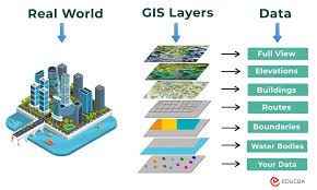
In an increasingly interconnected and rapidly evolving urban landscape, Advanced Geographic Information Systems (GIS) have become an indispensable tool for navigating the multifaceted complexities inherent in modern urban planning and the strategic siting of critical infrastructure. GIS provides a profoundly powerful and dynamic framework, enabling planners and engineers to seamlessly integrate, visualize, and rigorously analyze vast and diverse amounts of spatial data. This capability empowers them to gain deep insights into intricate urban dynamics, accurately assess potential environmental impacts, strategically optimize resource allocation, and precisely identify the most suitable locations for new developments. Ultimately, Advanced GIS facilitates data-driven decision-making, significantly mitigates inherent risks, fosters genuinely sustainable urban growth, and ensures the highly efficient and effective deployment of essential infrastructure, which is paramount for resilient cities.
Training Course on Advanced GIS for Urban Planning and Infrastructure Siting is meticulously designed to equip professionals with a thorough understanding and, crucially, hands-on practical mastery of advanced GIS functionalities specifically tailored to address the unique challenges of urban planning and infrastructure siting. The curriculum will guide participants through sophisticated spatial analysis techniques, including advanced multi-criteria evaluation, complex network analysis, and predictive modeling for urban phenomena. Attendees will also learn to effectively leverage high-resolution remote sensing data, integrate detailed Building Information Models (BIM), and proficiently utilize 3D GIS for immersive urban visualization and rigorous analytical assessment. With a balanced blend of robust theoretical foundations and extensive, practical hands-on exercises, this course will prepare participants to conduct precise site suitability analyses, optimize critical infrastructure networks, and make substantial contributions to developing resilient, intelligent, and sustainably planned urban environments.
Course Objectives
Upon completion of this course, participants will be able to:
- Analyze the fundamental concepts of Advanced GIS and its transformative role in urban planning and infrastructure siting.
- Comprehend the principles of advanced geospatial data management, integration, and quality assurance.
- Master various sophisticated spatial analysis techniques for site suitability and urban growth modeling.
- Develop expertise in leveraging remote sensing data (satellite imagery, LiDAR) for urban assessment.
- Formulate strategies for applying network analysis for optimizing transportation and utility infrastructure.
- Understand the critical role of 3D GIS for urban visualization, planning, and impact assessment.
- Implement robust approaches to multi-criteria evaluation (MCE) for complex infrastructure siting decisions.
- Explore key strategies for integrating BIM data with GIS for comprehensive infrastructure planning.
- Apply methodologies for assessing environmental impacts and natural hazard risks in urban areas using GIS.
- Understand the importance of data governance, ethical considerations, and stakeholder engagement in GIS-driven planning.
- Develop preliminary skills in automating GIS workflows and custom tool development.
- Design a comprehensive GIS-based framework for a specific urban planning or infrastructure siting project.
- Examine global best practices and future trends in Advanced GIS for smart urban development and resilient infrastructure.
Target Audience
This course is essential for professionals seeking to enhance their analytical and decision-making capabilities using advanced GIS:
- Urban Planners: Seeking to enhance their analytical and decision-making capabilities with advanced GIS.
- Civil Engineers: Interested in optimizing infrastructure siting, design, and management using spatial analysis.
- GIS Specialists & Analysts: Aiming to deepen their expertise in advanced GIS applications for planning.
- Infrastructure Project Managers: Responsible for site selection, feasibility studies, and project planning.
- Environmental Consultants: Focused on spatial assessment of environmental impacts and sustainability.
- Land Developers: Utilizing GIS for site analysis, market assessment, and optimal land use.
- Government Officials: Involved in municipal planning, public works, and smart city initiatives.
- Geospatial Data Scientists: Looking to apply advanced analytical methods to urban and infrastructure challenges.
Course Duration: 5 Days
Course Modules
- Module 1: Foundations of Advanced GIS for Urban and Infrastructure Context
- Define Advanced GIS concepts and its evolution in urban planning and infrastructure development.
- Discuss the key challenges in urban areas and infrastructure siting that GIS can address.
- Understand the importance of spatial data accuracy, precision, and resolution for planning decisions.
- Explore the integration of various data sources: cadastral, demographic, environmental, infrastructure.
- Identify the legal and ethical considerations in using geospatial data for public planning.
- Module 2: Advanced Geospatial Data Management and Quality Control
- Comprehend principles of geodatabase design, feature datasets, and network datasets.
- Learn about advanced data validation, topology rules, and error detection in spatial data.
- Master techniques for data harmonization, conversion, and integration from diverse sources.
- Discuss strategies for managing large-scale, dynamic geospatial datasets (e.g., versioning).
- Explore cloud-based GIS platforms for collaborative data management.
- Module 3: Site Suitability and Multi-Criteria Evaluation (MCE)
- Develop expertise in conducting comprehensive site suitability analysis using GIS.
- Learn about defining criteria, weighting factors, and standardization methods for MCE.
- Master techniques for weighted overlay, fuzzy logic, and analytical hierarchy process (AHP) in GIS.
- Discuss applications in selecting optimal locations for new infrastructure (e.g., waste treatment plants, public facilities).
- Gain hands-on experience in building and running MCE models in GIS software.
- Module 4: Network Analysis for Infrastructure Planning
- Formulate strategies for applying advanced network analysis to transportation and utility networks.
- Understand concepts like shortest path, optimal routing, service areas, and facility location.
- Explore applications in emergency response planning, public transit optimization, and utility network design.
- Discuss techniques for network modeling, including impedance, turns, and restrictions.
- Learn about optimizing resource allocation and logistics using network analysis.
- Module 5: 3D GIS for Urban Visualization and Analysis
- Understand the critical role of 3D GIS in urban planning, visualization, and impact assessment.
- Implement robust approaches to creating realistic 3D city models from 2D data, LiDAR, and BIM.
- Explore techniques for viewshed analysis, shadow analysis, and volumetric calculations in 3D.
- Discuss applications in urban design, zoning enforcement, and public participation.
- Gain hands-on experience with 3D modeling and visualization tools in GIS.
- Module 6: Remote Sensing Integration for Urban Assessment
- Apply methodologies for integrating satellite and aerial imagery into urban planning workflows.
- Master techniques for land use/land cover classification and change detection over time.
- Understand the use of LiDAR data for generating detailed digital terrain and surface models.
- Discuss applications in impervious surface mapping, green infrastructure assessment, and urban heat island analysis.
- Explore the use of drone imagery for high-resolution site assessment.
- Module 7: GIS for Environmental and Hazard Planning
- Explore key strategies for leveraging GIS in environmental impact assessment and risk mitigation.
- Learn about modeling floodplains, landslide susceptibility, and seismic hazards.
- Discuss the use of GIS for assessing habitat fragmentation, biodiversity, and ecosystem services.
- Understand applications in climate change adaptation planning and urban resilience strategies.
- Formulate strategies for integrating regulatory requirements into spatial analysis.
- Module 8: Advanced Topics, Automation, and Future Trends
- Examine global best practices in GIS for urban planning and infrastructure siting.
- Develop preliminary skills in automating GIS tasks using Python scripting (ArcPy, QGIS PyQGIS).
- Discuss integrating GIS with other analytical tools (e.g., statistical software, simulation models).
- Explore emerging trends: real-time GIS, big data analytics, AI/ML in GIS, web GIS, Digital Twins.
- Design a strategic framework for implementing advanced GIS capabilities in an urban planning or engineering department.
Training Methodology
- Interactive Workshops: Facilitated discussions, group exercises, and problem-solving activities.
- Case Studies: Real-world examples to illustrate successful community-based surveillance practices.
- Role-Playing and Simulations: Practice engaging communities in surveillance activities.
- Expert Presentations: Insights from experienced public health professionals and community leaders.
- Group Projects: Collaborative development of community surveillance plans.
- Action Planning: Development of personalized action plans for implementing community-based surveillance.
- Digital Tools and Resources: Utilization of online platforms for collaboration and learning.
- Peer-to-Peer Learning: Sharing experiences and insights on community engagement.
- Post-Training Support: Access to online forums, mentorship, and continued learning resources.
Register as a group from 3 participants for a Discount
Send us an email: info@datastatresearch.org or call +254724527104
Certification
Upon successful completion of this training, participants will be issued with a globally recognized certificate.
Tailor-Made Course
We also offer tailor-made courses based on your needs.
Key Notes
- Participants must be conversant in English.
- Upon completion of training, participants will receive an Authorized Training Certificate.
- The course duration is flexible and can be modified to fit any number of days.
- Course fee includes facilitation, training materials, 2 coffee breaks, buffet lunch, and a Certificate upon successful completion.
- One-year post-training support, consultation, and coaching provided after the course.
- Payment should be made at least a week before the training commencement to DATASTAT CONSULTANCY LTD account, as indicated in the invoice, to enable better preparation.