Training course on Advanced Drone Surveying and Photogrammetry for Civil Engineers
Training Course on Advanced Drone Surveying and Photogrammetry for Civil Engineers is meticulously designed to provide civil engineers and related professionals with a deep theoretical understanding and, crucially, extensive hands-on practical skills in advanced drone operations and sophisticated photogrammetry processing workflows.
Course Overview
Training Course on Advanced Drone Surveying and Photogrammetry for Civil Engineers
Introduction
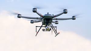
The civil engineering and surveying sectors are currently experiencing a profound transformation, largely driven by the revolutionary capabilities of Unmanned Aerial Vehicles (UAVs), commonly known as drones, when synergistically combined with advanced photogrammetry techniques. These cutting-edge technologies are rapidly superseding traditional, often arduous, time-consuming, and inherently hazardous manual surveying methodologies. Drones offer an unparalleled capacity for efficiency, accuracy, and detail in geospatial data collection, fundamentally reshaping how projects are planned, executed, and monitored. Their ability to capture high-resolution imagery and generate exquisitely precise 3D models of diverse features—ranging from intricate terrain and existing infrastructure to dynamic construction sites—is revolutionizing critical civil engineering tasks such as meticulous site planning, real-time progress monitoring, accurate volumetric calculations, and comprehensive asset inspection. This integration of drone technology is leading to significant cost savings, accelerated project timelines, improved decision-making, and ultimately, superior project outcomes across the built environment.
Training Course on Advanced Drone Surveying and Photogrammetry for Civil Engineers is meticulously designed to provide civil engineers and related professionals with a deep theoretical understanding and, crucially, extensive hands-on practical skills in advanced drone operations and sophisticated photogrammetry processing workflows. The curriculum will delve into the intricacies of strategic flight planning tailored for diverse civil engineering applications, advanced data acquisition techniques including oblique imagery, thermal sensing, and seamless LiDAR integration, as well as robust photogrammetry processing methodologies. Participants will gain mastery over essential concepts like accurate ground control points (GCPs), precise georeferencing, and the generation of high-fidelity orthomosaics, Digital Elevation Models (DEMs), detailed 3D point clouds, and intricate mesh models. With a strong emphasis on regulatory compliance, stringent safety protocols, and practical exercises utilizing professional-grade software and hardware, this course will empower civil engineers to confidently deploy drone technology for their complex projects and extract actionable, precise insights from geospatial data.
Course Objectives
Upon completion of this course, participants will be able to:
- Analyze the fundamental concepts of drone technology and photogrammetry in civil engineering applications.
- Comprehend the principles of drone flight planning, navigation, and safe operation for surveying tasks.
- Master various data acquisition techniques, including imagery, thermal, and LiDAR integration for civil engineering projects.
- Develop expertise in photogrammetry software for processing drone-acquired data into accurate 2D and 3D models.
- Formulate strategies for applying drone surveying for site reconnaissance, topographic mapping, and volumetric calculations.
- Understand the critical role of drone data in construction progress monitoring and quality control.
- Implement robust approaches to generating precise orthomosaics, Digital Elevation Models (DEMs), and 3D point clouds.
- Explore key strategies for integrating drone-derived data with BIM, CAD, and GIS platforms.
- Apply methodologies for conducting structural inspection, defect detection, and asset management using drone imagery.
- Understand the importance of regulatory compliance, safety protocols, and data security in commercial drone operations.
- Develop preliminary skills in evaluating and selecting appropriate drone hardware and software solutions for civil engineering needs.
- Design a comprehensive drone surveying and photogrammetry workflow for a specific civil engineering project.
- Examine global best practices and future trends in advanced drone technology for infrastructure development.
Target Audience
This course is essential for professionals seeking to enhance their skills in advanced surveying and geospatial data analysis:
- Civil Engineers: Seeking to integrate advanced surveying and mapping technologies into their projects.
- Land Surveyors: Aiming to enhance efficiency and accuracy using drone-based photogrammetry.
- Construction Managers: Interested in real-time site monitoring, progress tracking, and volumetric analysis.
- GIS Professionals: Looking to acquire high-resolution geospatial data for mapping and analysis.
- Infrastructure Inspectors: Exploring drone applications for safer and more efficient asset inspection.
- Project Managers: Responsible for overseeing site data collection and technology adoption.
- Urban Planners & Developers: Utilizing precise 3D models for planning and design.
- Environmental Engineers: Employing drones for site assessment and monitoring.
Course Duration: 10 Days
Course Modules
Module 1: Introduction to Drones and Photogrammetry in Civil Engineering
- Define UAV/Drone technology and its evolution for surveying applications.
- Discuss the fundamental principles of photogrammetry and its application in civil engineering.
- Understand the benefits of drone-based surveying over traditional methods (e.g., speed, safety, detail).
- Explore various types of drones (e.g., multi-rotor, fixed-wing) and their suitability for different tasks.
- Identify key use cases of drones in civil engineering projects (e.g., mapping, monitoring, inspection).
Module 2: Drone Regulations, Safety, and Best Practices
- Comprehend global and local regulatory frameworks for commercial drone operations.
- Learn about airspace classifications, flight restrictions, and licensing requirements.
- Master safe operating procedures, pre-flight checks, and emergency protocols.
- Discuss risk assessment, privacy considerations, and ethical responsibilities in drone surveying.
- Explore best practices for maintaining drone equipment and batteries.
Module 3: Advanced Drone Hardware and Sensors
- Develop expertise in evaluating and selecting professional-grade drones for civil engineering.
- Learn about different camera sensors (e.g., RGB, multispectral, thermal) and their specifications.
- Explore the integration of RTK/PPK GNSS systems for high-accuracy data acquisition.
- Discuss LiDAR technology on drones for capturing dense point clouds in vegetated areas.
- Understand payload considerations, flight endurance, and environmental factors impacting drone performance.
Module 4: Drone Mission Planning for Surveying
- Formulate strategies for effective flight planning for various civil engineering applications.
- Understand parameters for image overlap (frontlap and sidelap), altitude, and ground sampling distance (GSD).
- Explore automated flight planning software and setting up flight grids for different terrains.
- Discuss planning for linear infrastructure (roads, pipelines) and irregular sites.
- Learn about optimizing flight paths for efficiency and data quality.
Module 5: Ground Control Points (GCPs) and Georeferencing
- Understand the critical role of Ground Control Points (GCPs) in photogrammetry accuracy.
- Implement robust approaches to planning, surveying, and placing GCPs on-site.
- Explore techniques for precise georeferencing of drone imagery using surveyed GCPs.
- Discuss the impact of GCP distribution and quality on the final model accuracy.
- Learn about check points for validating model precision.
Module 6: Photogrammetry Processing Fundamentals
- Apply methodologies for processing drone-acquired imagery using professional photogrammetry software.
- Master techniques for image alignment, sparse point cloud generation, and bundle adjustment.
- Understand the principles of dense point cloud generation and meshing.
- Discuss various output formats: orthomosaic maps, Digital Elevation Models (DEMs), Digital Surface Models (DSMs), 3D point clouds, 3D meshes.
- Gain hands-on experience with photogrammetry software workflows.
Module 7: Data Product Generation and Quality Control
- Implement robust approaches to generating high-quality orthomosaics with precise scale and orientation.
- Learn about creating accurate DEMs/DSMs for topographic analysis and contour generation.
- Explore techniques for refining 3D point clouds and extracting features.
- Discuss quality control procedures for ensuring the accuracy and completeness of drone-derived products.
- Practice exporting data to various CAD/GIS-compatible formats.
Module 8: Applications in Site Planning and Topographic Mapping
- Formulate strategies for using drone-derived orthomosaics and DEMs for site reconnaissance.
- Understand how to create detailed topographic maps, cut/fill analyses, and drainage patterns.
- Explore applications in preliminary design, route planning, and earthwork calculations.
- Discuss the integration of drone data into preliminary engineering design workflows.
- Learn to generate quick and accurate baseline maps for any civil project.
Module 9: Applications in Construction Progress Monitoring and Volumetrics
- Understand the critical role of drone data in real-time construction progress monitoring.
- Implement robust approaches to tracking site changes, equipment movement, and material stockpiles.
- Explore techniques for accurate volumetric calculations for excavation and aggregates.
- Discuss the use of drone data for identifying construction deviations and quality control.
- Learn to generate daily/weekly progress reports from drone imagery.
Module 10: Applications in Infrastructure Inspection and Asset Management
- Apply methodologies for using drones for visual inspection of bridges, dams, roads, and utilities.
- Master techniques for identifying defects, cracks, and structural anomalies from imagery.
- Discuss the use of thermal cameras for detecting moisture ingress or energy loss.
- Explore how drone data informs asset inventory, condition assessment, and maintenance planning.
- Examine case studies of drone-enabled inspection workflows.
Module 11: Integration with BIM, CAD, and GIS
- Explore key strategies for integrating drone-derived data into existing BIM, CAD, and GIS environments.
- Learn about importing point clouds into CAD software for as-built modeling and clash detection.
- Discuss the use of orthomosaics and DEMs as base maps in GIS for spatial analysis.
- Understand how drone data updates and enriches digital twin models of infrastructure.
- Practice data interoperability workflows between various software platforms.
Module 12: Future Trends and Advanced Techniques
- Examine global best practices and innovative research in drone technology for civil engineering.
- Explore emerging trends: AI-powered data processing, swarm robotics, beyond visual line of sight (BVLOS).
- Discuss the integration of multi-sensor payloads and advanced analytics for comprehensive insights.
- Learn about drone-based construction (e.g., 3D printing, component assembly) and intelligent automation.
- Design a strategic roadmap for adopting and scaling advanced drone surveying within an organization.
Training Methodology
- Interactive Workshops: Facilitated discussions, group exercises, and problem-solving activities.
- Case Studies: Real-world examples to illustrate successful community-based surveillance practices.
- Role-Playing and Simulations: Practice engaging communities in surveillance activities.
- Expert Presentations: Insights from experienced public health professionals and community leaders.
- Group Projects: Collaborative development of community surveillance plans.
- Action Planning: Development of personalized action plans for implementing community-based surveillance.
- Digital Tools and Resources: Utilization of online platforms for collaboration and learning.
- Peer-to-Peer Learning: Sharing experiences and insights on community engagement.
- Post-Training Support: Access to online forums, mentorship, and continued learning resources.
Register as a group from 3 participants for a Discount
Send us an email: info@datastatresearch.org or call +254724527104
Certification
Upon successful completion of this training, participants will be issued with a globally recognized certificate.
Tailor-Made Course
We also offer tailor-made courses based on your needs.
Key Notes
- Participants must be conversant in English.
- Upon completion of training, participants will receive an Authorized Training Certificate.
- The course duration is flexible and can be modified to fit any number of days.
- Course fee includes facilitation, training materials, 2 coffee breaks, buffet lunch, and a Certificate upon successful completion.
- One-year post-training support, consultation, and coaching provided after the course.
- Payment should be made at least a week before the training commencement to DATASTAT CONSULTANCY LTD account, as indicated in the invoice, to enable better preparation.